Cache Summary:
This EarthCache is located in Pictured Rocks National Lakeshore. The cache can be accessed by parking at the Chapel Rock trailhead and hiking approximately 3 miles into the park. This EarthCache examines the power of weathering and erosion.
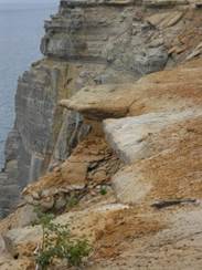
Figure 1. Weathering and erosion along Lake Superior Coastline. Photograph by: Nick Grabemeyer
Cache Coordinates: N 46˚32’54.49 W 86˚26’17.14
Parking/Trailhead Coordinates: N 46˚31’10.64 W 86˚27’44.92
EarthCache Lesson:
The Pictured Rock National Lakeshore has exposed bedrock dating from the Cambrian Period over 500 million years ago. The bedrock is exposed along the lake shore for about 17 miles from the Miners Castle area to the beginning of the Beaver Basin. The formation is called the Munising Formation and is divided up into three parts or members. The bottom layer is called the basal conglomerate, above is the Chapel Rock member, and finally the Miners Castle Member. These rocks are all sedimentary with varying degrees of exposure in the park. The Chapel Rock member is the most well known section of the formation. East of Mosquito River it is the primary member exposed. It is easy to distinguish from the other members as the Chapel Rock member is pinkish grey to brown, medium grained quartz sandstone with large scale cross-bedding. This cross-bedding indicates that the rock layer was formed in an environment where water was flowing.
Figure 2. Chapel Rock. Photograph by Nick Grabemeyer
The Chapel Member gets its name from a section of bedrock that has been separated from the mainland due to the powerful forces of erosion and weathering. Atop this rock grows a lone pine tree. This pine tree grows on this rock without any soil. To survive, the tree has sent roots over to the mainland where it can reach soil to obtain necessary water and nutrients. Until the 1940’s, the roots of the tree grew on top of a rock archway that connected the rock to the mainland. The tree’s roots survived the collapse of the arch and continue to nourish the tree to this day. Chapel Rock was formed from high water level during the Nippising high stand around 5000 years ago. The power behind the waves during this period of elevated water carved the rock out of the surrounding Cambrian bedrock.
This location serves as a wonderful reminder to all visitors that the earth is a dynamic constantly changing place. Some change occurs very rapidly (such as the collapse of the rock archway) while other changes occur more slowly. This location also reminds us that life, although fragile, can and will survive in the most unlikely of places.
Vocabulary:
Cross bedding: Formed in some sedimentary rocks when the depositional environment cause some to the sediments to be deposited at angles to the main rock layers.
Erosion: Occurs when particles loosened by weathering is moved by the force of wind, water, ice etc.
Weathering: Occurs when rock is broken down either chemical or physically into smaller particles.
Logging your visit:
To obtain credit for visiting this EarthCache, please email me the responses to the following questions (grabemeyernc@kalamazoo.k12.mi.us):
- What type of weathering or erosion do you think is currently having the greatest effect here and why?
- Do you think the tree roots are contributing to the weathering of this rock? (Please do NOT attempt to climb to this spot in order to respond to this question. Park staff have closed access to this spot for your safety and we ask that you make simple observations from a safe distance.)
Earth Science Literacy Principles Big Idea:
Big Idea 4: Earth is continuously changing.
Common Earth Science Misconception: The Earth has always been pretty much the way it is now.
This site and the lesson that accompanies it provide visibly striking evidence that our planet is constantly changing. Visitors will clearly be able to see the effects that weathering and erosion as had on the site featured in this cache.
The owner of this cache is a participant in the Michigan Teaching Excellence Program (MITEP) through Michigan Technological University, which teams with science teachers to improve science teaching and learning. This work was supported by the National Science Foundation award # 0831948.
References:
Blewett, William L. Geology and Landscape of Michigan’s Pictured Rocks National Lakeshore and Vicinity. Detroit, MI: Wayne State University Press, 2012.
Pictured Rocks National Lakeshore Scenic Sites. (July 29, 2013) Retrieved from: http://www.nps.gov/piro/planyourvisit/scenicsites.htm
Earth Science Literacy Principles. (May 2010) Retrieved from: http://www.earthscienceliteracy.org/
MiTEP List of Common Geoscience Misconceptions (n.d.) Retrieved from: http://hub.mspnet.org/media/data/MiTEP_List_of_Common_Geoscience_Misconceptions.pdf?media_000000007297.pdf
Geology Field Notes Pictured Rocks National Lakeshore. (January 4, 2005) Retrieved from: http://www.nature.nps.gov/geology/parks/piro/