Hidden at the top of the Keweenaw Peninsula is the Russell and Miriam Grinnell Memorial Nature Sanctuary. Within this 160-acre sanctuary you can take a beautiful hike to the top of Bare Bluff overlooking the Peninsula and Lake Superior. This hidden gem is remote, but worth the hike to those that seek to see a truly majestic view.
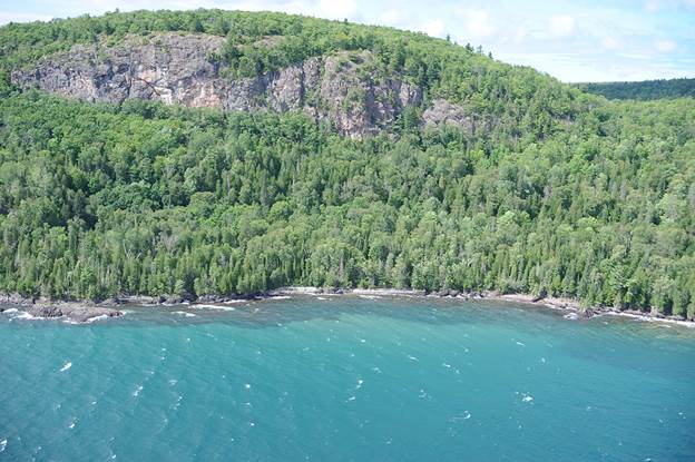
Figure 1 - Photo of Lake Superior shoreline showing Bare Bluff. Source:http://superiorwatersheds.org/shorelineviewer2011/photos/Keweenaw/0916.JPG
Coordinates:
- Parking Area = 47°23.829’N, 87°54.696’W
- Loop Trail Head = 47°23.787’N, 87°53.946’W
- Bare Bluff Overlook = 47°23.803’N, 87°53.334’W
- Steep Slope of Hike = 47°23.826’N, 87°53.228’W
Directions:
- Before you leave make sure you know how to use your GPS to enter and label waypoint coordinates as well as navigate to a waypoint.
- Follow the directions to the parking area. As you drive the Smith Fisheries Road does have a “private drive” sign but I was informed that it is in fact a public road and accessible to you to reach the sanctuary. This road can be a little rough so make sure to take it slow and a vehicle with four wheel drive may be preferable for some people.
- You will need to park in the parking area and then hike about 0.75 miles to the beginning of the loop (see figure 2 above). Read the introductory material and answer the logging questions in an email along with the other tasks to me to get credit (see the Logging Your Visit section below.)
Difficulty: 5.0
Terrain: The Bare Bluff hike is a 3 mile loop from what I will call the loop trail head at the beginning of the loop (see figure 2). You will reach this sign about 0.75 miles from the parking site after passing the trail head sign which lies between the parking area and the beginning of the loop trail. Depending on which direction you complete the hike the terrain can be very different. Below I will rate each direction with a description explaining each. If you are expecting to complete the entire loop I would recommend completing the hike in a counter clockwise direction for safety. Also, I would not recommend anyone with small children, pets or inexperienced hikers complete the entire loop. However, the bluff can still be experienced by going up the trail in the clockwise direction and then double back the same way to come back down to the trail head. Completing the entire loop in the clockwise direction will mean going down a very steep and rocky incline at the east side of the bluff.
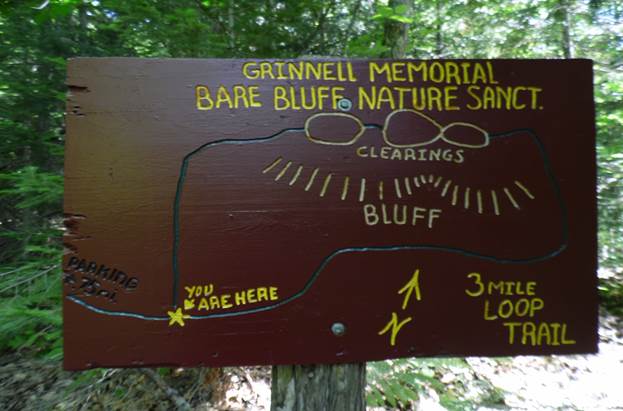
Figure 2 - Sign of trail loop. Source: photo by Josh Ernstes.
Counter Clockwise (right) = 5.0 (more difficult). This way will take you along the face of the bluff getting you very up close and personal with the cliffs. The trail can be very difficult at times with lots of rugged terrain covered with rocks and tree roots. Also, the trail can be overgrown at places making it hard to follow at times so please pay attention to trail markers that are positioned as much as possible on trees and other surfaces. After passing the cliffs you will reach the east side of the cliffs. From here you will need to ascend a steep and rocky cliff to reach the top of the bluffs which is why I suggest going in this direction as it would be much more dangerous coming down this section of the trail than going up. Watch your footing and take your time. Also, if you are in a group please make sure you give some distance between each member as some rocks may come loose and roll down the slope. Once at the top you can easily complete the loop back to the trail head after a short break and possible snack overlooking the Keweenaw and Lake Superior. Again, if you have pets, small children, members that are elderly or otherwise inexperienced I would not complete this part of the hike but use the other section of the loop to reach the summit.
Clockwise (left) = 3.5 (less difficult). This is still not an easy hike, but is definitely safer and easier for hikers with children, pets and elderly or less experienced hikers. The path is much more maintained and groomed but does have some sections with tree roots and rocks so please be careful of you footing in places. The ascent is also spread out over a much longer walk compared to the other direction making it easier for some hikers. Once at the top you can take in the beautiful views before returning back to the trailhead the same direction you came up. By backtracking you will avoid the steep and rocky slope and much of the more dangerous parts of the hike, but not miss out on experiencing the beauty the sanctuary has to offer.
I really like this hike because I feel it does give a nice option to hikers who are either looking for an easier hike through woods with some great views or the more adventurous hikers wanting to explore. Either way the end result is the same. The view from Bare Bluff is one you won’t forget and you will be glad you visited and whatever you do don’t forget your camera.
Vocabulary
- Fault – a fracture in the earth’s crust resulting in the relative displacement and loss of continuity of the rocks on either side of it.
- Igneous rock – a rock formed by the cooling and solidifying of molten materials either below earth’s surface from magma or on top of earth’s surface as lava.
- Rhyolite – a fine-grained igneous rock consisting of quartz, feldspars, and mica or amphibole.
- Basalt – a fine-grained dark basic igneous rock consisting of plagioclase feldspar, a pyroxene, and olivine: the most common volcanic rock.
Background and History Information
 There are three main types of lava. Bare Bluff is made of a rock named Rhyolite. Rhyolite is made from felsic lava that is very high in silica and aluminum content and tends to be very viscous. On the opposite side of the spectrum are the felsic lavas that are high in iron and magnesium and low in silica making them less viscous. In the middle you would find the intermediate or andesitic lavas that are in-between these two extremes as the name indicates. To read more about the lavas CLICK HERE. With this basic knowledge of lava flows it can help you determine what things may have been occurring related to lava flows by looking at what rocks are present.
The Keweenaw Peninsula was very different in the past. About 1.1 billion years ago this area was much more active as there was rifting and the crust was pulling apart. This rift was found under what we now call Lake Superior. During this time extensive lava flows occurred as the crust was pulling apart releasing magma from the mantle to come to Earth’s surface. This lava was mafic and resulted in the basalt that is very wide spread around the Keweenaw Peninsula. However, during this time the enormous heat caused some of the continental crust to also melt. This resulted in a different type of lava being formed, that of felsic lava because the continental crust was higher in silica content than the lower mantle magma.
Later when this tectonic activity halted and the lavas finished cooling rock layers were formed. This isolated melting resulted in the formation of pockets of Rhyolite that were buried beneath the ground. Later around 1.04-1.08 billion years ago a compressional force was placed on the area due to the Grenville tectonic zone. This squeezing force caused an uplift of the underlying rock layers as much as 3-5 kilometers. Within these now lifted rock layers were the pockets of Rhyolite like the one you will find here at Bare Bluff. To learn more about the Keweenaw FaultCLICK HERE.
Tour of Big Traverse Bay
After parking you will need to hike about 0.75 miles to the beginning of the loop trail. When you reach the sign take note of the elevation. I would suggest taking a waypoint with your GPS also.
Logging Question #1: In feet or meters, what is the elevation here at the beginning of the loop trail?
If you are going to complete the entire loop remember to complete the loop in a counter clockwise direction for safety. I added a small section with some extra info below. If you are going to the summit using the west section of the loop and then returning the same way you can skip the next section and proceed to the “View from the Summit” section below.
HIKERS DOING ENTIRE LOOP ONLY. As you walk you will reach the face of the bluff. As you hike observe the rock face and the unique rock found here at Bare Bluff. As you continue you can find places that show ice wedging and other erosional forces on the face of the bluff. When we were there hiking you could see a really good example of ice wedging near the steep rock slope at the east end of the slope. You will need to carefully climb the slope to the summit of the bluff.
View from the Summit
Once reaching the summit take in the beauty of the area. You will need to now take another GPS coordinate and note the elevation again.
Logging Question #2: In feet or meters, what is the elevation here at the summit? What was the overall elevation change that you completed between the sign at the beginning of the loop and the summit? (Feel free to round it to the nearest 10 feet/meters).
Once at the top observe the rocks. You will notice that the rock here if very different than many of the rocks found in the Keweenaw such as basalt, conglomerate and sandstone.
Logging Question #3: Examine the rhyolite rock outcrop at the summit and describe the color, texture, grain size, and luster.
Logging Question #4: Compare this outcrop to the basalt outcrops found throughout the Keweenaw. What do you think accounts for the differences?
Logging your Visit
To get credit for this cache you need to…
1. Email me the answers to the logging questions @ jdernstes@yahoo.com.
2. Include a picture from the overlook on top of the bluff with some evidence that you are there. Some people send a picture of them or their group with the view in the background or their pack, water bottle, thumbs up, etc. This is just a way to prove it was taken by you and not one from the internet. This is optional but a unique or funny picture would be appreciated! Below is mine.
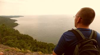
Figure 4 - Author on top of Bare Bluff.
Access Information
Bare Bluff is found within the Russell and Miriam Grinnell Memorial Nature Sanctuary which was established in 1982. The sanctuary is 160-acres with beautiful geological landscapes and a variety of plants and animals. The Michigan Nature Association owns and operates the sanctuary. The MNA was established in 1952 and is a nonprofit conservation organization that is dedicated to protecting Michigan’s unique habitats and species. The MNA now protects 164 nature sanctuaries in 54 counties around Michigan, over 8,500 acres in all.
Please respect the sanctuary and follow Leave No Trace guidelines. The tract is open to foot traffic only. Pets must be leashed and there are no horses, wheeled vehicles, fires, or camping allowed. Everything that is packed in must be packed out. “Leave only footprints, take only pictures.”
Michigan Nature Association (MNA) Website and Brochure
Date Visited
July 22, 2013
Connections to the Earth Science Curriculum
Essential Questions:
- How do plate tectonics create unique land features on Earth?
- What is the relationship between rock types and the molten material they are produced from?
Earth Science Literacy Principles’ Big Ideas
- 4.5 Many active geologic processes occur at plate boundaries. Plate interactions change the shapes, sizes, and positions of continents and ocean basins, the locations of mountain ranges and basins, the patterns of ocean circulation and climate, the locations of earthquakes and volcanoes, and the distribution of resources and living organisms.
- 4.7 Landscapes result from the dynamic interplay between processes that form and uplift new crust and processes that destroy and depress the crust. This interplay is affected by gravity, density differences, plate tectonics, climate, water, the actions of living organisms, and the resistance of Earth materials to weathering and erosion.
Misconceptions
- The basalt found in the UP came from violently erupting volcanoes.
- All rocks are the same.
- Rock layers are always flat.
Connections to the Earth Science Curriculum
- E3.p2B Identify common igneous (granite, basalt, andesite, obsidian, pumice), metamorphic (schist, gneiss, marble, slate, quartzite), and sedimentary (sandstone, limestone, shale, conglomerate) rocks and describe the processes that change one kind of rock to another.(prerequisite)
- E3.1B Explain the relationship between the rock cycle and plate tectonics theory in regard to the origins of igneous, sedimentary, and metamorphic rocks.
- E3.3A Explain how plate tectonics accounts for the features and processes (sea floor spreading, mid-ocean ridges, subduction zones, earthquakes and volcanoes, mountain ranges) that occur on or near the Earth’s surface.
The owner of this cache is a participant in the Michigan Teaching Excellence Program (MITEP) through Michigan Technological University, which teams with science teachers to improve science teaching and learning. This work was supported by the National Science Foundation award #0831948.
References and Citations
Michigan Nature Association. (2006). Russell and Miriam Grinnell Memorial Nature Sanctuary at Bare Bluff. Retrieved July 18, 2013, from Michigan Nature Association: http://www.michigannature.org/home/sancts/grinnell/grinnell.shtml
Rose, W. (2013, July). The Fault, So What? Retrieved July 23, 2013, from Keweenaw Fault Web site: http://www.geo.mtu.edu/~raman/SilverI/The_Fault/Welcome.html
Wikipedia. (2013, August 8). Lava. Retrieved August 13, 2013, from Wekipedia: http://en.wikipedia.org/wiki/Lava