Basic knowledge
- Basin is located in Western Africa.
- It covers over 2.27 million km2, which is 7.5% of the continent.
- The basin is shared by ten countries (Algeria, Benin, Burkina Faso, Cameroon, Chad, Côte d’Ivoire, Guinea, Mali, Niger and Nigeria).
- Approximately 150 million inhabitants throughout the basin.
- Lenght of the Niger River is 4200km.
- Third longest African river after Congo and Nile.
- River traverses four countries (Guinea, Mali, Niger, Nigeria), two of which are named after it.
- Average waterflow in Koulikoro (Mali) is 32,5 km3/year, which is half the average flow of the Rhine River at its outlet (data taken 1970-1998).
- Most important African river system.
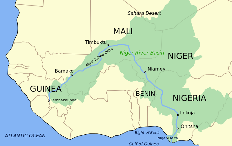
Map by Wikipedia
Advanced knowledge
- East-west expansion: 3,000 kilometers from Guinea to Chad.
- North-south expansion: 2,000 kilometers from the Guinean Hoggar Mountains to the Gulf of Guinea.
- Niger crosses two different climatic areas: Sahelian semiarid sub-desert zone and Sudanian savannas.
- Basin is divided into four sub basins:
- Upper Basin: river´s source is situated in the Fouta Djallon Massif in the Guinean Highlands at an altitude of about 800 meters, where rainfall reaches high 2000 mm/year.
- Central Delta: located in Mali, where up to 44% of the inflow dissapears through absorption and evaporation. The Inner Delta forms a large flood plain during rainy season of up to 50.000 km2.
- Middle Niger Basin: river reaches the frings of the Sahara and passes later on Niamey, Niger´s capital.
- Lower Niger: river is joined by its major tributary, the Benue River, which originates in Cameroon´s Adamawa Plateau. The Niger finally flows through the Niger Delta into the Gulf of Guinea.
- Water flow at Niamey: first high-water discharge (white flood) occurs soon after the rainy season in September; a second rise (black flood) begins in December—with the arrival of the delayed flood from upstream. May and June are the low-water months.
Expert knowledge
- The three major soil types of the Niger River Basin are ferralitic soils, tropical ferruginous soils and hydromorphic soils.
- Ferralitic soils are seen in the west of the Guinean basin, in the south of the Bani watershed, in the north of Benin and in the major part of the Niger River Basin in Nigeria, including the Benue watershed. These are thick soils (3 to 10 meters thick), where geochemical changes are extensive and spread over many millions of years.
- Lateritic layers can be seen on the surface or at short depths on top of a mix of the ferralitic and ferruginous soils; they are found in particular in Guinea and in southern Mali. This horizontal layer results from an upward migration of ferrous oxides and from their precipitation. Limited spots of tropical brown soil or tropical black clay (vertisols) can also be found.
- Bleached layers of ferruginous tropical soils are seen in the north of the Bani watershed, on the periphery of the Inland Delta in Mali, in the east of Burkina Faso, and along the northern part of the Niger River Basin and Benue watershed in Nigeria and Cameroon. They are associated with ferralitic soils in the Upper Niger River Basin upstream of Bamako and in the Kaduna watershed in Nigeria.
Logging tasks
Enjoy the view along the bridge over the river, take a picture and check out the following questions:
1) What is the present color of the water and which of the three main soil types is responsible for that?
2) List three possible causes for a high amount of sediments in the river. (Think about natural as well as man made reasons.)
3) How wide is the river at GZ today? Name a natural and an artificial factor which can influence the water level.
Please e-mail your anwsers and log your find!
Pictures from the river taken at GZ or elsewhere are always welcome!
Sources:
Please feel free to deepen your knowledge and explore more interesting details about the basin:
KfW, Adaptation to Climate Change in the Niger River Basin, 2010, Download
Cody McCann, The Niger River Basin, 2012, Download
Inger Andersen et al, The Niger River Basin: A Vision for Sustainable Management, 2005,Download