A parent material is a soil-science name for a weathered rock or deposit from, and within which a soil has formed. In the UK, parent materials provide the basic foundations and building blocks of the soil, influencing their texture, structure, drainage and chemistry. Soils are the result of weathering processes that occur on the Earth’s surface where the atmosphere meets the geosphere and hydrosphere. We live in this ‘critical zone’ relying on our soils to grow our food and sustain the biodiversity and health of our environment.
The Bristish Geology Survey are developing a national digital Parent Material Model (PMM) at 1:50 000 scale, detailing the distribution of physiochemical properties of the weathered and unweathered parent materials of the UK to:
facilitate spatial mapping of UK soil properties
identify soils and landscapes sensitive to erosion
provide a national overview of our soil resource
develop a better understanding of weathering properties and processes
Data content
The Parent Material Model details over 30 rock and sediment characteristics; it builds upon the standard DiGMapGB-50 geological dataset, adding simplified classifications of lithological properties. The project is also developing improved datasets for identifying key areas of peat, colluvium and aeolian deposits.
PPM Map

The PPM Map is constructed by layering the Soil compostion onto the Geology of Great Britain.
Kent Geology
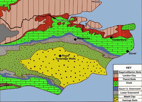
The Kentish rocks begin with fresh water sandstones and clays of the Wealden Series. These were deposited in a subsiding basin to the south of an old landmass known as the London Platform, now buried under North Kent and London. We can envisage shallow gravelly rivers flowing from these uplands, carrying sediment into an extensive area of low lying marshes with ponds, streams and sand banks. Sediments often show evidence of shallow water such as ripple marks, rootlets and even dinosaur footprints if you are lucky!
Eventually these uplands were lowered by erosion, only fine sediment was generated and the basin became a mud plain. Three sandstone/clay cycles can be recognised as the London Platform was repeatedly uplifted and eroded. As the uplift cycles waned an extensive mud plain developed that is preserved as the Weald Clay. Because sandstones predominate in the first and second cycle their resistance to weathering creates the rolling, wooded High Weald. The softer overlying Weald Clay forms the low-lying Low Weald.
The rocks of the Greensand Ridge mark a dramatic change to marine conditions as a shallow seaway was established between the North Sea and the southern Tethyan Ocean around the western end of the London Platform. Initially clays were deposited but gradually sands and sandy limestones came to predominate. Today these limestones, known as Kentish ragstone produce fertile soils whereas the sands give rise to poor acid soils with woodland and heath. Ragstone is beautifully displayed in old quarries around Maidstone, westward towards Sevenoaks and on the coast at Hythe. These pits record the long history of exploitation of Kent's most important building stone. Further pits adjacent to the M20 display the overlying Folkestone Sands also laid down in the seaway and now used for a variety of commercial products.
As we pass from the Greensands down into the Vale of Holmesdale the soils become heavy and clayey. This Gault Clay marks a widening of the old seaway as sea level began to rise dramatically. To see it, go to the coast at Copt Point Folkestone, the traditional place to find ammonites and a range of other Gault fossils in Kent.
Continuing our theme of rising sea level, eventually so much land was submerged that no sediment from land (sand/clay) could reach the Kentish area. Only the skeletons of tiny organisms, overwhelmingly those of calcareous algae, were deposited. They formed the Chalk that provides another fossil collecting opportunity. Today the Chalk forms Kent's most famous landscape features, the North Downs and the White Cliffs of Dover.
PH of Soil

Different nutrients are available at different soil pH levels. This affects the way plants and trees grow in different soils.
The Oak Tree and Pine Tree both prefers a pH of between 3.6 and 7
No crop is more closely associated with Kent Soil than the hop, even if the hop-garden is now quite rare. Hops prefer gowing in a soil with a pH between 6 and 7.5
There are three areas where the soil, climate and aspect are good for hops:
- East Kent, with its brick-earths, mainly around Faversham and Canterbury, always known for high quality hops;
- Mid-Kent, mainly the Medway valley, including the Maidstone district, on the Lower Greensand;
- Weald and High Weald, particularly the East Peckham and Yalding, and the large parishes to the south and east of Yalding, with their Weald Clay and Tunbridge Wells Sand.
The Earthcache:
From what you have researched and from visiting the following waypoints please answer the following questions. The answers should be e-mailed to me at my address on my profile page.
Question 1. Go to waypoint 1 N51 12.305 E000 23.000 What is the significance of this waypoint in terms of Geology, soil compostion and Crop growing?
Question 2. Go to Wapoint 2 N51 11.440 E000 23.210 Describe what you see at the edge of the field. What is the significance of this in terms of soil composition and crop growing? Also describe the soil type in terms of what it feels and looks like. In addition look at the second diagram and decide on which part of Kent you are in from a Geology perspective? Do you notice any white material in the soil? If so what is it called?
Question 3. Go to waypoint 3 N51 10.912 E000 22.082 Describe the landscape here and what is growing in the fields.
Question 4. During your walk N51 10.912 E000 22.082 . You will have noticed a variety of trees during your walk. List three types you have seen. Give the significance of seeing these variety of trees in terms of PH of the soil. Estimate what you think the pH of the soil is here using the information given to you.
Optional:
Question 5. upload a photo of yourself either by an oast house or holding a pint of Kentish Beer