FRANÇAIS :
Préparez-vous à découvrir une destination authentique et d’une grande diversité. Des plaines à niaoulis des espaces de l’ouest aux cascades noyées de verdure de la côte est et de la chaîne centrale, en passant par les collines arides du Grand Nord, les îlots et les plages désertes, la terre rouge du pays minier, le Nord calédonien a bien des choses à partager avec vous : une nature magnifique, une histoire riche, une biodiversité exceptionnelle, un lagon inscrit par l’Unesco au patrimoine mondial de l’humanité, une population multicolore au caractère bien trempé...
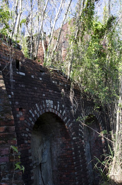
Cache N°12 : Usine de Pam
La fonderie de Pam fut construite vers 1886-1887. Pour permettre le traitement des minéraux de cuivre extraits des mines Pilou et Ao, c’est John Higginson, propriétaire de ces mines, qui en décida la construction. Ces installations ont été réalisées avec la main d’œuvre de 300 bagnards cédés par l’administration pénitenciaire. L’usine fonctionna pendant moins de deux ans pour ne reprendre qu’en 1895, avant de fermer définitivement en 1902. Le village construit autour de l’usine se dépeuplera peu à peu et sera définitivement abandonné dans les années 1970.
L’usine sidérurgique de Pam se composait de trois fours et d’une machine à vapeur qui produisait l’énergie nécessaire aux deux concasseurs. Une cuve à eau destinée à alimenter la machine à vapeur se situait au-dessus de celle-ci sur la falaise surplombant l’usine.
La piste carrossable (renseignez-vous en cas de fortes pluies) de 20 km depuis l’embranchement de Ouegoa (voir Waypoint) vous mènera le long de l’embouchure du Diahot jusqu’au bout de la péninsule, face à l’île Pam, dans un décor de bout du monde. En venant de Pouebo, vous pouvez aussi faire le tour de la péninsule dans l’autre sens en partant vers le camping d’Amos et Tiari au pied du col d’Amos.
Bien qu’envahis par la végétation, les vestiges de l’usine sont encore bien visibles. Il n’y a pas de serpents ni d’animaux dangereux en Nouvelle-Calédonie, mais on peut y rencontrer occasionnellement guêpes ou scolopendres. En vous frottant un peu trop aux arbres, vous ferez peut-être connaissance avec les fourmis « électriques » irritantes mais pas dangereuses ! Prévoyez des chaussures fermées et préférez un T-shirt à manches longues.
Apportez votre propre crayon.
Avant de repartir, merci de bien re-cacher la boîte, pour le plaisir du prochain géocacheur !
ENGLISH:
Get ready to explore an unusually diverse and authentic destination. From the niaouli plains of the open West Coast to the greenery-shrouded waterfalls of the East Coast and the central mountain chain, from the arid hills of the Far North to the islets, deserted beaches and red earth of the mining country, the North of New Caledonia has much to share with you: a magnificent natural environment, a rich history, exceptional biodiversity, a lagoon listed by UNESCO as part of the World Heritage, a rainbow-coloured population with a sturdy character…
Cache No 12: Pam plant
The Pam foundry was built around 1886-1887. John Higginson, owner of the Pilou and Ao mines, decided to build it to enable processing of the copper ore extracted from these mines. These facilities were constructed with the labour of 300 convicts assigned by the penitentiary administration. The plant operated for less than two years and only resumed operation in 1895, before finally closing in 1902. The village built around the plant gradually lost its population and was finally abandoned in the 1970s.
The Pam plant was made up of three furnaces and a steam engine that produced the power required for the two ore crushers. A water tank to supply the steam engine was situated above it on the cliff overlooking the plant.
The 20 km dirt road from the Ouegoa turnoff (see Waypoint), which is open to vehicles (make enquiries if there is heavy rain), will take you along the Diahot river mouth as far as the end of the peninsula, opposite Pam island, in an end-of-the-world setting. Coming from Pouebo, you can also go around the peninsula in the other direction, heading to the Amos campsite and Tiari tribal village at the foot of the Col d’Amos [Amos pass].
Although overgrown by vegetation, the plant’s remains are still quite visible. There are no snakes or dangerous animals in New Caledonia, but occasionally wasps or centipedes are encountered. If you rub against the trees too much, you may make the acquaintance of the “electric” ants which are irritating but not dangerous. Make sure you take closed-toe shoes and preferably a long-sleeved T-shirt.
Bring your own pencil.
Before setting off, please hide the box again, so the next geocacher has the fun of finding it!