As with all eathcaches, there is no container at the posted coordinates. In order to claim this one as a find, you need to answer the logging questions, and send me the answers by email.
Follow all posted rules
Park hours
Historic Site Grounds:
Sunrise to 10 p.m., year-round (except New Year's, Easter, Thanksgiving and Christmas days)
Bollinger Mill hours
Tours:
Tours are given on demand.
Summer Hours (On-Season)
March 15 through Nov. 15
10 a.m. - 4 p.m., Monday through Saturday (last tour begins at 3:30 p.m.)
Noon - 4 p.m., Sunday (last tour begins at 3:30 p.m.)
Winter Hours (Off-Season)
Nov. 16 through March 14
10 a.m. - 4 p.m. Monday and Thursday through Saturday (last tour begins at 3:30 p.m.)
Noon - 4 p.m. Sunday (last tour begins at 3:30 p.m.)
No tours are offered on Tuesday or Wednesday.
The historic site is closed New Year's, Easter, Thanksgiving and Christmas days.
Historic Site Office hours
8 a.m. to 4:30 p.m., Monday through Friday, year-round
Google maps has this river labeled as a creek, however the Missouri Department of Natural Resources as well as the locals and all map literature have always called this a river.
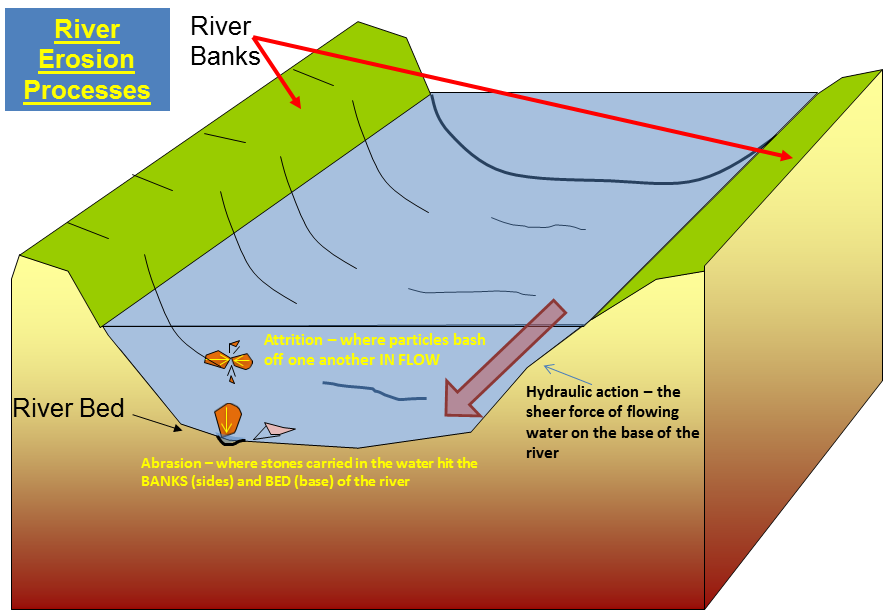
Erosion
Erosion is the process by which soil and rock are removed from the Earth's surface by natural processes such as wind or water flow, and then transported and deposited in other locations.
Types of Erosion:
Splash Erosion: Small soil particles are detached and sent airborne through the impact of raindrops on soil.
Sheet Erosion: Raindrops break apart the soil structure and it's moved down-slope by water that flows overland as a sheet rather than definitive channels. This occurs frequently during cloud bursts.
Rill Erosion: This process develops small, short-lived, concentrated flow paths. These paths create a sediment source and delivery system for hill-slope erosion. Areas where precipitation rates exceed soil infiltration rates are more prone to this type of erosion.
Gully Erosion: Water flows in narrow channels during or directly following heavy rains or melting snow. The gullies can erode to considerable depths.
Valley or Stream Erosion: Continual water flow alongside land (along a linear feature) creates this type of erosion. It extends downward, deepening a valley, and head-ward, extending the valley into the hillside. This occurs most frequently in times of flooding.
Bank Erosion: Over time, banks of rivers and streams are naturally worn down.
Freezing and thawing: Cold weather causes water trapped in tiny rock cracks to freeze and expand, breaking the rock into several pieces.
Wind erosion is a major geomorphological force, especially in arid and semi-arid regions. Wind erosion is of two primary varieties: deflation, where the wind picks up and carries away loose particles; and abrasion, where surfaces are worn down as they are struck by airborne particles carried by wind.
Mass movement is the downward and outward movement of rock and sediments on a sloped surface, mainly due to the force of gravity. Mass movement is an important part of the erosional process, and is often the first stage in the breakdown and transport of weathered materials in mountainous areas. It moves material from higher elevations to lower elevations where other eroding agents such as streams and glaciers can then pick up the material and move it to even lower elevations. Mass-movement processes are always occurring continuously on all slopes; some mass-movement processes act very slowly; others occur very suddenly, often with disastrous results.
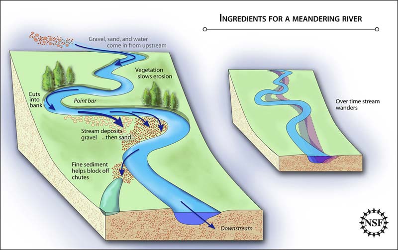
Deposits
As rivers carry dust, pebbles, and rocks downstream, this material is eventually deposited at some locations further down. These deposits form at bends in a river, as well as in locations where rivers dump water into lakes.
**Logging requirements**
DO NOT POST ANSWERS IN YOUR LOG.
Send the following answers to me via email.
- The text "GC55WP7 Upper whitewater creeks" on the first line
- No need to enter the creek, but what is the creek bed made out of?
- Measure the creeks width at the bridge, what is it?
- What man-made structure, which has two purposes here, is helping to slow down and control the erosion of the creek?
- How fast do you think the creek is flowing today?
| I have earned GSA's highest level: |
 |