ALL ABOUT TIDES
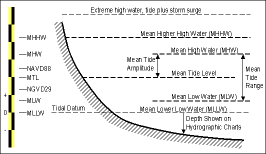
Tidal Datum (Chart Datum)
A chart datum is the level of water that charted depths displayed on a nautical chart are measured from. A chart datum is generally a tidal datum; that is, a datum derived from some phase of the tide.Common chart datums are lowest astronomical tide and mean lower low water (Low Water Springs).
Explanation of terms used in tides
Tidal Range
The tidal range is the vertical difference between the high tide and the succeeding low tide. Tides are the rise and fall of sea levels caused by the combined effects of the gravitational forces exerted by the Moon and the Sun and the rotation of the Earth. The tidal range is not constant, but changes depending on where the sun and the moon are in relation to a point on the Earth's surface.
The most extreme tidal range occurs around the time of the full or new moons, when the gravitational forces of both the Sun and Moon are in phase, reinforcing each other in the same direction (new moon), or are exactly the opposite phase (full). This type of tide is known as a spring tide. During neap tides, when the Moon and Sun's gravitational force vectors act in quadrature (making a right angle to the Earth's orbit), the difference between high and low tides is smaller. Neap tides occur during the first and last quarters of the moon's phases. The largest annual tidal range can be expected around the time of the equinox, if coincidental with a spring tide.

Tidal Range

Tidal Range wrt to the Shoreline
Tide height
The tide height is defined as the height of the water above Tidal (chart) Datum. In other words, at a spring low tide of 0.15m the mean water level will be 0.15m above the tidal datum. At High water springs for a tide height of 2.1m, the water level can be expected to be about 2.1m above the tidal datum.
Spring and Neap Tides
Spring tides are the biggest tides, caused by the gravitational pull of the moon being particularly strong. During a spring tide the water level will rise to its highest possible point at high tide, and at low tide the level will be at the lowest possible point. When anglers talk of there being a “big tide” they are referring to a spring tide occurring. The tidal flow during a spring tide will be very strong due to the large amount of water which flowing. Spring tides happen every two weeks during the time of a full or new moon. Neap tides also happen every two weeks during the period of the first and last quarter of the moon (in the weeks between spring tides). During a neap tide the high tide will not come up particularly high, and the low tide will not be particularly low, and the strength of the tide is likely to be fairly weak.

Influence of the Sun and Moon on Spring and Neap tides
We can use Durban as an example to see the difference between spring tides and neap tides: on a spring tide the high tide level can hit 2.1m on the local scale, and low tide down to 0.1m, while on a neap tide high tide only reaches 1.4m, and low tide 0.7m. See image below for June 2014.

Tidal height over time
Mean Sea Level
Mean sea level (MSL), commonly referred to as sea level, is a datum representing the average height of the ocean's surface (such as the halfway point between the mean high tide and the mean low tide); used as a standard in reckoning land elevation. MSL also plays an important role in marine navigation as a chart datum and aviation, where standard sea level pressure is used as the measurement datum of altitude at flight levels. Detection of long-term variations of mean sea level requires careful measurement but can provide information on climate change. Sea level responds to a variety of influences and has varied greatly over geologic time. Currently, sea level is rising, which scientists cite as evidence supporting the view that the climate system is warming.
The cache
The cache is located in a rock pool BELOW the Low Water Springs water level - which means that the elevation of this cache is 1 meter below sea level. You may mark it as -1m in your caching database!
In order to find this cache you will need to determine the date and time of spring low tide (which occurs a day or two after full or new moon). The best times to do this cache is within an hour before and after the time of Low Water Springs. Once you have found the tide times (use the suggested websites below), then you can plan your visit to the cache.
Check the tide times for Durban here.
See the image list below for the dates and times of the Moon phases for 2017. Alternatively click on the link just below.
Moon Phases 2017
Special Requirements
Please have a pair of waterpump pliers with you as sometimes the lid of the container gets jammed up with grains of sand.
Also note that the container may be buried under about 10cm of sea-sand in the hole due to wave action.
You will need swimming attire and water resistant footwear.
You MUST take your own pen or pencil with you and also take along a small towel to dry your hands before signing the log.
Ensure that all three containers (main container and the two sub-containers) are securely closed and watertight before replacing the cache.
The logsheet will be checked regularly, and any online logs where the names are not on the logsheet will be deleted.
I do not recommend that this cache be attempted if the tide height is greater than 0.25m.
Precautions
At high water spring tide, this cache will be under about 2m of water.
At Other tidal states:
Low Water Springs: About 0.35 m below water
High Water Neaps: About 1.5m below water
Low water Neaps: About 0.7m below water
Please wear good footwear that can handle sea water as there are sharp rocks and thousands of mussels at GZ.
Swimming attire is strongly recommended.
Ensure that you check and double check the tides before setting out for this cache.
Acknowledgements
Thanks to HovelJ for his local knowlege and assistance with placing this challenging cache. He will also help with regular checks on the logsheet and the health of the cache.
Thanks also to Hesamati for the idea - if you are ever in the Strand (Western Cape), make sure you do his similar cache - GC2N4G0
References
National Oceanic and Atmospheric Administration (USA)
British Sea Fishing
Tide Times and Tide Charts for the World
Tides for Fishing
Johannesburg Planetarium (Moon Phases 2014)
Johannesburg Planetarium (Moon Phases 2015)
All years Moon Phases