
 There are a few parking spots along Highway 1. There is even a handicapped spot with a wood boardwalk out a short ways into the dune where you can see some of the features. However, due to aeolian transport the boardwalk will likely be covered with dunes. I will accept answers from as far down the boardwalk as you can go if you are unable to make it onto the beach.
The beach is relatively narrow, so be careful at high tide and following storms.
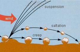 Eolian transport refers to the wind’s ability to move particles. Like water, wind transports grains by one of three methods, suspension (picked up by the wind and carried along with it), saltation (grains that are picked up, moved a short distance then fall back down, bouncing), or impact creep (grains that are nudged along by saltating grains) depending upon the speed of the wind and the size of the grain. Only the smallest and thus lightest grains can be suspended by air, while the heavier grains either saltate or are moved by impact creep. At some point, the grains are just too big to be transported by air or other particles hitting them, and they don't move. The smaller the grain the further it will be transported. These processes can be seen in a video by Kansas State University (http://www.weru.ksu.edu/new_weru/multimedia/movies/dust003.mpg).
 Moving sand typically form ridges. On this beach the ridges or ripples are a few inches from top to top and less than an inch high. They are tiny versions of the large dune and are formed in the same way. Sand is moved up to the top of the ridge and then the ridge collapses when it gets too steep. The angle that the sand begins to slide is called the angle of repose. Over time this process slowly migrates the dune in the direction of the wind. Here the ridges have formed perpendicular to the predominant direction of the wind. The National Park Service has an animation on the Great Sand Dunes website to demonstrate the process (http://www.nps.gov/grsa/naturescience/dune-types.htm).
Wind can only move loose grains. Once plants get established in the sand, the plants stabilize the dune. Additionally, the plants slow down the wind and thus the wind is not able to move as much sand or as large a particle. Scattered throughout the beach are small bushes or clumps of grass that have a noticeable effect on the sand size near them.
Logging requirements:
Send me a note with :
- The text "GC582EB Scott Creek Aeolian Transport" on the first line
- The number of people in your group (put in the log as well).
- Compare the grain sizes of the sand at the north end of the beach and the south end. Why are they different?
- What direction do the tiny dune ridges go and what does that say about the predominant wind direction?
- Find a solitary plant growing in the sand. Compare the sand upwind and down wind?
- Is the plant at a different elevation than the surrounding sand. Why would that be?
The following sources were used to generate this cache:
- http://www.parks.ca.gov/pages/21299/files/fodspprelimgpanddrafteir.pdf
- Mary Tubbs-Beaudette, Roy Tianran Yao, Meghan Kelly. Geography of the Desert Southwest, University of Wisconsin - Eau Claire. Fort Ord Dune Formation
- Final Report Hydrogeologic Investigation of the Salinas Valley Basin in the Vicinity of Fort Ord and Marina Salinas Valley, California. Harding ESE. April 2001. http://www.mcwra.co.monterey.ca.us/Agency_data/Hydrogeologic%20Reports/Salinas%20Basin%20Ft%20Ord%20Marina/COVER_PAGE.HTM