As the glacier advanced, it froze around grains of sand, pebbles, rocks, and even large boulders and carried them along.
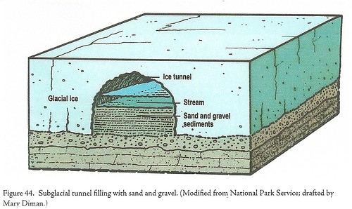 An esker is formed in warm glaciers where flowing water melts upward into the ice instead of downward into the bed. The flowing stream fills the tunnel with sand and gravel. Most eskers generally parallel the direction of the ice flow. They form near the edge of glaciers where the ice is relatively thin and is not moving fast. When the surrounding ice melts away, it leaves a ridge. Melt water was confined by surrounding ice which caused the deposits of sediment to be left above the surrounding terrain.
Mickelson, David M.. GEOLOGY OF THE ICE AGE NATIONAL SCENIC TRAIL.. ©2011 by the Board of Regents of the University of Wisconsin System, Reprinted by permission of the University of Wisconsin Press.
Eskers range from a few feet to over 150 feet high, from hundreds of feet to many miles long, and up to as much as a half mile wide with steep sides. The ridge crests of eskers are usually not level for very long; they are generally knobby. They are more abundant in areas where the glacier was slow moving or stagnant with a supply of debris at or near the glacier base. Eskers are generally composed of coarse sand and gravel, but they can be made of boulders at one extreme or fine-grained clay, silt, and sand at the other extreme.
Esker deposits of cobbles and boulders are left behind in high-flow areas. Slow-flow rates leave eskers of fine sand or silt. The slower the stream, the greater the chance for deposits. Many eskers are not continuous because sediment was deposited only in places where the meltwater slowed down.
 IATCC is the cache designation to highlight a series of EarthCaches along the Ice Age National Scenic Trail grouped into a special category called "ColdCache."
The Ice Age Trail is one of eleven National Scenic Trails designated by the National Park Service. This unique trail is entirely within the state of Wisconsin and follows along the terminal moraine of the most recent glacier which retreated about 10,000 years ago.
This project is supported by the Ice Age Trail Alliance (IATA). The goal is to bring more visitors to the trail and promote public awareness, appreciation, and understanding of Wisconsin’s glacial landscape.
The IATA has created an awards program to encourage visits to the trail and ColdCache sites. This awards program is separate from, and in addition to, any other Geo- or EarthCache awards program.
A current list of approved ColdCache sites can be found on the “IATCC Bookmark List”. More information on the Ice Age Trail Atlas, the Companion Guide, the ColdCache Project and Awards Program can be found on the “ColdCache Webpage”
Resources
GeoCache GC1X75Z – Eskers: Ancient Glacial Riverbeds
Geology of the Ice Age National Scenic Trail; by David M. Mickelson, Louis J. Maher Jr., and Susan L. Simpson
Wikipedia
Permission
The ColdCache Placement Authorization Form has been submitted to Tim Vetter of the Chequamegon National Forest. Thomas A Meyer, Conservation Biologist with the Wisconson State Natural Areas Program has also approved this EarthCache via e-mail. Geocaches placed on Wisconsin Department of Natural Resource managed lands require permission by means of a notification form. Please print out a paper copy of the notification form, fill in all required information, then submit it to the land manager. The DNR Notification form and land manager information can be obtained at: www.wi-geocaching.com/hiding
To claim this find:
As you walk on the esker, make note of the height, width, and curves.
1. Estimate the height and width of the esker at points A and B. Which is higher and how much of a difference is there?
2. Are there many curves or significant changes of direction? Based on this information, what was the general direction of the ice flow?
3. Is the north or south "half" of the esker more variable, (eg: height / width)? Does this information provide any clues to the water flow at either end?