Before logging this as found, cachers must read the lesson, perform the required tasks, and answer the questions below. Answers can be submitted by e-mailing the cache owner through his profile page. This earthcache may be difficult to complete in winter. ALTHOUGH THE GROUND IS SAFE TO WALK AND CLIMB ON, PLEASE EXERCISE GREAT CAUTION AS YOU MOVE ABOUT. Follow signs to the parking lot. Round-trip hike from there is around 2 km.
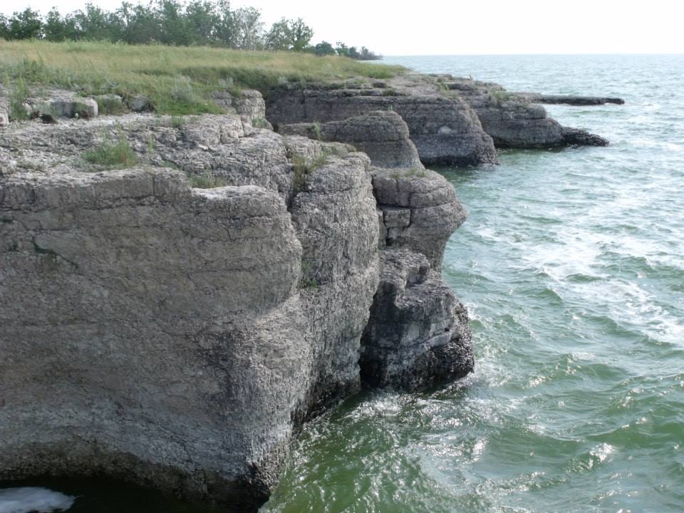
The village of Steep Rock, Manitoba is a jewel of the Interlake region. It is here, on the eastern shore of Portage Bay in the northeastern arm of Lake Manitoba, that millennia of erosive forces have produced some of the most stunning rock formations in the province.
Steep Rock is known for its steep-walled limestone cliffs, from which the village derives its name. Interspersed amongst these cliffs are other rock features including cracks, caves, and stacks, which have formed over time by the continuous erosive effects of wind, ice, and especially waves. Limestone is an ideal rock for enabling these features to form, as its hardness (“medium”) is most conducive to the required pattern of erosion. (Less hard rocks (e.g. lithified clay) erode too quickly, while harder rocks (e.g. granite) erode in a different manner.)
Cracks, caves, and stacks are all representative of different stages in the erosion process, and each of these stages can be observed at Steep Rock.
The first stage in the erosion process is the formation of a crack. This may be caused by the continuous pounding of waves on the cliff face, or by wind, ice, or even human activity. Whatever the cause, the crack becomes a weak point in the rock, making it more susceptible to further erosion. Wave (i.e hydraulic) action compresses air along the cliff face, exerting pressure on the rock and causing splintering. As these particles fall into the water, they intensify the waves’ erosive power by scraping against the rock – a process known as abrasion. Cracks can also form around vertical fractures, which are formed when stress on the rock mass exceeds its strength, causing the rock to lose cohesion at its weakest point. These fractures may extend through the entire height of the cliff face.
Over time, erosion causes cracks to grow, which results in the collapse of rock into the water and the formation of a cave – the next stage in the erosive process. Further hydraulic action expands the size of the cave. In a location with multiple cracks in close proximity, multiple caves may form simultaneously and merge. When the merger of caves occurs at a point back from the edge of the rock, an arch is formed. At some point, the rock arch above the caves can no longer be supported, and the arch collapses. The rock column that remains is now isolated from the mainland, and a stack is formed. See the diagram below for a visual description of this process (the process is the same in fresh or saline water).

The final stage in the erosion process (for the purposes of this earthcache) occurs as a result of further erosion on the stack. Just as with the original cliff, hydraulic action will wear away at the rock column, causing it to lose mass. As the base of the stack is assaulted, the upper sections of rock lose support and over time will collapse into the water below. A stack that has been reduced in size as a result of erosion and collapse is called a stump. The older a stump is, the shorter it will be.
Sources:
- http://www.bbc.co.uk/schools/gcsebitesize/geography/coasts/erosional_landforms_rev3.shtml
- http://www.geography-site.co.uk/pages/physical/coastal/stacks.html
- http://en.wikipedia.org/wiki/Coastal_erosion
- http://en.wikipedia.org/wiki/Stack_(geology)
- http://en.wikipedia.org/wiki/Fracture_(geology)
-------------------------------------------------
To log this earthcache as found, first e-mail me the answers to the following questions (don't post them in your log!). You may log it as found before hearing a response from me, but e-mails with missing or poor answers to the first three questions may be deleted, and the cacher notified as to the reason(s) why.
1. At the posted coordinates, observe the rock columns to the west. Compare the height of these columns with that of the ground you’re standing on. Do you think these stacks are newer, or older (i.e. stumps)?
2. Make your way south to N51° 26.529' W098° 48.357'. Here, at the edge of the cliff, you can observe a vertical fracture in the rock, which may one day result in the formation of a new cave below. Measure or estimate the width (less than shoulder width) and height of this fracture. (For the height, get an elevation reading at this spot and at any point along the edge of the water, such as a nearby beach.)
3. Continue further south to N51° 26.420' W098° 48.421'. A path leads down to the water’s edge. From here you can observe two caves in a small inlet. (Their entrances can also be seen from above from the north, but the full effect can only be seen from below.) Given enough time, do you think a new stack will form at this location? Why or why not?
4. (Optional) Post a photo of yourself and your GPSr, with the island or a pebbled ("shingle") beach in the background. Please do not post photos of the features at the posted coordinates or any other official waypoints (i.e. no photos of the stacks, fracture, or caves please).
| I have earned GSA's highest level: |
 |
FTF: JB., ruylopez, and rurbonas