“From below, Grand Mesa appears as a uniform flat mesa but it is actually in the shape of a Y with the base of the Y pointing east. Two long arms of basalt extend to the west high above the valley below. The molten lava that forms the cap rock of Grand Mesa was not violently ejected from a volcano; but flowed from vents down the course of pre-existing drainage. Gradually, the channels filled with lava which cooled and hardened to a resistant rock called basalt. Regional erosion of the prehistoric landscape cut down through the less resistant sediments, leaving behind the more resistant basalt. The result is an example of inverse topography; the low valleys where the lava flowed are now preserved as a mesa high above the modern valley floor.” Geological Road Log of Grand Mesa compiled by Nancy B. Laman, P.G.
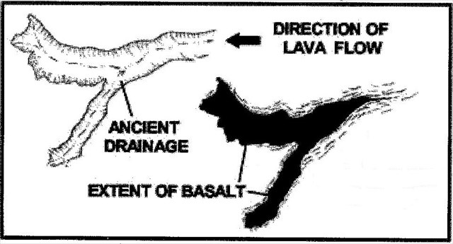
“Grand Mesa is formed by thick layers of basalt lava that flooded the ancient landscape. The magma welled up from cracks, or fissures in the earth somewhere east of the mesa. Long after the lava flow cooled, erosion over the ages stripped away the rock that flanked the mesa, leaving the basalt capped mesa to stand tall as a mountain.” Hiking Colorado’s Geology by Ralph Lee Hopkins and Lindy Birkel Hopkins
As you look north from GZ you see an excellent example of the exposed face (scarp) of the basalt cap with a talus slope below. The basalt lava cap across the top of Grand Mesa varies between 200’ to the west and, in the lower areas of the ancient drainage, 800’ thick to the east - towards the area of lava origination near Crater View - the same magma source that formed the West Elk's area.
You may log your find immediately but to complete the process you must answer the following questions and e-mail them at the same time to TEAM kekj . Please do not post the answers in your log: It will be deleted!
1. At this site, how many feet of the basalt cap would you estimate is exposed?
2. What are two names for the holes that released magma onto Grand Mesa?
3. What basic color is the basalt scarp in this view?
Parking available on wide shoulders of dirt road at GZ.
The talus below the scarp north of GZ is composed of large blocks of the basalt that have split off due to a combination of undercutting of the softer sedimentary base by erosion and/or freeze thaw cycles. This process is defined as “Mass Wasting”. In the small road cut immediately across the road and slightly to the East (right) you can see some of the light tan colored sedimentary rock (called - Claystone) that underlies the basalt cap. As it is much softer it erodes and spalls away much faster, undermining & hastening the mass wasting process.
Another process is also involved here called “Slump Block Failure”. You are standing on one of the more massive failures in the area. Look for the other area Earthcaches which explain these processes.
We would like to acknowledge the support of the rangers at the Grand Mesa National Forest Visitor Center, in particular the resident geologist, Mike Wiley, for having provided help, comments, and review in setting this Earthcache.
Co-FTF Congrats go to Pauleefox and Rojo464 on 10-7-14