GZ will bring you to an example of the basalt that makes up this region, please be very careful here as it can get very slippery. During the dry season you will be able to see bare rock that is usually behind the waterfall. Follow safety warnings at all times.
TO LOG THIS CACHE
To claim a find please email your answers to me via the GC.com website (PLEASE DO NOT POST YOUR ANSWERS IN YOUR LOG). There is no need to wait for confirmation before logging, if there is a problem with your answers I will get back to you.
1) Describe the surface of the rocks at GZ. Are they smooth or rough? Why do you think they might be this way, what caused it? YOU DO NOT HAVE TO APPROACH THE EDGE TO GET THESE ANSWERS
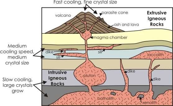
2) Did these rocks go through an intrusive or extrusive process when they formed? What are the differences in these types of rocks once cooled?
3) Take and post an optional picture of yourself or your GPS at this spot or anywhere else at the falls.
WHERE THE BASALT CAME FROM
150-200 million years ago during the Jurassic or Upper Karoo Period, when the present-day land masses forming South America, African, India, Australasia and Antarctica were all joined as one huge super-continent known as Gondwanaland, tectonic activity caused a break up of this landmass, with huge cracks or fissures forming in the earth's crust from which erupted huge volumes of molten basalt.
From Kazungula on the Botswana border to the Matetsi river, an isolated area of this basalt remains exposed, over which the present-day Zambezi flows and has cut its path, forming the falls and gorges. see Earthcache 'Great River' to learn more about the formation of the Zambezi River. The depth of the basalt is not known, perhaps up to 1,000 metres - but at least 300 meters in depth at the Falls region.
As the molten eruptions slowed and stopped, and the region stabilised, the central area of southern Africa subsided, perhaps under its own weight, to form what is often described as an inverted dish effect, with a raised border around most of the coastal areas and a shallow depressed central area forming a vast internal drainage network across what is known as the Southern African Plateau. Most of this ancient plateau is now heavily eroded, but in areas the flat-topped hills which are left by the erosive processes are isolated remnants of the original plateau.
After this period, there is a long gap of over 100 million years during which the geographic record tells us little or no information, when any deposits which may have formed over the basaltic surface have been completely eroded and removed. Only after this time did deposits begin to accumulate and over these today sits a thick mass of unconsolidated reddish, Kalahari sand that was formed under desert conditions and wind blown across the majority of the southern continent. These sands flank the wide and shallow Zambezi valley above the Victoria Falls, the river bed sitting on the exposed basalt rock. Downstream from the Falls the river valley continues in the same manner and height, with the gorge cutting deep into the old basalt bed of the river. (See EarthcacheThe Cataract for more information on the gorges)
WHAT IS BASALT
Basalt is volcanic rock, formed of molten lava that erupts from a volcano or in this case, fissures in the earth's crust. Basalt is an almost black, fine-grained rock. The molten rock (or magma) from which it is formed has a high proportion of minerals such as feldspars and these are responsible for the dark colour of the final rock. The thickest layers of basalt often result from molten lava flowing up great fissures in the crust. These flows cool rapidly as the lava spreads out over the surface and this rapid cooling causes the fine grain as many crystals start to form but none gets the chance to grow large.
Although basalt is usually grey to black in colour, it rapidly weathers to brown or rust-red, due to oxidation of its mafic (iron-rich) minerals into rust. So although usually characterised as "dark", basaltic rocks exhibit a wide range of shading due to regional geochemical processes, some even appearing light in colour.
USES
Basalt is most commonly used during construction projects. It can be used as aggregate in asphalt and concrete pavements. It is also used as a road base, railroad ballast and cobblestone pavement. Basalt may be cut into thin slabs and used as monuments, building veneers or floor tiles.
Be aware that the river flow varies from month to month and depends of the rainfall that has occurred in the upper Zambezi. The graph below gives you an idea of the average flow rate and when best to view the falls.
During the dry season the view is more likely to look like this.