MOR-Y03-005, Utterinvuori, Hauho EarthCache
MOR-Y03-005, Utterinvuori, Hauho
-
Difficulty:
-

-
Terrain:
-

Size:  (other)
Please note Use of geocaching.com services is subject to the terms and conditions
in our disclaimer.
(FIN) Earthcache joka esittelee Utterinvuoren moreenimuodostuman Hauholla.
(ENG) Earthcache that introduces Utterinvuori morraine formation at Hauho.
 tämä on Earthcache joten et löydä paikalta kätkölaatikkoa tai logikirjaa tähän kätköön liittyen. Tällä Eartcachella käynti osoitetaan suorittamalla kätkökuvauksessa kerrotut tehtävät. Eartcacheen eli maakätköön kuuluu oleellisena osana kohteen geologiaan liittyvä opetuksellisuus.
 This is an Earthcache so you won't find any items, box, physical cache or logbook at this site. you can log you visit by doing given tasks. Each EarthCache provides educational notes about current place geology.
 MOR-Y03-005, Utterinvuori, Hauho
MOR-Y03-005
(skip to English section.)
Huomioithan että tämä geokohde sijaitsee yksityisen mökkikylän alueella, mutta sille on omistajan lupa. Esimerkiksi parkkipaikaksi merkitylle pysäköintialueelle asti on siis lupa tulla omalla autolla. Liikuthan alueella kuitenkin kunnioittaen mökeissä majoittuvien rauhaa.
Drumlinin muodostuminen
Drumliinit eli moreenimäet ovat Suomen merkittävin moreenimuodostumatyyppi, jos otetaan huomioon muodostumien lukumäärä, niiden levinneisyys ja niiden koko. Ne ovat syntyneet niinsanotussa drumlinisaatiossa, joka tarkoittaa sitä että jäätikön pohjan esteet kuten kalliokohoumat ja muut lujat maaperän kerrostumat vaikuttavat jään alla tapahtuviin virtauksiin ja sen liikuttamien massojen liikkeisiin. Drumlinisaatiossa jäätikön alla olevat maamassat kerääntyvät näiden esteiden perään. Jään vaikutuksen jatkuessa syntyneet muodostumat muokkaantuvat edelleen, liikkuvat toisaalle, kuluvat ja uudelleenkerrostuvat (katso kuvat). Tutkimuksien perusteella yksittäinen noin 10 metriä korkea drumliini voi syntyä jäätikön pohjalle noin kymmenen vuoden kuluessa. On siis kuitenkin mahdollista, että voimakkaan virtauksen alueella yksittäinen drumliini saattaa muuttaa muotoaan, kokoaan tai jopa hävitä kokonaan. Drumliinien muodon perusteella voidaan tehdä päätelmiä jäätikön virtauksesta niiden synnyn aikana. Esimerkiksi pitkät ja suhteellisen kapeat drumliniselänteet ovat syntyneet pitkäaikaisen liikkeen vallitessa, kun virtaukset ovat pystyneet muokkaamaan jäätikön alustaa pitkään, samansuuntaisesti ja hyvinkin voimakkaasti. Drumliinien syntymisen jälkeenkin tapahtuneet muutokset jäätikön virtaussuunnissa näkyvät niiden muodossa. Uusi liikesuunta saattaa muodostaa moreenin pinnalle erillisiä uuden suunnan mukaisia pienempiä drumliineja tai aikaisemmin syntynyt moreenimäki saa koukkumaisen muodon.
Usein drumliinikentät eli tiheät drumliiniesiintymät alkavat noin 10–30 kilometriä isojen reunamuodostumien sisäpuolelta ja jatkuvat jopa 100–200 kilometriä. Drumliinien välisiin laaksoihin tai jopa suoraan niiden päälle syntyneet reunamuodostumat eli harjut ja muut jäätikön sulamisvesiin liittyvät kerrostumat osoittavat että moreenimäet ovat syntyneet ennen jäätikön reunaosan perääntymistä niiden alueelle. Drumliinien koko vaihtelee suuresti. Niiden pituus voi vaihdella alle sadasta metristä jopa useisiin kilometreihin ja leveys jalkapallokentän leveydestä niin ikään useisiin kilometreihin. Drumliinien korkeus voi puolestaan vaihdella metristä jopa pariin sataan metriin.
Lähteiden esiintyminen
Luonnonlähteitä muodostuu kun sadevesi imeytyy harjuun, moreenimäen rinteeseen tai muuhun maaperässä olevaan huokoiseen osaan muodostaen pohjavettä. Kun tämä maaperässä eri maalajien sisällä tai peruskallion raoissa virtaavan pohjaveden pinta sitten leikkaa maanpinnan tason (katso kuvat) muodostuu lähde. Lähde voi olla muodostunut useasta silmäkkeestä eli olla niinsanottu allikkolähde, se voi olla pelkästään tietyssä kohdassa maan pinnalle vettä tuottava tihkupinta, heikosti havaittava hetteikkö tai niinsanottu purolähde. Purolähde alkaa siitä mistä pohjavesi purkautuu maan pinnalle, allikkolähteessä taas pohjavesi purkautuu ensin pieneen vesialtaaseen, josta lähtee puro. Hetteikkölähteessä vesi ikäänkuin tihkuu maanpinnan läpi. Hetteikkölähde voi usein olla myös moniosainen ja -altainen lähteikkö.
Siirtolohkareet
Siirtolohkareet ovat kalliosta irronneita isoja kiviä, jonka jääkauden aikainen mannerjää on kuljettanut mukanaan usein jopa hyvinkin kauas emokalliosta. Alavilla alueilla siirtolohkareet ovat usein peittyneet muun maa-aineksen alle, mutta maastossa korkealla paikalla kuten harjujen rinteissä tai moreenimäissä kivet ovat monesti säilyneet näkyvillä. Heikomman kiviaineksen alueilla siirtolohkareet voivat olla hioutuneita ja sileitä.
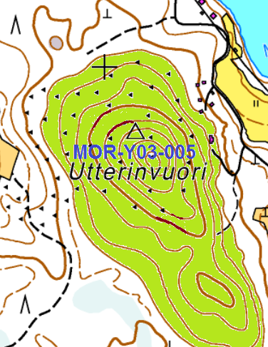
Utterinvuoren drumliini
Kuten Drumliinit yleensä Utterinvuorikin on suuntautunut jäätikön liikkeen mukaisesti. Muodostuma on ilmeisesti syntynyt muinaisen mannerjäätikön liikkeen suuntautuessa kohden I Salpausselän vyöhykettä tai jo tätä ennen, kun jää on virrannut johonkin kauempana olleeseen jäätikön reuna-asemaan. Muodostuman lähtökohtana on todennäköisesti ollut kookas jäätikön alla ollut moreenikumpu, koska seudulla esiintyy muita vastaavia jääkautta edeltäneitä moreenikumpuja, eikä Utterinvuoren proksimaaliosassa ei ole näkyvissä isoja kallioalueita. Utterinvuoren rinteillä on löydetty rantapenkereitä joista ylimmän rannan taso on noin 140 metriä nykyisen merenpinnan tason yläpuolella. Drumliinin rinteet ovat selkeät ja muodostuma on melko iso. Rinteet ovat lisäksi varsin jyrkät. Koko drumliinin muoto on siis selkeä ja ympäristöstään helposti hahmottuva.
Jotta voit kirjata tämän kätkön löydetyksi sinun
täytyy suorittaa seuraavat tehtävät annetuissa koordinaateissa:
1 )
Tämän Geokohteen boguspiste N 61° 11.651 E 024° 36.120 sijaitsee Utterinvuoren Drumlinin huipulla.
a) Tee havaintoja kulkiessasi vuoren laelle ja päättele alueen pinnanmuodoista Jäätikön alla olleiden virtojen etenemissuunta. Mihin havaintoihin perustat vastauksesi?
b) Kuinka iso Utterinvuoren drumlini on (leveys, pituus ja korkeus metreissä)?
2 )
Jäätikön vaikutuksesta on alueella myös muita todisteita,
esimerkiksi koordinaateissa N 61° 11.801 E 024° 36.075 ja
N 61° 11.608 E 024° 36.605.
(viitepisteet 1 ja 2)
a) Mitä nämä ovat ja miten ne liittyvät jäätikön liikkeisiin?
b) Miksi ne ovat päätyneet juuri tähän ja miksi ne ovat täällä helposti havaittavissa?
3 )
Koordinaateista N 61° 11.892 E 024° 36.168 , (viitepiste 3)
löydät alueen geologiaan liittyvän muodostuman/ilmiön.
a) Minkä tyyppinen muodostuma on kyseessä?
b) Miksi näkemyksesi mukaan ilmiö esiintyy juuri tällä paikalla?
c) Kuinka syvä kyseinen ilmiön esiintymä on?
d) Kuinka ihminen on tehostanut ilmiön hyötykäyttömahdollisuutta?
4 )
Lähetä vastauksesi kätkön omistajalle vaikkapa tällä viestilinkillä tai sivun yläreunan viestikeskuslinkillä
Kirjoita viestin otsikoksi MOR-Y03-005
(ps. jos valitset viestin alta "I want to send my email address along with this message" vastaamiseni helpottuu)
Sinun ei tarvitse odottaa kirjauslupaa, mutta asiattomat kirjaukset tullaan poistamaan. Omistaja vastaa jollain aikavälillä viestiin, jos vastauksissa on epäselvää.
5 )
Toivottavaa on myös että otat valokuvan itsestäsi ja/tai gps laitteestasi Utterinvuorella, tai jossakin kirjaustetävään liittyvässä viitepisteessä ja liität sen kirjaukseesi.
lähteet:
http://www.geologia.fi/index.php/2011-12-21-12-30-30/2011-12-21-12-39-11/2011-12-21-12-39-51/moreeni
https://helda.helsinki.fi/bitstream/handle/10138/43575/MOR-Y03-005.pdf?sequence=1
http://fi.wikipedia.org/wiki/L%C3%A4hde
http://fi.wikipedia.org/wiki/Siirtolohkare
MOR-Y03-005
Please be aware that this earthcache is located in a private area of holiday cottages, but it has the landowner's permission. You are allowed to come by car as far as the area marked as a car park. Please respect the peace and privacy of any cottage residents.
Drumlin formation
Drumlins or moraines are Finland's commonest moraine formation type, considering their number and size, and the extent of their occurrence. They are formed in so-called drumlinisation, which means that obstacles under the ice field, like bedrock protrusions and other solid earth layers, influence flows beneath the ice and the movements of masses being moved by the ice. In drumlinisation the earth masses under the ice field gather behind these obstacles. As the ice continues its movement, the formations are reshaped, moved to a new location, are worn away or form new layers (see photos). Based on studies a single drumlin with a height of about 10 metres can form under the ice field during a period of ten years. It is therefore possible that in an area with a strong flow a single drumlin can change its shape, its size, or even disappear altogether. Based on the shape of drumlins we can draw conclusions on the movement of the ice during their formation. For example long and relatively narrow drumlin ridges are formed during long periods of movement, when flows have been able to significantly shape the underside of the ice field, always in the same direction and over a long period of time. Changes in the ice field's direction of movement can be seen in the shape of drumlins even after they have been formed. The new direction of movement forms new smaller drumlins on the surface of the moraine in the same direction as the ice movement, or a previously formed moraine hill can acquire a hook shape.
Drumlin fields or drumlin formations usually start from 10-30 kilometres inside large terminal moraines and continue for 100 or even 200 kilometres. Terminal moraines or ridges and other layers related to ice field melt water erosion, which have formed in the valleys between drumlins or even directly on top of them, indicate that moraine hills are formed before the ice field's edge retreats into their area. The size of drumlins varies considerably. Their length can vary from under 100 metres to several kilometres, and their width from that of a football field to several kilometres. Their height varies from around one metre to up to a couple of hundred metres.
The occurrence of springs
Natural springs form when rainwater soaks into a ridge, the side of a moraine hill or other porous part of the soil, and becomes groundwater. When this groundwater flows through the soil or cracks in the bedrock and emerges at the surface of the ground, a spring is formed (see photos). A spring may be formed of several seepage points welling up into the same pool, a single spot where water emerges to the surface, a hardly noticeable quagmire or a so-called stream spring. A stream spring starts where the groundwater emerges to the surface. In a pool spring on the other hand the groundwater first emerges into a small pool or pond, from which a stream flows. In the case of a quagmire the water kind of weeps through the ground to the surface. A quagmire can often be a multi-pooled spring.
Erratic boulders or glacial erratics
Erratic boulders are large rocks or boulders broken off from the bedrock and carried by glacial ice often over long distances from their origin. In low lying areas they are often covered by other materials, but on higher ground like ridges or moraines they are exposed and in full view. In areas where the rock is softer erratic boulders can have smooth surfaces.
Utterinvuori drumlin
As with drumlins in general the Utterinvuori drumlin is aligned with the movement of the ice field. The formation is clearly the result of the ice sheet's movement in line with the first Salpausselkä ridge or even before that, when the ice has flowed towards a more distant periphery of the ice field. The origin of the formation is probably a sizeable moraine mound, because there are similar moraine mounds in the region from before the last ice age, and there is no sign of any rocky areas on Utterinvuori's proximal or inner side (in relation to the ice field). Ancient shore lines have been found on the slopes of Utterinvuori where the highest is about 140 metres above the present sea level. The drumlin's slopes are clearly visible and the formation is relatively large. The slopes are also quite steep. The overall shape of the drumlin can be clearly seen and is easy to distinguish from its surroundings.
To log this cache you must do following tasks in given coordinates:
1 )
This earthcache's bogus point N 61° 11.651 E 024° 36.120 is located on the top of the Utterinvuori drumlin.
a) As you climb to the top, try to determine from the shape of the surface the direction of flow of streams under the ice field. What is the direction and on what observations do you base your answer?
b) How big is the Utterinvuori drumlin (length, width and height) in metres?
2 )
There is other evidence of the ice field's impact on the area, for example at coordinates N 61° 11.801 E 024° 36.075 and N 61° 11.608 E 024° 36.605. (reference points 1 and 2)
a) What are these and how are they connected to the movement of the ice field?
b) Why have they ended up here and why are they so visible?
3 )
At coordinates N 61° 11.892 E 024° 36.168 , (reference point 3) you will find a formation/phenomenon relating to the area's geology.
a) What kind of formation is it?
b) Why in your opinion does the phenomenon appear here precisely?
c) How deep is this example of the phenomenon?
d) How has man increased the usefulness of this phenomenon?
4 )
Send your answers for example via this message link)or via messagecenter (link at the top of this description) to the cache owner.
Title your post “MOR-Y03-005”
(ps. if you enable selection "I want to send my email address along with this message" it is easier for me to reply)
You don't have to wait for a logging permission, but any incomplete logs will be deleted. Cache owner will reply something for post if there is some faults in answers.
5 )
It is hoped that you take a photo of yourself and / or your GPS device at the top of the Utterinvuori or at some of the reference points and then paste it to your log.
sources:
http://www.geologia.fi/index.php/2011-12-21-12-30-30/2011-12-21-12-39-11/2011-12-21-12-39-51/moreeni
https://helda.helsinki.fi/bitstream/handle/10138/43575/MOR-Y03-005.pdf?sequence=1
http://fi.wikipedia.org/wiki/L%C3%A4hde
http://fi.wikipedia.org/wiki/Siirtolohkare
Kiitokset, special Thanks:
translation By Gandal491. Many thanks for your help.
 Jaakko Pouttu, Leppäniemen Hirsihuvilat
- Maitomies -
you can also contact cache owner via facebook:

Additional Hints
(No hints available.)