A hugh glacier advanced into the Chippewa Moraine area 12,000 to 18,000 years ago. Glacial drift (sand, gravel, rock, and boulders) were deposited at the edges of the glacier forming moraines.
The Chippewa Lobe of the Laurentide Ice Sheet ended about 1.5 miles southwest of the Interpretive Center. The Center is on top of an ice-walled-lake-plain, which is a former lake bottom.
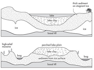 An ice-walled lake plain forms when the glacier acts as the walls of a container to hold water dammed in a complex of debris-covered ice. The lake sediment accumulates with fine-grained sediment of clay, silt, and sand carried to the more central, deeper parts of the lake. These deposits become stratified into thin layers, often less than 1 inch thick. Course sediment of sand and gravel accumulated around the edge of the lake as it slides off the surrounding ice.
When the ice walls containing the lake have completely melted away, the lake sediment stands as a relatively flat-topped hill that is higher than the surrounding area .
Graphic reprinted by permission of the University of Wisconsin Press from GEOLOGY OF THE ICE AGE NATIONAL SCENIC TRAIL, by Mickelson, David M.. ©2011 by the Board of Regents of the University of Wisconsin System,
Many ice-walled lake plains have a dish-shaped surface with the course material deposited near the ice wall forming a rim ridge around the lake plain. They are commonly roughly circular areas of a mile or more across.
 IATCC is the cache designation to highlight a series of EarthCaches along the Ice Age National Scenic Trail grouped into a special category called "ColdCache."
The Ice Age Trail is one of eleven National Scenic Trails designated by the National Park Service. This unique trail is entirely within the state of Wisconsin and follows along the terminal moraine of the most recent glacier which retreated about 10,000 years ago.
This project is supported by the Ice Age Trail Alliance (IATA). The goal is to bring more visitors to the trail and promote public awareness, appreciation, and understanding of Wisconsin’s glacial landscape.
The IATA has created an awards program to encourage visits to the trail and ColdCache sites. This awards program is separate from, and in addition to, any other Geo- or EarthCache awards program.
A current list of approved ColdCache sites can be found on the “IATCC Bookmark List”. More information on the Ice Age Trail Atlas, the Companion Guide, the ColdCache Project and Awards Program can be found on the “ColdCache Webpage”
DNR Permission
The Geocache Notification Form has been submitted to Brenda Rederer of the Wisconsin DNR. Geocaches placed on Wisconsin Department of Natural Resource managed lands require permission by means of a notification form. Please print out a paper copy of the notification form, fill in all required information, then submit it to the land manager. The DNR Notification form and land manager information can be obtained at: www.wi-geocaching.com/hiding
Resources
Geology of the Ice Age National Scenic Trail; by David M. Mickelson, Louis J. Mahler Jr., and Susan L. Simpson
Roadside Geology of Wisconsin; by Robert H. Dott, Jr and John W. Attig
To claim this find
1. Estimate how much of an elevation change there is from the interpretive sign on the Ice Age Trail to the top of the ice-walled-lake-plain. Estimate how much of an elevation change is there from the Ice Age Trail to the bottom at this location.
2. Assume that the lake sediment accumulated at the rate of 0.25 inches per year. Based on the estimated height of the IWLP, approximately how long did it exist before the surrounding ice melted?