The site is much more than the summary. It is a spectacular combination of geological features, spread over approximately 8 miles of Lake Superior Shoreline southwest of Copper Harbor. It includes a dramatic section of the Keweenaw Thrust Fault, the Keweenaw’s finest white sand beach: a low energy shallow area frequently sheltered from the strong NW winds that batter the N and NW shorelines. The beach is bisected by a human-engineered waterway that connects the Big Lake with Lac La Belle. South of this beach is a shelf of Jacobsville Sandstone which slopes gently into the lake, providing many areas of exploration of redbed sandstone (http://www.geo.mtu.edu/KeweenawGeoheritage/Sandstone/Reading.html)features, including crossbedding, potholes, ripple marks, mudcracks, clay inclusions, fluvial channels and other features. Access to these ledges depends on favorable weather, winds and wave action. Shallow cliff exposures occur sporadically as well, providing vertical exposures in the generally flat-lying sandstone.
The exact GPS location is a parking spot for Bete Grise South Preserve (http://www.keweenawlandtrust.org/special-betegrise.php), which marks the beginning of a walking exploration. To experience the raised shorelines, walk the trail north of the parking spot 130 meters to the present shoreline(N 47° 21.642 W 87° 57.641). Turn left and walk north about 500 meters along the beach(N 47° 21.874 W 87° 57.841). Then walk away from the beach to encounter low sandy ridges only a few meters apart. These are closely spaced former sandbars. As you walk farther north toward the man-made channel (1100 m farther) these ridges are more widely spaced (10-20 m).

EarthCache Lesson: Several Earth science features are at this exceptionally beautiful site--we list them individually below.
Fault exposures: The Keweenaw Thrust Fault is a major fault that divides the entire Keweenaw Peninsula into two parts (Figure 2): A northward dipping ridge and valley region underlain by lavas and conglomerates and an area of much smoother topography underlain by flat-lying redbed sandstone. The Fault crosses the shoreline in several places along the steep shorelines that trend in an E-W direction east of the sandy beach and heading toward Keweenaw Point. In a kayak or canoe one can trace the fault in shallow water near the shorelines (Figure 3).
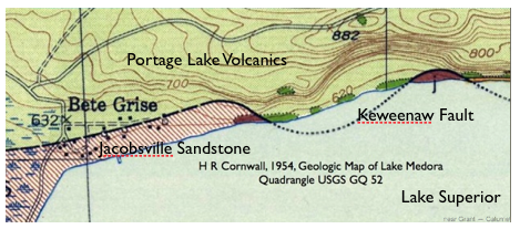
Figure 2: Geological map of shoreline along the N boundary of Bete Grise, showing places where the Keweenaw Fault crosses the shoreline. USGS Source.
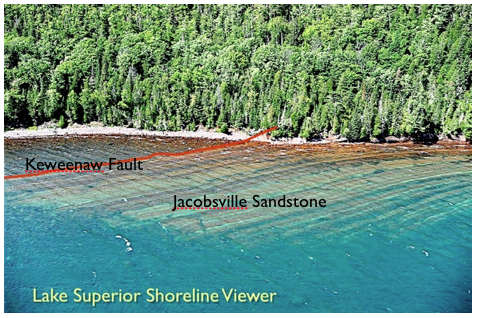
Figure 3: Aerial view of Bete Grise Shoreline, where Keweenaw Fault trace can be seeen through shallow water of Lake Superior.

Figure 4: Simplfied cross section across the Keweenaw Fault at Bete Grise, showing how the Portage Lake Volcanics are thrust upward, deforming and covering the Jacobsville Sandstone. (Source: http://www.geo.mtu.edu/KeweenawGeoheritage/Lake/Bete_Grise.html)
Low Energy Beach: Prized and appreciated as the Copper Country’s best beach, Bete Grise has a northern more popular section where cars may drive right to the Beach and where there are public rest rooms, and a quieter, more secluded part to the south (Bete Grise South). The two parts are separated by the dredged waterway (Figure 5) where boats can travel from the Big Lake into Lac LaBelle, past the Mendota Lighthouse.

Figure 5: Aerial View of man made channel which provides boat access from Lake Superior to La La Belle. The raised shorelines are exhumed sandbars which record the pattern of lake changes since glaciation. Apple Maps Source.
Raised Shorelines: A bathtub-ring-like relict of Lake History. Inland from Bete Grise shorelines are sandy ridges which preserve the shapes of old shorelines that prevailed at various times during glacial retreat (figure 5: http://www.geo.mtu.edu/KeweenawGeoheritage/Lake/Shorelines.html). These ridges may be exhumed sandbars which formed just offshore when lake levels were higher in the past. The patterns display shoreline patterns which defined former shore communities for humans during times of post-glacial lakes (the last 10,000 years) which arose from glacial retreat and melting. Sandbars on Lake Superior form in multiples of 2-5 (http://www.geo.mtu.edu/KeweenawGeoheritage/Lake/Sandbars.html) typically their spacing increases as the depth increases away from the shore.
The overall pattern of raised shorelines suggest that lake levels are falling with time. Geologists suggest that this is caused by evolution of lake outlets, which are eroding with time and the gradual rise of the land surfaces after the great weight of ice was removed (http://www.geo.mtu.edu/KeweenawGeoheritage/Lake/Isostasy.html).
Sandstone Sedimentary features: South and east of that beach is Pointe Isabelle, a dramatic headland of flat-lying Jacobsville Sandstone ledges with dramatic geomorphology that displays an ancient tombolo (Figure 6: http://en.wikipedia.org/wiki/Tombolo). The sandstone ledges can be seen through the clear waters of the lake as they are only a few feet below the lake surface for hundreds of yards from the shore. Spectacular potholes occur in the sandstone ledges (Figure 7).
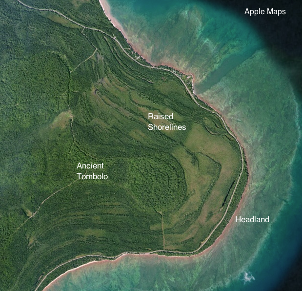
Figure 6: Vertical Aerial View of Point Isabelle Headland with its shallow sandstone ledges forming a surrounding rim and with raised shorelines inland. The headland also surrounds an ancient tombolo. Apple Maps source.
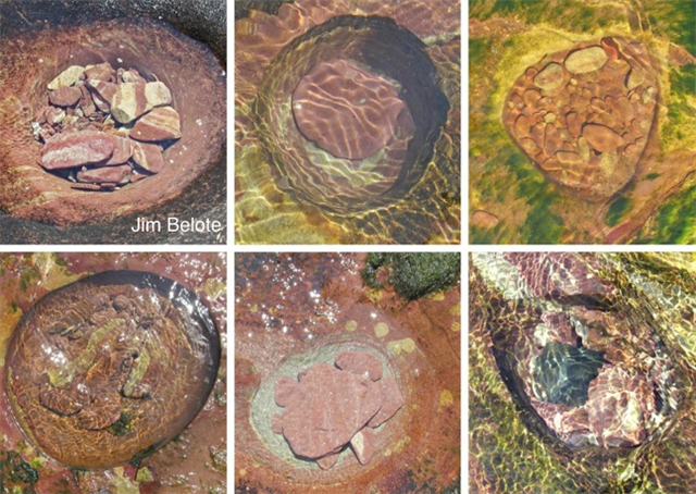
Figure 7: Potholes observed on the Sandstone ledges surrounding Point Isabelle. Many sandstone sedimentary features can be seen on these ledges. Jim Belote Photo, by permission. (http://www.geo.mtu.edu/~raman/SilverI/Sandstone/Pt_Isabelle.html)
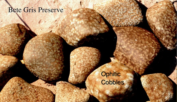
Figure 8: On the Bete Grise South Beach, one frequently encounters these cobbles. They have ophitic textures (http://www.geo.mtu.edu/KeweenawGeoheritage/BlackLavas/Ophitic_Texture/Ophitic_Texture.html), characteristic of slowly cooled lavas and sills, but which are quite rare on a worldwide basis. Source: http://www.geo.mtu.edu/KeweenawGeoheritage/The_Fault/B_Grise.html
Logging your visit:
Send an email to answer the following question:
What features can you see or sense at the current Bete Grise beach (including underwater) that resemble (or could be the same thing as) the “raised shorelines”? What is your estimate of the spacing and height of these features along the shore today? You may have to get in the water to answers these!
What are two indicators that Bete Grise South is a very low energy beach?
Earth Science Literacy Principles Big Ideas
Big Idea number 5- Earth is the water planet.
Visit http://www.earthscienceliteracy.org/es_literacy_22may09.pdf for more information on the Big Ideas. If you don’t sense the power of water at Earth’s surface here, then you are insensitive.
Bibliography:
Keweenaw Geoheritage: http://www.geo.mtu.edu/KeweenawGeoheritage
Image Permissions:
Figure 1: Map from Copper Country Scenic Byway website, Copyright © 2015
Western Upper Peninsula Planning & Development Region, permission for public use obtained for use of the map in EarthCache.
Figure 2: USGS geologic map, public use with attribution is permitted.
Figure 3: Lake Superior Shoreline Viewer, public use with attribution permitted. Figure 4: Made by Submitter.
Figures 5, 6: Apple Maps Images, public use with attribution permitted.
Figure 7: Photo by Jim Belote, Permission for use obtained.
Figure 8: Made by submitter.
EarthCache Site Permission: This site (Bete Grise South) is managed by the Houghton Keweenaw Conservation District, The Nature Conservancy and the Keweenaw Land Trust and is open for public access (see http://www.keweenawlandtrust.org/special-betegrise.php).
Contacts:
1. Gina Nicholas
Houghton Keweenaw Conservation District
711W. Lakeshore Drive - Unit A
Houghton, Ml 49931
906 482-0214
2. Evan McDonald
Keweenaw Land Trust
801 N. Lincoln Dr. Ste. 306
Hancock, MI 49930
906-482-0820