Imatrankosken voimalaitoksen läheisyyteen ns. Kruununpuiston alueelle on rakennettu n. 1 km pituinen kaupunkipuro. Kruununpuisto sijaitsee Imatran keskusta-alueen läheisyydessä ja alueella on myös merkittävä matkailuhistoriallinen nähtävyys, Imatrankoski. Kaupunkipuro jakautuu kahteen osa-alueeseen, maisemalliseen yläosaan, joka sijaitsee Imatrankosken voimalaitospadon ja Imatrankoskentien välisellä alueella ja luonnonmukaiseen alaosaan, joka käsittää Imatrankoskentien ja Vuoksen välisen osuuden. Puron alaosan toteutuksen lähtökohtana on kalataloudellisien seikkojen huomioiminen. Puron alaosa toteutetaan niin, että pyritään luomaan mahdollisimman hyvät olosuhteet taimenien poikastuotannolle ja poikasien menestymiselle. Matkailun näkökulmasta kaupunkipuro on vetovoimainen elämys, joka tuo uudella tavalla esiin alueen historiaa ja geologiaa. Puro kohentaa keskeisen puistoalueen näyttävyyttä ja luo alueelle uuden matkailun kannalta merkittävän elementin. Kalatalouden kannalta tavoitteena on lisätä alueella olevan taimenkannan lisääntymismahdollisuuksia.
(Lähde: GoSaimaa.com -sivusto)
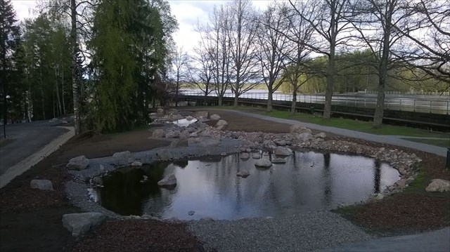
Kaupunkipuro saa alkunsa pienestä lammesta (kuva alapuolella), johon vesi johdetaan Vuoksesta maanalaisella putkella käyttämällä vanhaa tukinottorännin luukkua. The starting pond of the city brook (photo) into which the water is flowing underground (water pipe) from Vuoksi.
Reittipisteet:
Parkkipaikka N 61 10.106, E 028 46.483
1. N 61° 10.138 E 028° 46.533 - Paviljonki
Istahda hetkeksi katselemaan kaupunkipuron alkuosaa. Laske paviljongin valkoiset pylväät (A) ja keskipylvään ympäri kiertävät pienet valkoiset tukiraudat (B).
2. N 61° 10.183 E028° 46.562 - Musta aita
Puron pohjoispään lähellä on pieni musta aita, jonka takaa on kiva katsella vaikkapa koskinäytöstä. Kuinka monta selvästi erottuvaa kukkakuviota aidassa on? (C)
3. N 61° 10.138 E 028° 46.510 - Tunneli
Puro alittaa Imatrankoskentien tunnelissa. Kuinka monta paksua ja harmaata aidan pystytolppaa on tunnelin sisällä? (D)
4. N 61° 10.068 E 028° 46.453 - Silta
Täältä näet, miten puro ylittää ylisyöksyuoman. Sillan kaiteen kivitolppaan on kiinnitetty liikennemerkki. Kuinka monta pulttia kiinnitykseen on käytetty? (E) Läheisessä kyltissä on tietoa tukinuittorännistä. Kerro alkuperäisen uittokourun putouskorkeus luvulla 1,75. Saamasi luku on F. (F)
Huom! Kyseinen kyltti puuttuu, F=42
5.N 61° 10.007 E 028° 46.398 - Voimalaitos
Täältä näet voimalaitoksen etelänpuoleisen seinän. Kuinka monessa vierekkäisessä pystyrivissä (= seinän syvennys) voimalaitoksen seinässä on ikkunoita (laske syvennykset koko seinän leveydeltä)? (G)
6. N 61° 09.963 E028 46.247 - Puron alaosa
Täällä näet, miten kaupunkipuro mutkittelee ja laskee lopulta Imatrankosken vanhaan uomaan Vuoksessa. Kuinka monta jyrkkää, lähes päinvastaiseen suuntaan kääntyvää, mutkaa, puro tekee ennen Vuokseen laskemistaan? (Laske vain tästä näkyvät selkeät mutkat, älä puron alkupään mutkaa yläjuoksulla tai pieniä mutkia juuri ennen Vuoksea.) Vaihtoehdot: 1, 2, 4 vai 6? (H)
Kätkön koordinaatit saat sijoittamalla saamasi luvut kaavaan:
N61 A.BxCxH-5xA+2xD-5
E28 F+G-H-E.12xG+6xD:F+D-5
Kaupunkipuron leveys on 2-3 metriä. Kuva puron maisemallisesta yläosasta. The width of the city brook is 2-3 meters. The scenic upper course in the photo.
A multi cache near the new city brook build in 2014 on the old flowing stock route. Have a nice over half a kilometer walk near the brook and answer the questions. Please, stay on the walking route. The cache box is micro sized and includes a pen.
The new City Brook in Imatra within the vicinity of the Imatrankoski power plant in the Kruununpuisto (Crown Park) area, a kilometre-long City Brook has been built which brings the area's history and geology to the fore. The brook divides into a scenic upper course and natural lower course, which also has trout. (the source: GoSaimaa.com)
Parking N 61 10.106, E 028 46.483
1. N 61° 10.138 E 028° 46.533 - The pavilion
Sit down for a while and see the brook. Do count the white pillars in the pavilion (A) and the little white pillars around the middle pillar. (B)
2. N 61° 10.183 E028° 46.562 - The black fence
Near the northern end of the brook there is a small black fence. It's nice to view the rapids behind the fence. How many flower figures can you see in the fence? (C)
3. N 61° 10.138 E 028° 46.510 - The tunnel
The brook flows under the Imatrankoskentie in the tunnel. How many big and grey pilars of the fence can you see inside the tunnel? (D)
4. N 61° 10.068 E 028° 46.453 - The bridge
Here you can see how the brook goes over the power plant's overflow channel. There is a traffic sign in the stone pilar. How many bolts was used to connect the traffic sign with the stone pilar? (E) Near there you can find a sign giving infromation about log floating chute. Multiply the drop of original chute by 1,75 and you will get F. The sign is lost - F=42. (F)
5. N 61° 10.007 E 028° 46.398 - Power plant
Here you can see the southern wall of the power plant. How many vertical (niche, within the wall) window rows are there (count all the niches, within the wall forms in the southern wall)? (G)
6. N 61° 09.963 E028 46.247 - The natural lower course
Here you can see the curves of the city brook and the way it flows to the old channel of Imatrankoski and the Vuoksi river. How many steep and almost to the opposite direction turning curves the brook is having before flowing to the Vuoksi river? (Do count the curves you see near this area, do not count the first curve in the northern part of the brook or little curves just before Vuoksi) Alternatives: 1, 2, 4 or 6? (H)
You will get the coordinates for the cache with this formula:
N61 A.BxCxH-5xA+2xD-5
E28 F+G-H-E.12xG+6xD:F+D-5
Checkeri lisätty 24.10.2016

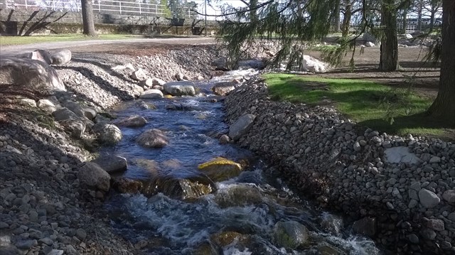
Puron alaosan mutkia kuvassa. Curves in the end of the brook (photo).
