
The published coordinates will take you to one of the highest points of the Durban Berea, some 128m above sea level. From this vantage point you have a magnificent view over the Durban city centre, the harbour and the bluff.
You may not know it, but you are standing close to the top of an ancient sand dune - The Berea Dune - the formation of which began some 65 million years ago.
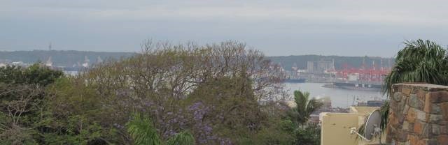
The View over Durban Harbour
Formation of the Berea Dune
During the Permian Period (299 - 251 MYA), the ancient continent of Gondwanaland moved closer to the equator. South Africa, at the heart of this landmass was covered by a large warm inland sea as part of the Karoo Basin. Thick silt and clay beds built up interspersed with the vegetative remains of swamp plants. These sediments hardened into Ecca Shale and are darkly-coloured from their carboniferous plant content. These shales break down quickly and easily when exposed to erosive agents. One can see these beds in Cato Manor, just inland from the Berea Dune, where they constitute unstable hillsides unsuitable for the building of homes.
During the Pliocene Period, approximately 5 million years ago, the sea level rose once again (as they had in earlier epochs) flooding over the Natal and Zululand plains, covering previous deposits and driving the shoreline well inland. As in previous inundations and marine depositions, the sea deposited beds of softer, lime-rich sand across the plain that hardened into vast beds of sandstone.
Towards the end of the Pliocene Period, the sea retreated in stages, and the previously laid-down beds of sandstone were exposed to weathering. These softer, friable rocks broke down quicker into loose sands than did earlier deposited rock beds like the Natal Group (Table Mountain Sandstone) and bands of Dwyka Tillite (a glacial sedimentary rock). This eroded sand was washed down the many streams and rivers into the ocean where wave and tide deposited the sand along the shoreline. During stages when the shoreline was relatively stationary, sea and wave action cut notches and cliffs into the coastal plain, and where the shoreline lingered, the loose sand piled up under wind action forming large dunes that ran parallel to the shoreline.
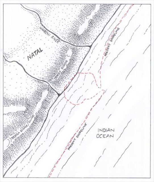
Cenozoic Shoreline
During the Cenozoic Period (from 65 MYA), following one of the oscillations of the KwaZulu Natal landmass, the coastal plain was raised, and the shoreline receded to a position approximately where Umbilo and Umgeni Roads in the city of Durban are today. The shoreline lingered long enough to cut cliffs into the raised land composed of earlier Pliocene marine beds.
Then winds began the gradual task of piling up a huge dune along this cliff, an impressive 65 metres of beach sand atop the rock bed of Natal Group, and Dwyka Tillite, Ecca Shale and Pliocene Marine that was at its highest 75 metres above the sea level. This created the Berea Dune/Ridge, a full 140 metres above sea level. From atop the modern Berea, this elevation is what affords residents fine views of the Indian Ocean, City, Bay and Bluff. Looking landward, the valley descends at approximately 30 degrees into a wide valley with its lowest reach approximately 1 kilometre away where the Umkumbaan River (a tributary of the Umbilo River) flows southwards.
From this point the land rises moderately towards the modern suburbs of Berea West, Westville and Queensburgh and the land is composed mostly of Ecca Shale. The Berea Dune runs from south of Durban all the way up to Mtunzini and at intervals well beyond. Just beyond Isipingo, it combines with the later Wentworth Dune, from where it runs in intervals further south.
The Natal Monocline
The many rivers that flow eastwards towards the sea carried sand and silt down to the coast. This erosion was increased when the landmass tilted to a steeper incline about 20 000 years ago. It is this tilting that resulted in rivers deeply eroding their courses into deep gorges inland from Durban, gorges like those at the Palmiet Nature Reserve and at the Krantzkloof Nature Reserve. It also resulted in the sea level dropping a full 120 metres below the present.
The rivers of Natal carry an abundance of sand down to the coast where the northerly littoral drift distributes the sand along the coast in a series of fine beaches. This sand is continually thrown-up onto the shoreline by wave and current action, where strong winds blow the finer sand inland where it piles up to form coastal forest dunes. Vegetation (like the kind found on the seaward side of the Bluff) stabilises the sand, allowing for the constant raising of the dune over many hundreds and thousands of years. The vegetation keeps pace with the sand deposition. On the Zululand coast some of these dunes are a full 150 metres high, rising precipitously from the sea at a gradient in excess of the holding capacity of fine sand, thanks to the anchoring affect of the vegetation.
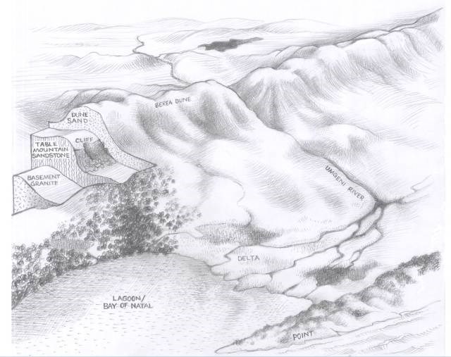
Oblique Section of the Berea Dune
The Berea Dune, of fine sand, blown inland from the shoreline, built up over many thousands of years to form the Berea Ridge of today, the foundation to the homes of may Durbanites since the 1850’s. These sands were originally white and calcareous and derived from earlier eroded Pliocene marine beds; a proportion of feldspar, and grains of silica and clay eroded from inland granite and Natal Group Sandstone, brought down by rivers like the Umgeni.
Many thousands of years of tropical weathering slowly converted a percentage of the feldspar to kaolin clay. The lime content in the sand (from the marine shell components) was leached-out, and iron-bearing minerals in the sands oxidised to be converted to red hematite and goethite, staining all the sand grains red, hence the Berea Red. Residents on the Berea today will be aware of the clay-like component to their garden soils when wet soil clogs the treads of their gardening shoes. The staining affect of the red soil on clothes will be all too evident to mothers of young children whose charges come in from the playground.
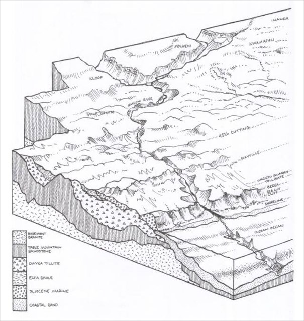
Some sections of the Berea Dune lie atop a bed of dark foundational Ecca Shale. Above the shale is a layer of lighter basal conglomerate sediment containing marine sand and many round sandstone clasts and pebbles. This the result of the shoreline having been situated nearby and the waves having pummeled and eroded platforms and cliffs into the beds of Natal Group Sandstone (Table Mountain Sandstone). Along these platforms the sea deposited conglomerate beds of sand, boulders and pebbles, eroded by the sea or brought down by rivers from inland. As the sea retreated, onshore winds blew fine marine sand and seashell fragments from the beaches inland where it accumulated along this conglomerate band to form the Berea Dune. Lower layers of this fine dune sand is visible as the white deposit. This sand has been leached by rain water. Above this layer is an accumulation of the typical and well-known red Berea dune sand.
Other sections of the Berea Dune lie atop beds of Dwyka Tillite. This can be observed at Umgeni Quarries, where the Umgeni River has cut a course through the Berea Dune and the Dwyka Tillite on its path to the sea.
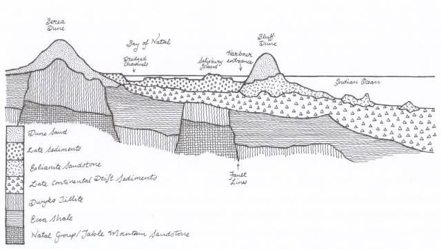
Cross Section of Durban from the Berea to the Bluff
Earthcache Logging Tasks
In order to claim a find on this Earthcache, please complete the following tasks and email the answers to me via my geocaching profile.
From your vantage point, look eastwards - can you imagine viewing just sea where the city, harbour and Bluff is?
Task 1: Looking towards the coast = observe the current shoreline and consider that the shore used to be at the base of the Berea - what (in your opinion) caused the shoreline to recede to the position where Umbilo and Umgeni roads are today? Use the text in the description and your observations to come to your conclusions.
Task 2 : What caused the deposition of sands to form the fossil dunes? In your opinion was wind or wave action the predominant force? What makes you come to this answer?
Task 3: Examine the soil at GZ - the sand is a different colour from what you would expect for beach sand. Why would you think this is?
Task 4: (Site verification question): On the steel door of the small brick shed at GZ a number has been painted in yellow. What is this number?
Task 5: (optional) - Please take a photo of you, your GPS and the view, or any combination thereof.
References
UKZN Geology - http://www.stec.ukzn.ac.za/geologyeducationmuseum/kzngeology/Cenozoic.aspx
Graham McCallum - https://grahamlesliemccallum.wordpress.com/2014/11/28/bay-of-natal-its-formation/
