Rub' al Khali - the Empty Quarter
Rub' al-Khali is the largest continuous sand desert in the world. The desert spreads over 1000 km from northeast to southwest and 500 km from northwest to southeast, covering an area of about 600.000 km2 mainly in the southern part of Saudi Arabia but also in Yemen, Oman and the United Arab Emirates. The desert is situated within a structural basin, a geological recess surrounded by wind-blocking obstructions that trap sand no matter how long the wind blows. The basin is tilted, with the thinnest sheet of fine, soft sand in the west where the elevation is highest (abt. 600 m), and a thick mantle of sand that supports dunes and salt flats in the lower-elevation east (around sea level).
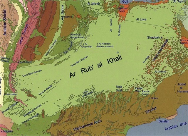
Geologic map of Rub’ al Khali (source: H. S. Edgell, Arabian Deserts – Nature, Origin and Evolution; Springer 2006)
The sources of sand for the sand dunes desert is still under discussion: The dunes are formed from quartz sand but almost all the surrounding outcrops consists of carbonate. It is assumed that over the past few million years in Quarternary, fluctuating water levels in the Persian Gulf could have periodically exposed a sandy sea floor ripe for plucking by prevailing winds onto the peninsula. The sand can acquire various colors through impurities or coatings. For instance, red sand is quartz with amounts of oxidized iron.
In Rub' al Khali , dune types range from solitary barchan dunes to extensive longitudinal dunes (300 km long) in the southwest and colossal dune mountains in the northeast. The dominating long, linear dunes form parallel to the prevailing winds. Active sand dunes are moving in general from northeast to southwest under the influence of the Shamal. Such sand dunes can reach heights up to 250 – 300 meters in southwest . However, there are also other types of dunes in Rub' al Khali, such as barchan dunes or star dunes. Of course, combinations of sand dune shapes can occur, so the patterns are often difficult to recognize. Complex dunes are combinations of two or more dune types and suggest that the intensity and direction of the wind has changed.

The region which you enter near GZ is named Ramlat Mitan, a south–eastern part of Rub' al Khali. First you have passed individual pyramidal dunes. Then the desert is dominated by linear belts of pyramidal dunes with individual but mostly joined dunes with heights up to 150 m and up to 2 km diameter. Arial views show very complex dune shapes which result from changing wind directions during the year. Typical for the southern part of the Arabian peninsula are winter winds directed from northeast to southwest but summer winds of opposite direction. This summer monsoon wind influences also the Ramlat Mitan region.
The basic typ of these barchanoid dune ridges is the barchan dune, a symmetric crescent-shaped dune. In their simplest form they are sickle shaped, with a steep concave slope on the down-wind side and gentler convex slope on the windward side. This type of dune possesses two horns or tips that face downwind. Often barchan dunes appear as larger, compound barchan dunes with a more complex structure. An interesting form which can be observed in this region is the whaleback barchan dune. The crescentic form is modified by winds from opposite directions. The back slopes are steeper than on conventional barchans, usually 10 – 20° and forms the typical shape of a whale's back.

Between the dunes ridges are interdune gravel and gypsum plains. In some places, they connect to form long accessible corridors into the desert. Their floor is usually a hard-packed combination of sand, mud and salt. It is easy to walk or drive 4x4 vehicles across the dry plains. However, after rains and flash-floods, the plains fill with shallow layers of water and cannot be crossed until they dry out to form a new crust. When the ground is partly dried, a salt crust forms over soft mud or hollow cavities, and a vehicle will become stuck after breaking through the crust.
Near GZ you are entering Rub' al Khali. Of course, you need a 4x4 vehicle and you should take extreme care. The desert can be dangerous. Don’t risk your life! The given coordinates are located at a 4x4 route often used by tourists. There are some green trees and it is a good place for a short stop.
To claim a find on this earthcache, please complete the tasks outlined below. Answers (in English or German) to the questions should be emailed to the cache owner and not mentioned in your online log. It is a good idea to take picture at GZ WITH installations to proof that you really have visited this place. But do not add the picture to your log. You can log this cache after you get the confirmation form the owner. Any logs not accompanied by an email will be deleted.
Questions:
1. The horns of a barchan dune are directed to the north. What is the direction of the wind? Please give the answer in this form: the wind blows from X to Y.
2. What are sabkhas?
3. What is the Arabic name of the Monsoon wind in the Dhofar region?
4. At GZ are some installations (Please do not add pictures of the installations to your log! ). Please describe what you see and what do you think what was their original purpose? Refer your answer to the geological situation. Maybe your guide can give you additional information.
sources:
H. S. Edgell, Arabian Deserts – Nature, Origin and Evolution; Springer 2006, ISBN 1-4020-3969-7
http://www.sgs.org.sa/English/Desert_Studies/Pages/default.aspx
http://space.gizmodo.com/the-empty-quarter-is-the-largest-sand-sea-on-the-planet-1697260622
Wikipedia