Trestle Rail Trail
This is geocache hunt will lead you along an old abandoned rail bed that has long since been converted to a bike and hike tail (not paved). As such the trail is linear; once you get to your destination, you'll have to turn around and go back the way you came.
This same stretch of trail, from Peterborough to Omemee, is now part of the infamous Trans-Canada Trail. As well, this section is part of a loop trail called The Central Ontario Loop Trail (COLT). COLT is a shared-use 450–km loop regional trail system passing through five counties in Central Ontario.
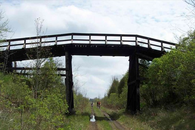
The highlight of this cache by far is the TRESTLE. Note that the folks helping out with the Trans Canada Trail have finally finished their work - the railing is complete and the trestle is now very bike friendly. Be sure to pack a camera and post lots of pics.
The parking coordinates (N44 18.558 W78 23.231) will lead you to Lily Lake Road where you can park your vehicle.
Although the method of transportation is up to you, bonus points will be awarded for those cachers who tackle the full "Omemee Ice Cream Run" (33km return). Your options...
- HIKE - very impressive if you go with this method
- BIKE - excellent choice
- X-Country Ski or Snowshoe - both excellent choices
- Drive/Hike Combo Thang - ok if it's raining otherwise you're missing out on all the great scenery not to mention the exercise ;-]
- Shuttle For those of you that have no interest in tackling the full 33km adventure (round trip), you could team up and park one car at the Omemee ice cream shop and then shuttle back to the posted coordinates.
|

|
|
|
Trestle View
|
View of a Trestle
|
- Waypoint 1: N44 18.458 W78 24.130
On the right side of the trail you will find a telephone pole. On the back is a number burned into the pole. Write down the 2-digit number beginning with "D-xx".
- Waypoint 2: N44 18.418 W78 24.754
Here you are looking for a 3 digit number written in white against a green background. Call this number "yyy".
- Waypoint 3: N44 18.381 W78 25.382
Another number burned into a telephone pole. This 2 digit number is in the form "Tzz". Write down the number "zz".
- Waypoint 4: N44 18.509 W78 27.968
Another 3 digit number written in white against a green background. Call this number "aaa".
- Waypoint 5: N44 18.372 W78 29.249
Here you will find a year (4 very large numbers). Write this number down "bbbb".
- Waypoint 6: Zee Cache.
Add up all 5 numbers collected at the waypoints above to get "TTTT" (xx + yyy + zz + aaa + bbbb). This number will have a digital root of 3 (see below for digital root definition). Place a decimal between the first and second digit of this number to get "T.TTT". Finally, add "T.TTT" to the minute portion of the following meaningless set of coordinates to get the final cache location.
- N44 15.327 and W78 26.728 (bogus coordinates, do not visit)
Please be VERY careful to leave the cache exactly as you found it AND feel free to add additional cover if necessary.
Finally, please do not include any spoilers in your logs. Unfortunately, logs with spoilers (such as a picture or description that provides extra clues) will have to be deleted immediately.
Ciao,
TRIPPER & fam.
NOTES:
- Winter friendly.
- Family and dog friendly... depending on which method of transportation you choose.
- Distance from posted coordinates to Omemee ice cream shop (N44 17.946 W78 33.568): 16.5km (round trip 33km)
- Click here to find out more about the Trans Canada Trail.
- Click here to find out more about the Central Ontario Loop Trail (COLT).
- Along this rail bed trail you may come across one or 2 local farmer's gates. Please do not open these gates. Carry your bike over. AND do not pay any attention to the signage; the rail bed IS owned by Canadian National and is now part of the Trans Canada Trail and the Central Ontario Loop Trail.
- What the hell is a digital root, you ask? The digital root is obtained by taking a number (say for example, 69), adding its digits (6+9=15), then adding the digits of numbers derived from it (1+5), etc., until the remaining number has only one digit (in this example, 6). The digit obtained (the 6) is called the digital root.
- If you haven't done so already, check out "Peterborough's First by Charles Baetsen" which is hidden close to the posted coordinates above.
Boooo!! No hints here.