LOCATION: Palisades Interstate Park, New Jersey Section,
Fort Lee, New Jersey (under the George Washington Bridge)
PARKING: The waymark will take you to the Parking
Area.
ALTERNATIVE PARKING: Ross Dock N 40 51.62' W 73 57.37' Note:
There is a $5.00 fee for parking May-Oct)
ACCESSING THE TRAIL: From the Parking Area, go around a
bend to the Henry Hudson Drive (which does have the occasional car
but is primarily used by bikers, joggers and pedestrians). If you
park at Ross Dock, walk back up the road you drive in on, toward
the George Washington Bridge.
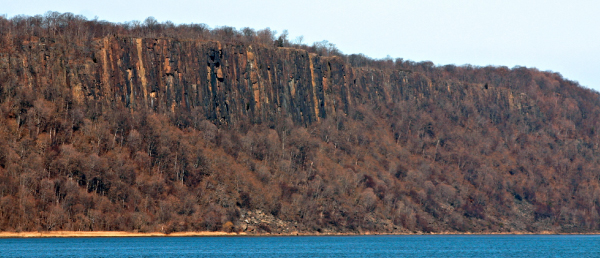
THE PALISADES SILL
The Palisades sill is an igneous intrusion that formed
approximately 200 million years ago in the Jurassic period. This
1000 foot thick intrusion “injected” itself between layers of
sedimentary rock of the Lockatong formation as the supercontinent
of Pangaea began to split apart (or "rift"), forming the North
American plate and the African plate.
The Palisades formed when rising magma (molten rock) from the
earth’s mantle pushed and stretched the overlying crust. As the
magma rose, the crust thinned and begun to crack and pull apart
from the tensional stress.
As the crust thinned and broke apart, cracks (or “faults”)
formed. In some places, the magma exploited these cracks and
continued to rise to the earth’s surface, forming new oceanic
crust. (You can see an example of this at the Watchung basalt
flows, west of the Palisades.)
In other places, the magma never reached the surface. Rather,
the magma plume rose from areas of high-density rock to areas of
lower density rock until it reached a location where the rock
density was equal to that of the magma. Then the plume stopped
rising, and instead flowed horizontally between existing layers of
rock, forming intrusive sheet structures called sills. This is how
the Palisades sill was formed.
If the rifting that led to the intrusion of the Palisades sill
took place 200 million years ago, and if rifting leads to the
formation of oceanic crust, then why isn’t the Palisades under
water today? The reason is that the Palisades sill is at a failed
rifting spot. While the continents were pulling apart at the
Palisades and Watchung, something happened to cause the rifting to
end at those locations and to begin at another location. The final
rifting took place approximately 100 miles to the east of where the
Palisades are today. As you would expect, the actual rift zone is
now under water. The rifting is taking place at the mid-ocean ridge
in the middle of the Atlantic Ocean.
The composition of the rock at the Palisades varies slightly
across the formation, but in general, the rock type is diabase,
also known as dolerite. Diabase is a basaltic rock (basaltic
meaning a dark, dense igneous rock) that is composed mainly of the
minerals feldspar (particularly plagioclase) and pyroxenes, along
with other mafic minerals (mafic minerals are a group of
dark-colored minerals, composed chiefly of magnesium and iron, that
occur in igneous rocks). The diabase that makes up the Palisades
sill has roughly the same composition as the basalt that forms the
bottom of the ocean and the mid-ocean ridges.
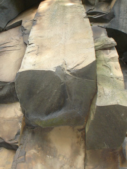
Xenolith N 40 51.055’ W 73 57.680’
A xenolith is foreign piece of rock embedded in an igneous rock.
This xenolith was ripped up from the surrounding Lockatong
formation as the magma intruded into the Lockatong. This is a
common process that occurs when a molten body of rock is injected
into existing rock. As you examine this site you will notice that
the edges of the xenolith seem disordered and mucky. This is due to
the movement of water that moved parallel to the bedding of the
xenolith. When water mixes with magma, it changes the chemical
composition of the magma and causes it to behave differently.
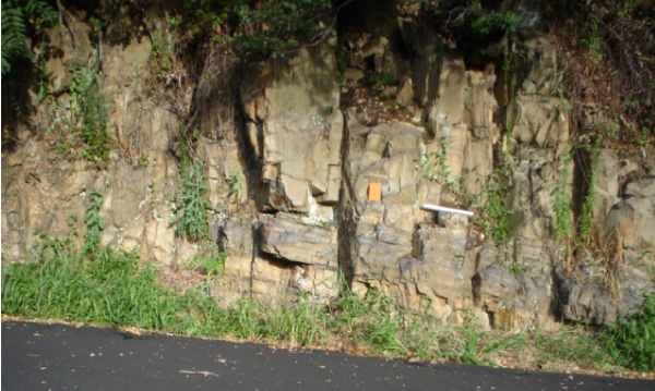
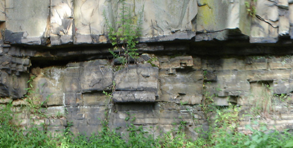
Columnar Joints and Lower Contact N 40 51.254’ W 73
57.575’
Here you will see two different features: (1) columnar joints,
and (2) the contact between the bottom of the Palisades sill and
older Lockatong sedimentary rocks.
Columnar joints
As you walk along the Palisades you may notice that sections of
rock look prismatic and are vertically stacked, like a group of
pencils standing on end. At this stop, look to the right and you
will see three of these structures hanging down from rocks. This is
called columnar jointing, and is common in basaltic rocks. Columnar
joints form when molten basalt cools and contracts as it hardens
into solid rock.
Lower contact
At the contact between the igneous rock and the older
sedimentary rock you will notice that the igneous rock is finer
grained and textured differently. This is because magma that cools
quickly forms smaller crystals than magma that cools slowly. The
temperature of the intruding magma was roughly 1400 - 1100 degrees
C and the surrounding country rock was about 25 degrees C. Thus, at
this contact the magma cooled very quickly, creating a very fine
grained crystalline rock. This is known as the chill zone.
Also, you will notice that below the contact, the sedimentary
rock looks baked. Once again this is because of the temperature
difference between the magma and the sedimentary rock. The heat
from the magma altered (or “metamorphosed”) the sedimentary rock,
transforming it into metamorphic rock called hornfels. Metamorphism
that occurs due to the heat of an igneous intrusion is known as
contact metamorphism.
To claim this cache: Answer at least one of the following
questions, and post your answer in your log. Tell us how many
people were in your group. (You don't have to wait for a
confirmation from us to claim the cache. We trust you!)
1. Describe the xenolith. Why is it there? 2. What is the
approximate height of the cliffs that make up the Palisades sill at
this location? (Use your GPS to determine the altitude at the
bottom and the top of the cliff.) To get to the top, use the stair
access to the right of the cliff at the circle by Ross Dock.)
REFERENCES
Husch, J.M., 1992. Geochemistry and petrogenesis of the Early
Jurassic diabase from the central Newark basin of New Jersey and
Pennsylvania: Geological Society of America Special Paper, v. 268,
p. 169-192.
Puffer, J.H., Husch, J.M., Benimoff, A.I., 1992. The Palisades
Sill and Watchung Basalt Flows, Northern New Jersey and
Southeastern New York: A Geological Summery and Field Guide: New
Jersey Geological Survey Open-File Report OFR 92-1.
Walker, K.R., 1969. The Palisades Sill, New Jersey: A
Reinvestigation: Geological Society of America Special Paper, v.
111, p. 1-166.
This Earthcache is brought to you by the
NEW JERSEY GEOLOGICAL SURVEY
an agency of the New Jersey Department of Environmental
Protection.


Visit us at www.njgeology.org