 Bringing the phrase "taking the high road" to geocaching, the object of this cache is to visit the highest point in a county, any county.
You'll have to do some research before you begin your adventure just to find the coordinates of the highest point within the county you're interested in. Several websites are available to help you with this research, including:
the County Highpointers Association,
the Highpointers Club, and
America's Roof. You may sometimes find the highpoint coordinates these sites provide are slightly off, but they'll get you close to the right spot; report the correct coordinates in your find report.
In the United States, "counties" are governmental districts that are larger than cities, but smaller than states. If you live outside the US, you'll have to use your own best judgement when deciding what's the local equivalent of a county. When in doubt, go for the highpoint of a state, province, territory, or even the highpoint of your entire country!
Once you've reached the highpoint, to score this cache you have to report:
- the name of the county,
- its state and country (if not the US),
- the latitude and longitude of the highpoint
- the highpoint's elevation (if known)
- a description of what you found there, any adventures you had on the way, etc.
- photos of the highpoint, the view from the highpoint, your dog chewing on your GPS at the highpoint, whatever. (Recommended, but optional since I realize that not everyone has a digital camera.)
Remember, your find report will allow the rest of us to vicariously share in your adventure so please make your report as detailed and interesting as possible.
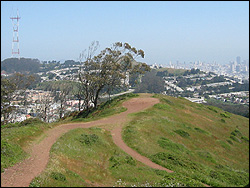
For example, the coordinates given for this cache are for the highpoint in the city and county of San Francisco, California: the top of Mt. Davidson. Since the early 1920s, there has been a hundred foot tall cross atop Mt. Davidson but, in order to avoid separation of church and state issues, the city auctioned it off several years ago to a private group. The peak itself, at an elevation 927 feet, is covered with eucalyptus trees and doesn't have much of a view. For this reason, I've posted a picture taken from a slightly lower elevation that has a view of Sutro Tower and the San Francisco financial district.
Please respect private property rights at all times. If a county highpoint is on private property, you must get permission from the landowner before proceeding. For example, if a fence prevents you from getting to the highpoint then you cannot score the cache–try another county or get someone to let you inside the fence.
Also, no old vacation reports please! You should only report highpoint visits made after you read this cache description. Thanks.
Other caches in this series:
'A' Is For Alum,
'B' Is For Beachhead,
'C' Is For Cave Dwellers,
'D' Is For Desert Phone Booth,
'E' Is For Expedition,
'F' Is For Faultline, and
'G' Is For Ghost Town.
Have fun and please share your adventures with us all!