Geocaching - The Official Global GPS Cache Hunt Site

You are not logged in. Log in.


GC25

Traditional CacheCamels Prairie Stash

A cache by Moun10Bike, Cindy, Laura and Jasmine     Hidden: 6/17/2000

Size: Size: Large (Large)     Difficulty: 2 out of 5     Terrain: 3 out of 5 (1 is easiest, 5 is hardest)


Related Web Page

You Are Not Logged InYou must be logged in with an account to view the detailed Location Information. It's free!

N/S ? ??.??? W/E ??? ??.??? 
In Idaho, United States

Print:
 5 Logs 10 Logs | 

Download: Read About Waypoint Downloads

| | |

Warning

Please note: To use the services of geocaching.com, you must agree to the terms and conditions in our disclaimer.

Idaho's first geocache
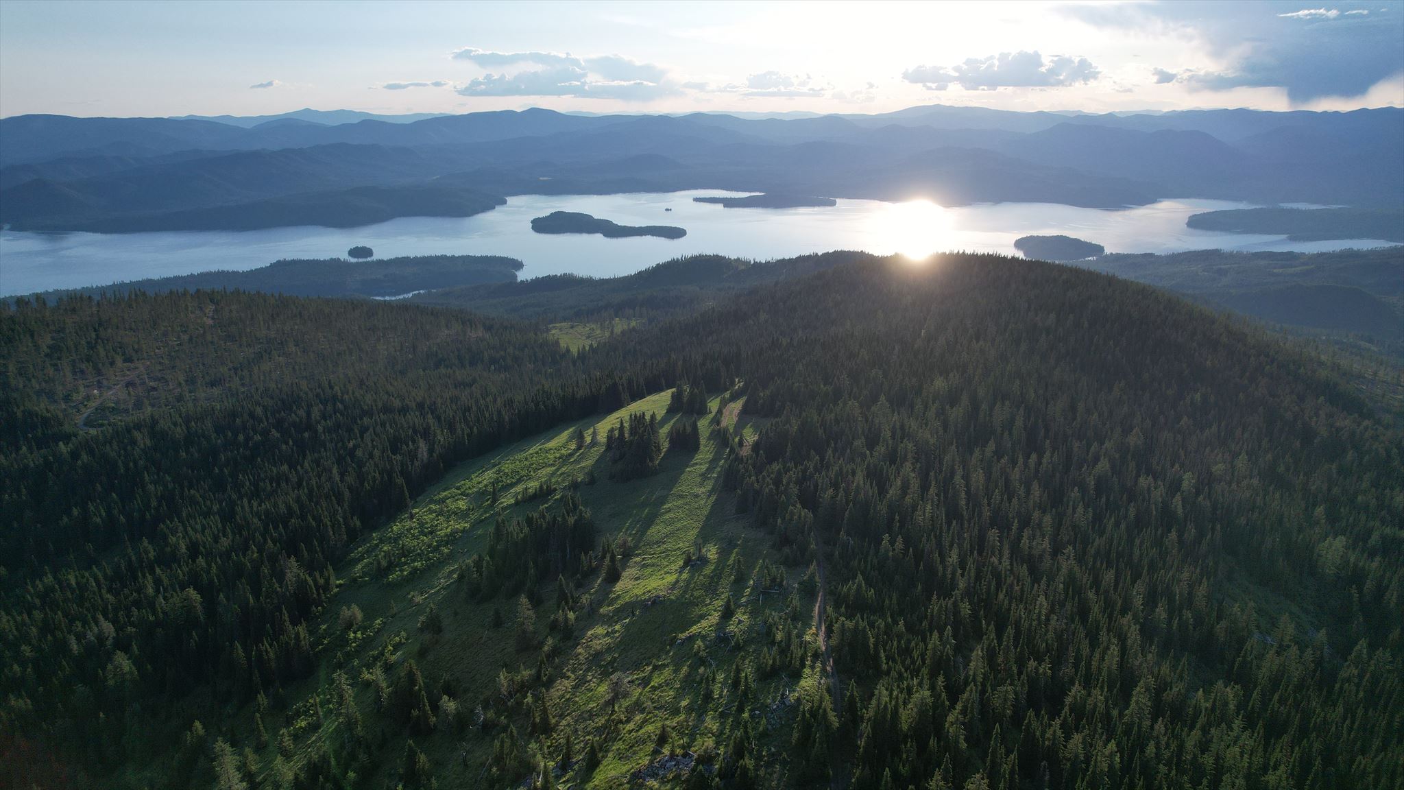
Looking toward Priest Lake from Camels Prairie

This stash is located near Priest Lake in the panhandle. It is a 5-gallon white bucket sunk into the ground with about 2 inches of the rim showing, and a lid labeled "GPS Stash." The stash site is located just off of a passable road near the summit, but those without a high-clearance/4x4 vehicle may want to park at the junction 1-1/4 miles below the stash site and walk the remaining distance. Overall, the stash is located about 10 miles off of the pavement.

Enjoy the hunt, and the spectacular views!

Idaho Geocachers


26 user(s) watching this cache.

Additional Hints (Decrypt)

Decryption Key

A|B|C|D|E|F|G|H|I|J|K|L|M
-------------------------
N|O|P|Q|R|S|T|U|V|W|X|Y|Z

(letter above equals below, and vice versa)

[The hint requires you to be viewing the posted spoiler photo] Gur pnpur vf ybpngrq gb gur evtug bs gur onfr bs gur fant frra ba gur yrsg fvqr bs gur cubgb. Lbh pna whfg oneryl znxr bhg n cvrpr bs gur juvgr yvq va gur cvpgher, oruvaq gur fznyy ybt ehaavat sebz gur onfr bs gur fant cnenyyry jvgu gur obggbz bs gur cubgb.(Decrypted Hints)

Find...

Camels Prairie

Viewed from below looking north.
Lower intersection (slight spoiler)

This is the road leading up to the summit of Camels Prairie at the point where it breaks off from the main road.
Looking south toward Sundance Mountain (SPOILER!)

The cache is just barely visible in this photo.
Looking north from a spot near the cache site

Priest Lake is visible below.

Logged Visits (91 total. Visit the Gallery (94 images))

Found it76     Didn't find it2     Write note13     

Warning. Spoilers may be included in the descriptions or links.
Cache find counts are based on the last time the page generated.

 September 16, 2009 by LBUK (602 found)
Found this cache while on an outing with friends from the Priest Lake Museum Association. Introduced a few of them to geocaching. This is a beautiful spot with 360 degree views of the mountains and Priest Lake. We walked the last 1.2 miles to the cache because the road was a little too steep and rough for some of the vehicles. Geocaching Kali, my 3-year old border collie, really liked the hike. Took nothing, left a key chain and Priest Lake Golf Course pencil. Lots of neat goodies in the cache! Log book was a little damp, but okay to write in with a pencil.

View This Log
 September 6, 2009 by dcrep (374 found)
My wife and I had a lot of fun doing this cache today. We were here this time last year, and I decided to do the Mt Roothaan cache instead of this one. On this trip our innkeeper recommeded Camels Prairie as a good huckleberry picking spot. We had rented a SUV on this trip so we'd be able to do all the mountain roads. That proved to be a good idea.

Found the cache at 11:30 am, in good condition. The weather was on and off rain, and at the elevation of the cache we were fogged in. It was very pretty around there. And as a bonus, we filled up a small bucket with huckleberries. Thanks for placing this cache, and it's an honor to find one with lots of history. TNLNSL.

View This Log

Photo lots of huckleberries along this road
Photo view along the road up

 August 21, 2009 by Plaidguy (4546 found)
Can't add much to what Prying Pandora said. All in all, a cool experience. Thanks, M10B!

View This Log
 August 21, 2009 by Prying Pandora (8237 found)
This turned out to be an epic way beyond what we had imagined. We thought we were well prepared, checked out the Garmin TOPO maps on our units, and planned our route with the roads we saw that led to the cache. How wrong we were. The side road we needed to access the cache had a big pile of logging debris bulldozed across it to prevent access, well over t.wo miles and a lot of elevation gain from the cache. Way too much to attempt hiking with evening approaching. We panned the maps around and began to lose hope - all this way and so close and today was our only opportunity to find it without having to sacrifice Mt. Roothaan. In desperation we found one of the few and far between places with cell reception and called Moun10Bike for some guidance. After a lot of dropped calls, we finally learned that Garmin's maps for this mountain are all wrong and that he had TOPO maps with corrected roads available on his personal website. Let that be a lesson to all that come after us - download his Priest Lake TOPO maps before embarking to find this cache. He gave us a rough idea of where the correct turnoff was, and soon we were driving up nice dirt roads through what Garmin thought was virgin timber. We got to the final fork in the road and decided we didn't have quite enough clearance to drive to the cache so we hoofed it up the rest of the way. About halfway up from there, there are tons of the BEST huckleberries for picking. We snacked and climbed, and WOW what a view! A little searching near GZ revealed the Ulmer-style hide. We signed the log, I left a coin and one of my pins. We lingered a little to admire the view then snacked on those primo huckleberries all the way back down to the car. Surely all the adventure would be over now. Spoke too soon. When we were about halfway down we saw a cow moose cross the road right in front of us, followed by her baby calf. The calf was curious about us and he lingered in the road to look his fill. I wasn't about to drive close to a baby moose to continue on our way and risk an angry defensive mom. So we waited and finally watched the moose calf follow his mother away. That was seriously cool - never been that close to one before. Thanks for the adventure and rescue Moun10Bike! You're one step closer to beatification in my book!

View This Log
Photo Plaidguy uncovers the stash
Photo Sunset at Priest Lake from the cache site
Photo Moose Calf

 August 8, 2009 by nelson crew (1420 found)
Well... here it is. A true caching benchmark, and a truly great experience.

The idea was to come up and pick some huckleberries. One of my attorneys has a cabin up here somewhere and knows every inch of these mountains like the back of his hand. He showed us where to go (stay on the 22) and made sure we were very clear on getting to above 4000 feet this time of year.

I made the rookie mistake of relying on the Nuvi instead of printing up some topo maps. Huge mistake on my part. Luckily I had been given such a thorough walk-through that I was able to back up the map view and get us where we needed by faking it.

On the way a couple of young guys in a dune buggy nearly creamed us. They were going so fast that when they saw us and slammed on the brakes they nearly took a header into the upside wall. Yikes.

Turns out that the spot I had coords for a) wasn't right on the road, as it appeared in Google Earth (but rather about 250 feet off), but also b) there weren't any huckleberries there. We did find some mountain raspberries, but there weren't that many of them, and the majority of them weren't looking too healthy.

Ok, scratch that. This trip was two-fold in purpose; find some huckleberries and find the oldest cache in Idaho. Since plan A was out, let's move on the plan B.

But how to get there? It's only a mile or so away... as the crow flies. These roads we're on now aren't even in the GPSr.

That's what I busted out the handheld GPS and found out that I had the roads in the palm of my hand the whole time.

Moun10bike, as part of his Northwest Trails project, not only had trails mapped, but had these mountain roads all mapped, too! Note to self - contribute more to the NW Trails project.

Excellent - let's make a right here and a left here and... there's the junction!

So I drive a 4x4. We were 1.25 miles from the cache with a serviceable road in a capable vehicle. But it was not to be. My mother had come along for the ride and she was VERY insistent that we were NOT going up that road. Ok, fine. I'm not getting this close to my goal without following through. I don't care if I have to hoof it the entire 1.25 miles uphill. Here's the keys, I'll be back.

The boy and I scoot up ahead with the furball, and what do you know - about a quarter mile in all of a sudden the road is just overrun with huckleberries EVERYWHERE. We could have easily spent a whole day here and barely made a dent.

Cache found - wow, awesome views. Today was overcast, so we didn't get the full effect, but still... I do believe I'll be bringing some others back here, so I'll see the whole thing yet.

Started back down the hill and found my mom had actually made it 2/3rds of the way up and was stopped with my wife at a huge huckleberry patch. Sweet! Goals A AND B fulfilled, plus the dog and I got an awesome hike in.

What a good day.

I'll post the better pictures, but with the haze and low ambient light most of them didn't turn out.

Took the jeep, left a couple of other trackables. Boo ya.

View This Log

Photo nice view of the haze
Photo purple mountains 2
Photo purple mountains
Photo huckleberries galore
Photo Holden on top of the world
Photo treehenge

There are more logs. View Them All on One Page

Current Time: 2/9/2010 9:57:10 PM (GMT-08:00) Pacific Time (US & Canada) (5:57 AM GMT)
Last Updated: 1/15/2010 8:32:16 AM (GMT-08:00) Pacific Time (US & Canada) (4:32 PM GMT)
Rendered: From Database
Coordinates are in the WGS84 datum


Geocaching, a Groundspeak Project.

Copyright © 2000-2010 Groundspeak, Inc. All Rights Reserved.
About Groundspeak | Contact Us
Designated trademarks and brands are the property of their respective owners.
Use of this Web site constitutes acceptance of the Groundspeak Terms of Use.
Read our Geocaching Logo Usage Guidelines.
Hotels | Altrec Gear | GPS Reviews