Gig
Harbor's First Geocache
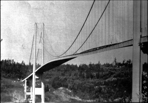 In August of 2001, with
a whopping find count of one, I got the urge to hide a
geocache of my own. TroubleChild and I used to hike down
under the Tacoma Narrows Bridge and walk along the beach,
skipping stones, playing with the crabs under the rocks, and
enjoying the incredible views of the bridge and Mt. Rainier in
the distance. This seemed to be the perfect place for a
geocache! We walked down the steep trail (there was even
a large piece of the old bridge buried in the trail) that used
to run directly under the bridge, strolled along the beach
until we found a spot, and hid the small ammo
can.
In August of 2001, with
a whopping find count of one, I got the urge to hide a
geocache of my own. TroubleChild and I used to hike down
under the Tacoma Narrows Bridge and walk along the beach,
skipping stones, playing with the crabs under the rocks, and
enjoying the incredible views of the bridge and Mt. Rainier in
the distance. This seemed to be the perfect place for a
geocache! We walked down the steep trail (there was even
a large piece of the old bridge buried in the trail) that used
to run directly under the bridge, strolled along the beach
until we found a spot, and hid the small ammo
can.
The crumbling bluffs have
changed the landscape continuously since we first hid the cache, at
times the beach was barely passable with the downed trees and
mudslides. This served to keep the cache interesting at
least. About a year later I replaced the cache container with
a larger one, updated the coordinates, and added a couple
hyperlinks to the tides tables and some nearby benchmarks.
Recently however, the construction of the new Narrows bridge has
closed the challenging trail and the cache was seldom seeing
visitors. The container began leaking and the contents had
degraded to simple junk. I gave consideration to archiving
this cache for many reasons. First, it's a simple cache, you
walk to the coordinates and find the box. Second, there are
now many other caches in Gig Harbor, this one was just not getting
the visits it used to. There also seems to be a preference
lately for less physically challenging caches that enable a cacher
to log dozens of caches in one day.
For many reasons I have
decided that the first geocache in Gig Harbor should remain.
The leaky container has been replaced and the cache filled with
great trade items, just as though it were a new cache. Check
the tide tables
before you visit, the cache should be easily accessible except
for when the tide is fully in. If you would like to read
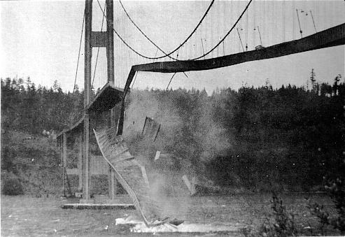
more about the history of the original Tacoma Narrows Bridge,
here are some results from Google.
There are also some
interesting old benchmarks along the beach as well, in fact, if you
drive over the bridge to get there, glance up at the red lights
atop the towers, they are benchmarks too!
East Tower, West Tower, and this Buoy are easy benchmarks.
An original light pole
from the first bridge was saved and placed in downtown Gig
Harbor. You can visit the Light Pole Park geocache and read more about
it there.
 Parking and a
trailhead are at N 47° 17.073 W
122° 33.119, and there is a gentle trail that leads
to the beach. The last few feet of the trail are
crumbling and can be difficult. If you visit the cache,
please keep us all updated on the condition of this portion of
the trail.
Parking and a
trailhead are at N 47° 17.073 W
122° 33.119, and there is a gentle trail that leads
to the beach. The last few feet of the trail are
crumbling and can be difficult. If you visit the cache,
please keep us all updated on the condition of this portion of
the trail.
.
Want even more of a
challenge? Do the cache at night! The trail and the
beach are safe for night navigation.
