
 No Trespassing signs have gone up since the EarthCache was listed. So you will only be able to view them from the road.
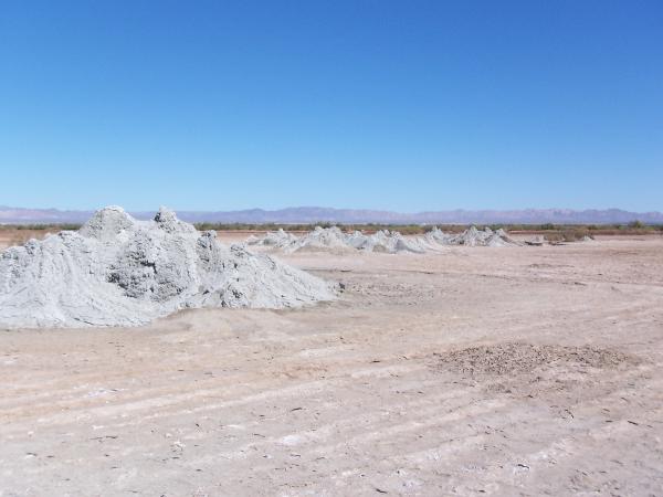
Salton Sea Mud Pots and Volcanoes These mud pots and volcanoes are located in an open field on the eastern side of the Salton Sea. The mud is just above ambient temperature and you can walk right up to the vents. However this is a natural system and temperatures will vary Use Caution.
 The mud pots and volcanoes are at the corner of two single-lane, smooth, hard dirt roads, Davis Rd and Schrimpf Rd. The easiest access is from the north or east. Be careful about the dirt road you choose as many driveways look like the main road. The field is covered in mud, so after rains expect to slog through the slippery stuff. There are no fences or warning signs at the site, but to be safe DO NOT ENTER ANY LOW LYING AREA AS IT MAY BE FILLED WITH CARBON DIOXIDE.
This location has a number of grey cones made of mud up to 6 feet high and some depressions filled with bubbling water and mud. These features are the result of the geothermal activity in the area. The entire valley you are in is on the boundary between the North American Plate to the east and the Pacific Plate to the west. The geothermal activity is the result of the spreading center beneath this area. For more info see the Salton Sea Geothermal Field.
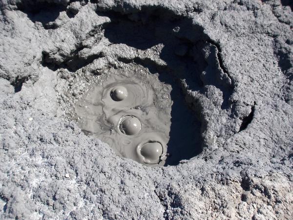 Even though these features are caused by geothermal activity beneath the area, the mud and gasses are usually just above ambient temperature. The bubbles coming out of the mud are not because they are boiling, but are gasses escaping up from deep in the earth. These gasses are generated by the hydrolysis.
Hydrolysis is the chemical decomposition of a compound into other compounds by reacting with water. In this case, ground water is reacting with limestone creating carbon dioxide. This reaction is likely sped up by the heat of the magma coming from the spreading center. There is so much carbon dioxide produced in the area that wells were drilled in the area to extract carbon dioxide wells and turn it into dry ice before refrigeration was invented.
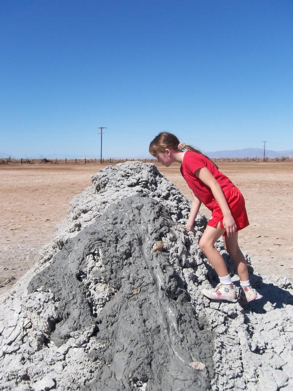 As you approach the mud volcanoes you can often hear the gurgling and sputtering of gas coming out of the mud. The level of the water varies by season and between adjacent pots. While we were there, two of the pots overflowed with mud and spit globs in the air.
Logging requirements:
Send me a note with :
- The text "GCZBZ3 Imperial Valley Mudpots" on the first line
- The number of people in your group.
- From the roadside, estimate the various heights of the volcanoes.
- How are the volcanoes clustered (high ones together, one large with a clump of smaller ones beside it, etc.)?
The above information was compiled from the following sources:
- A Guide to the Unexpected in San Diego and Beyond, Jerry Schad, http://www.sdreader.com/php/roamshow.php?id=20010301
- Mud volcano, Wikipedia, http://en.wikipedia.org/wiki/Mud_volcano
- Imperial Wildlife Area and the Wister Unit — A year-round display of wonder and wildlife opportunities, Patrick Moore, originally printed in Outdoor California Magazine, July – August 2001., http://www.dfg.ca.gov/lands/articles/imperial01.html
Resources I would like to have more scientific resources, but these are what I found. If anyone comes across a peer reviewed paper on these mud pots please let me know.