

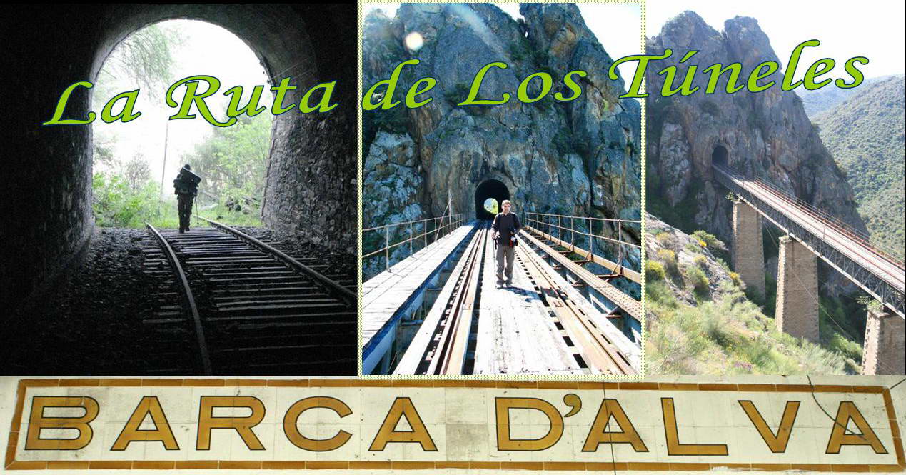
Esta cache foi colocada durante uma caminhada feita com o Mantunes nos dias 25 e 26 de Abril, na velha linha abandonada do Douro, entre La Fregeneda (Espanha), Barca d'Alva e Pocinho. 45 kms de linha, 22 túneis e 16 pontes. Dois dias, uma noite dormida na margem do Rio Douro. Duas multi caches colocadas, 9 espanhóis, milhares de morcegos, 2 águias, 2 bois, uma aranha e vários portugueses encontrados.
Uma grande caminhada e uma grande aventura cheia de momentos inesquecíveis.
Introduction:
P:Esta cache que cobre parte do trajecto por nós percorrido, leva-o a caminhar o troço de linha desactivado, entre Barca d'Alva e a estação de La Fregeneda. São 17 kms de percurso a subir para ganhar os cerca de 300m de desnível entre as duas estações.
Esta é uma cache que dedico aos GreenShades por terem sido eles que me deram a conhecer em 2005 este percurso e por nunca terem chegado a colocar esta cache, que seria certamente uma das próximas caso não tivessem deixado o Geocaching.
E:This cache which covers part of the hike we made, will take you to walk through the deactivated part of the railroad between Barca d'Alva and the station of La Fregeneda. It is a 17 kms of walk to climb to win the 300 meters around gap between the two stations.
I dedicate this cache to GreenShades for having been that they gave me to know that hink in 2005 and they never had come to put this cache, which would certainly be one of the next case had not left the Geocaching.
About the Douro Railway Line
A Linha Ferroviária do Douro - Porto S.Bento / Barca D'Alva - tem 202.200 Kms de extensão e desenvolve-se na sua maior parte junto às margens do rio Douro, ligando actualmente o Porto ao Pocinho - 174.200 km.
Foi uma notável obra de engenharia concluída em 1887 após doze anos de intensos trabalhos, vencendo-se inúmeros acidentes naturais, facto comprovado pelos 26 túneis e 30 pontes que nela existem.
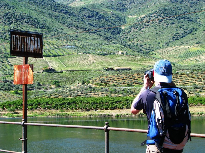
Esta viagem permite contemplar uma das mais belas regiões do país, o Alto Douro Vinhateiro. A emoção da viagem, com o Douro à vista, começa na Pala e vai aumentando a cada km que a locomotiva vai galgando.
A partir da Régua a paisagem altera-se. O rio Douro e as quintas com seus vinhedos em socalcos passam a ser companhia permanente do viajante revolvendo-lhe os sentidos.
 "Acordei envolto num largo e doce silêncio. Era uma estação sossegada, muito varrida, com rosinhas brancas trepando as paredes - e outras rosas em moitas, num jardim,onde um tanquezinho abafado de limos dormia sob duas mimosas em flor que rescendiam. [...] Sobre o telhado secavam abóboras. Por cima rebrilhava o profundo, rico e macio azul de que os meus olhos andavam aguados.
Sacudi violentamente Jacinto:
- Acorda, homem, que estás na tua terra!
Ele desembrolhou os pés do meu paletó, cofiou o bigode, e veio sem presa, à vidraça que eu abrira, conhecer a sua terra.
- Então é Portugal, hem!... Cheira bem.
- Está claro que cheira bem, animal!
A sineta tilintou languidamente. E o comboio deslizou com descanso, como se passeasse para seu regalo sobre as duas fitas de aço, assobiando e gozando a beleza da terra e do céu. [...]
Rolávamos na vertente de uma serra, sobre penhascos que desabavam até largos socalcos cultivados de vinhedo. Em baixo, numa esplanada, branquejava uma casa nobre, de opulento repouso, com a capelinha caiada entre um laranjal maduro. Pelo rio, onde a água turva e tarda nem se quebrava contra as rochas, descia, com vela cheia, um barco lento carregado de pipas. Para além, outros socalcos, de um verde pálido de reseda, com oliveiras apoucadas pela amplidão dos montes, subiam até outras penedias que se embebiam, todas brancas e assoalhadas, na fina abundância do azul. Jacinto acariciava os pêlos corredios do bigode:
- O Douro, hem?... é interessante, tem grandeza. Mas agora é que eu estou com uma fome, Zé Fernandes!
- Também eu!"
Entrada em Portugal do Sud Express por Barca d'Alva em A Cidade e as Serras de Eça de Queirós.***
Algumas páginas com informação sobre a Linha do Douro e o percurso La Fregeneda - Barca d'Alva.

The hike
P:
A caminhada pela linha férrea entre Barca D’Alva (Portugal) e localidade salmanticense de Fregeneda (Espanha) é um hino à contemplação da natureza. Os dezassete quilómetros da esquecida linha férrea são uma genial obra pública do final do século passado, um miradouro contínuo donde se desfruta uma das paisagens mais espectaculares e raras de toda a Península Ibérica. Este troço foi há pouco tempo decretado Património Nacional Espanhol, sendo a primeira obra deste género a merecer tal galardão.
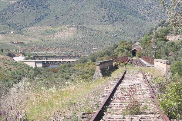
A ligação a Espanha por Barca d'Alva foi considerada de interesse económico fundamental em finais do século XIX, tendo a sua construção (inclusivamente do lado espanhol) sido financiada por um sindicato bancário portuense. Uma sucessão de 20 túneis e 13 pontes levava o comboio até La Fregeneda (a 17 Kms) de Barca d'Alva, donde seguia para Salamanca. Em 1988 interrompeu-se a circulação entre Pocinho e Barca d'Alva na sequência da decisão espanhola (1985) de abandonar esta ligação fronteiriça.
Por muito bom caminhante que seja, conte com, pelo menos seis horas, dados a dificuldade que vai encontrar. Para poder gozar a paisagem (com o rio Águeda do lado direito) sem abusar das suas forças, comece bem cedo para que na hora do calor já esteje a percorrer o último túnel (com cerca de 1,6km e que demora cerca de 25min a percorrer).
Equipe-se devidamente no que respeita ao calçado (há muita pedra solta do balastro da linha) e vestuário (é prudente levar calças grossas e mesmo luvas resistentes para passagens com mato). Lembre-se que não há onde abastecer água nem de comida ao longo do trajecto..
Ao entrar na linha procure adaptar a passada à irregularidade do piso (use as travessas). Aproveite as plataformas do lado esquerdo, geralmente com bom piso, mas seja prudente devido ao risco de queda.
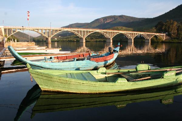
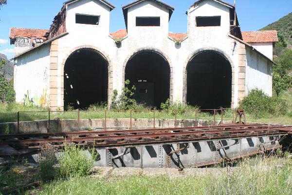
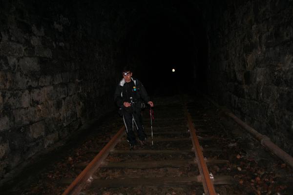
A caminhada deverá começar no largo principal (das Faias) em Barca d'Alva, onde deve estacionar e começar por visitar o cais fluvial e as pequenas lojas de comercio tradicional. Daí até à grande estação fronteiriça são cerca de 800m, e quando lá chegar não deixe de visitar os armazéns em madeira, a cocheira das locomotivas e a placa giratória de inversão de marcha funcional. Esta é (foi) considerada uma das mais importantes estações de Portugal, mas agora está em ruínas (é aqui que está a cache inicial). A destruição do património é chocante.
Por aqui entrou Jacinto, a caminho de Tormes, conforme Eça descreve em A Cidade e as Serras*** . Logo a seguir, a ponte internacional sobre o Águeda (185 m), que se diz ter um pilar oco para facilitar a demolição em caso de guerra. A partir daqui, está em território espanhol. Começam os túneis e as pontes (começa no nº20 e vai decrescendo)!
As pontes estão em mau estado, algumas devastadas por incêndios. Atravessá-las só para quem não tiver vertigens e só com tempo seco e sem vento. Nos 17Km temos de atravessar 13 pontes usando, em quase todas elas, um passadiço de ferro por vezes seccionado em espaços superiores a meio metro que só uma passada firme logra vencer. O perigo é latente.
Impõe-se a maior concentração. Abrigos de pastores de uma só porta, redondos e com tecto abobadado encontrá-mo-los ao longo da linha numa manifestação etnográfica interessante.
À passagem do um túnel nº 6 surge uma abertura a meio que nos permite observar a paisagem de um alcantilado sobranceiro ao rio. Impôs-se uma paragem para almoço nesta altura, pois o melhor vem a seguir..:)
A progressão pela linha faz-se bem pois que não há vegetação. O cheiro a rosmaninho e à flor da giesta é constante. O zimbro começa a invadir a linha. O património construído está em ruína, mas uma ruína ainda assim bela que evoca o romantismo de outros gloriosos tempos em que o comboio silvava naquelas serranias. Parar a meio das pontes (a mais espectacular é a ponte Pollo Valiente que apresenta curvatura) e olhar as profundezas até ao rio Águeda transmite-nos uma sensação de domínio sobre uma natureza agreste sobrevoada em círculos pelas águias e abutres-do-Egipto que abundam naquelas paragens. No céu vagueiam águias reais e enormes abutres leonados cujos ninhos se encontram nas vertentes das encostas. Vemos também algumas tímidas e delicadas cegonhas negras. Mais se parecendo com um farol, um longo vértice geodésico destaca-se num local que se designa por Peña del Sastre.O silêncio da paisagem só é cortado pelo restolho da caminhada pelo balastro da linha.
Depois de vencido o túnel que alberga uma grande colónia de morcegos (por favor não incomodar) surge a ponte Morgado, a última, deparamo-nos com um cenário fantástico de imensidão e horizonte natural com a ribeira de Morgaez do nosso lado direito. O rio Águeda desaparece. Por fim temos que atravessar o último túnel com mais de 1500m de extensão. Outros 19 já passaram, mas este é o mais espectacular! No fim está a estação de La Fregeneda.
E:
The walk on the railway line between Barca D'Alva (Portugal) and salmanticense town of Fregeneda (Spain) is an anthem to the contemplation of nature. The seventeen kilometres of railway line are forgotten a genial public work the end of the last century, a viewpoint where continuous enjoys one of the most spectacular landscapes and rare throughout the Iberian Peninsula. This section was recently decreed Spanish National Heritage and is the first work of its kind to earn this award.
The connection to Spain for Barca d'Alva was considered of vital economic interest at the end of the nineteenth century, and its construction (including the Spanish side) was financed by a bank syndicate port. A series of 20 tunnels and 13 bridges took the train to La Fregeneda (to 17 kms) from Barca d'Alva, which went to Salamanca. In 1988 the movement is interrupted between Pocinho and Barca d'Alva following the Spanish decision (1985) to abandon this connection border.
For hikers who is very good, content with at least six hours, given the difficulty that vai find. To be able to enjoy the scenery (with the right side of the river Águeda) without abusing their forces, get well soon so that at the time of the heat now will always go the last tunnel (nearly 2 km and that takes about 25min to go).
Team up properly in the case of footwear (a lot of loose stone ballast of the line) and clothing (it is prudent to take thick trousers and even resistant gloves for passages with weed). Remember that where there is no supply of water or food along the route ..
By entering the last line look to adapt to the irregularity of the floor (use the sleepers). Enjoy the platforms on the left, usually with good floor, but be cautious because of the risk of falling.
For Jacinto came here, the path of Tormes, as Eça describes in The City and the mountains ***. Soon after, the international bridge over the Águeda (185 m), which is said to have a hollow pillar to facilitate the demolition in case of war. From here, is in Spanish territory. Begin the tunnels and bridges (beginning in paragraph 20 and decreasing vai)!
The bridges are in bad condition, some ravaged by fire. Atravessá them only for those who do not have vertigo and only with dry weather and no wind. In 17Km have to cross 10 bridges using, in almost all of them, an iron passadiço sometimes cut by more than half a meter spaces that only last a firm achieves win. The danger is latent.
It is the largest concentration. Shelters of pastors at a door, round and with roof abobadado me find them along the line in a demonstration ethnographic interesting.
With the passage of a tunnel paragraph 6 is an opening in the middle that allows us to observe the scenery of a alcantilado overlooking the river. He lectured to a stop for lunch at this time, because the best is to follow ..:)
The progression is the line up well because there is no vegetation. The smell of rosemary and the flower of the broom is constant. The juniper begins to invade the line. The built heritage is in ruin, but a beautiful ruin that still evokes the romance of other glorious times when the train silvava those hills. Stop using the bridges (the most spectacular is the bridge that presents Pollo Valiente curvature) and look at the depths to the river Águeda send us a sense of nature on a rural area overflown in circles by eagles and vultures-of-Egypt that abound those stops. The silence of the landscape is only broken by restolho hike by the ballast of the line.
After won the tunnel which houses a large colony of bats (please do not disturb) is the bridge Morgado, the last, we have a multitude of fantastic scenery and natural horizon with the stream of Morgaez law on our side. The City Hall disappears. Finally we have to cross the tunnel last over 1500m in length. Other 19 have passed, but this is the most spectacular! At the end is the station of La Fregeneda.
P:
Há várias alternativas para fazer esta cache e apreciar as Arribas del Duero:
- Se quiser apreciar a Linha do Douro e fazer também a cache Na Linha do Douro, porque não fazê-lo de forma completa? Tome o comboio no Porto e viaje nele até ao Pocinho. Aí, inicie o percurso a pé até Barca d'Alva, pernoite numa das velhas estações abandonadas (aconselhamos Castelo Melhor por ser a que tem a melhor envolvente paisagística ou Almendra por estar mais ou menos a meio e por ter uma pequena praia fluvial) e continue no dia seguinte a caminhar até Barca d'Alva. Depois de descansar e se reabastecer pode iniciar o percurso, fazendo esta cache, e seguir até à estação abandonada de La Fregeneda. Nesta opção convém falar com o sr. Amadeu (trasporte de carro, ver contacto abaixo) para os irem buscar à estação abandonada de La Fregeneda no final do percurso ou arranjar transporte por sua conta para o regresso. Conte com 2 dias e 1 noite para este programa completo, mas verifique se é compatível com os horários dos combóios (se não quiser acampar pode optar por fazer 28km no primeiro dia e ir jantar e dormir na pensão em Barca d'Alva).
- Outra maneira de fazer estas duas caches é deixar o carro em Barca d'Alva e aí arranjar transporte para o Pocinho (além do transporte do sr. Amadeu também há camionete), fazer os 28km no primeiro dia até a Barca d'Alva, jantar e dormir aí, e no dia seguinte fazer os 17km até à estação abandonada de La Fregeneda. Quando chegar à estação pode solicitar o transporte do sr. Amadeu que o irá buscar de volta a Barca d'Alva. É melhor combinar previamente com ele. 2 dias e 1 noite para este programa completo.
- Outra opção mais rápida, é dirigir-se a Barca d'Alva, estacionar e iniciar a caminhada fazendo esta cache, e seguir até à estação abandonada de La Fregeneda. Nesta opção convém falar com o sr. Amadeu para os irem buscar à estação abandonada de La Fregeneda no final do percurso ou arranjar transporte por sua conta para o regresso (se forem com mais que uma viatura, deixem uma na Estação de La Fregeneda para vos trazer de volta a Barca d'Alva ou irem buscar os restantes carros). Conte com um dia bem preenchido, o melhor será dormir ou a noite antes ou a depois na Pensão Bago d'Ouro, no largo das Faias, junto ao cais fluvial em Barca d'Alva (dormida com pequeno almoço a rondar os 45€, mas se quiserem uma alternativa mais em conta contactem o sr Amadeu e digam que são geocachers ;)).
- Outra opção ainda, será a de percorrer o percurso até conseguir encontrar a cache final e voltar ao Barca d'Alva. Provavelmente, terá somado mais uma cache à sua conta pessoal mas não terá usufruído de todo o prazer que esta caminhada proporciona. Os últimos quilómetros até às estação de La Fregeneda valem bem o esforço. Conte também com um dia.
Alternativa para procurar a cache fazendo a caminhada a partir da estação de La Fregeneda: Em alternativa, e se quiser percorrer a linha ao contrário, descendo a partir da estação de La Fregeneda até Barca d'Alva, vá até N 40º 59.324 W 006º 50.234 e veja a data que está no poste. Anote-a. Para chegar à cache final subtraia à data encontrada 1388. Esse valor corresponde a ABC. Para obter DEF subtraia à data do poste as décimas (3 algarismos) da Latitude do 2º ponto físico, cujas coordenadas se encontram no ponto inicial da cache. Ao valor que deu subtraia 819. A cache final está em N 40º 57.ABC W 006º 51.DEF. Boa caçada!
Atenção: em qualquer das alternativas não há hipótese de levar qualquer veículo até perto da cache, apenas ao ponto inicial. A linha situa-se numa zona montanhosa e qualquer situação que ocorra só há dois caminhos possíveis: ou para a frente até La Fregeneda ou para trás até Barca d'Alva.
Informações adicionais: 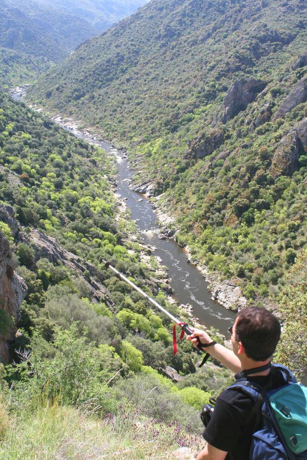
- Transporte em Barca d'Alva: Sr. Amadeu - 965 099 700. Alternativa: Taxi de Castelo Rodrigo: Lopes & Filhos - 271 312 112
- O sr. Amadeu é uma pessoa de idade e que gosta de ajudar. Não tem qualquer relação connosco. Ele já está habituado a receber os geocachers e faz muito gosto em ajudar com o transporte conforme a necessidade (Barca d'Alva-Pocinho, ou Barca d'Alva-estação de La Fregeneda, ou vice versa), por um preço em conta. Pode também ir buscar-vos ou levar-vos no vosso próprio carro, sem custos. Disponibiliza também alojamento a baixo custo para quem não tiver necessidades especiais de conforto e pequeno almoço (a opção é sempre a Pensão Bago d'Ouro). Contactem-no e combinem com ele o que precisarem.
- Horário dos comboios Porto - Régua - Pocinho.
- Restaurante e Pensão Bago d'Douro em Barca d'Alva: +351271355126
- Não há água no percurso. Abasteça-se no início. Leve comida para uma refeição ligeira.
- A rede de telemóvel é praticamente inexistente ao longo do percurso. Na parte final só consegue obter rede na estação de La Fregeneda através da rede espanhola. Não faça esta caminhada sozinho e se o decidir fazer avise alguém antes e vá fornecendo a sua posição durante a mesma.
E:
There are several alternatives to enjoy the hike through Rio Douro;
- Since the objective is to enjoy the Douro's Track and make the cache Na Linha do Douro, why not enjoy it in a complete way? Take the train in Porto and travel to Pocinho. Then, start walking to Barca d'Alva, spent the night in or near one of the old abandoned railway stations (we sugest Castelo Melhor that has the best Almendra surrounding landscape or to be more or less the environment and for having a small river beach) and continue the following day to walk to Barca d'Alva. After rest and refuel if you can start the hink, making this cache, and then abandoned until the station of La Fregeneda. In this option should speak with the taxi driver to go fetch the abandoned station of La Fregeneda the end of the route or arrange transport on their behalf for the return. Count on 2 days and 1 night to complete this program, but make sure it is compatible with the times of trains (if you do not want to go camping can choose to 28km on the first day and dinner and go to sleep in the pension Barca d'Alva).
- Another way to make these two caches is to leave the car in Barca d'Alva and then arrange transport for the Pocinho (also the addition of taxi van), make the 28km on the first day until the Barca d'Alva, dinner and sleep there, and the next day to make the 17km to the abandoned station of La Fregeneda. Arriving at the station may ask the taxi that will look back at Barca d'Alva. It is best combined with the previously mr. Amadeu. 2 days and 1 night to complete this program.
-
Another option faster, is to turn to Barca d'Alva, park and start making the trek this cache, and then abandoned until the station of La Fregeneda. In this option should speak with the taxi driver to go fetch the abandoned station of La Fregeneda the end of the route or arrange transport on their behalf for the return. Count on one day and completed, the better to sleep at night or before or after the Board Bago in Golden, in off the Faias, near the river pier in Barca d'Alva (is that the owner of the taxi).Another option faster, is to turn to Barca d'Alva, park and start making the trek this cache, and then abandoned until the station of La Fregeneda. In this option should speak with the taxi driver to go fetch the abandoned station of La Fregeneda the end of the route or arrange transport on their behalf for the return. Count on one day and completed, the better to sleep at night or before or after the Board Bago in Golden, in off the Faias, near the river pier in Barca d'Alva
-
Another option yet, will be to go the route to find the final cache and return to Barca d'Alva. Probably, you have added one more cache to its personal account but will not have enjoyed the pleasure of all that walking offers. The last kilometers to the station of La Fregeneda well worth the effort. Conte also with one day.
Alternative to look for the cache doing the walk from the station of La Fregeneda: Alternatively, if you want to start in final point of journey, in station of La Fregeneda, go to N 40º 59.324 W 006º 50.234, and see the date who is in post. Record it. To get to the end cache subtract at the date found 1388. This value corresponds to ABC. To find DEF, subtract the date of the poste tenths (3 numbers) of Latitude of the second fisical point of the cache (you found it in first point of the cache). Der to subtract the value found 819. The final cache is in N 40º 57.ABC W 006º 51.DEF. Good hunt!
Attention: Please note that in any of the alternatives there is no chance of taking any vehicle to near the cache, only the starting point. The line is located in a mountainous area and every situation that occurs there are only two possible paths: either forward to La Fregeneda or backward to Barca d'Alva.
Aditional information:
- Barca d'Alva taxi: Sr. Amadeu - +351 965 099 700. Taxi Castelo Rodrigo: Lopes & Filhos - 271 312 112
- Train timetable Porto - Régua - Pocinho.
- Restaurant and pension Bago d'Douro in Barca d'Alva: +351271355126
- There's no water in the trail. Supply yourself in the beginning. Take food for a snack.
- The phone network is virtually non-existent along the route. At the end can only get network in the station of La Fregeneda through the Spanish network. Do not make this hink alone and that the decision to let someone go before and supplying its position during the same.
The cache and the hunt
P: 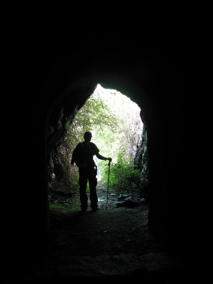
Material indispensável:
- Roupa resistente e confortável
- Calçado adequado (com sola semi-rígida e confortável)
- Protector solar
- Lanterna
- Máquina fotográfica
- Pilhas
- Mochila para grande caminhada
Esta cache é composta por três pontos e três containers. Uma micro no ponto inicial, uma small no ponto intermédio e a final é um tupperware de tamanho regular de tamanho +/- 10x15x10cm.
O conteudo inicial da cache além do Logbook, stashnote, lápis, afia e documentação é:
- Fita de pescoço
- Mola para papéis
- Boneco
- Porta chaves
Deixe-a exactamente como a encontrou, no mesmo local e bem escondida.
E: 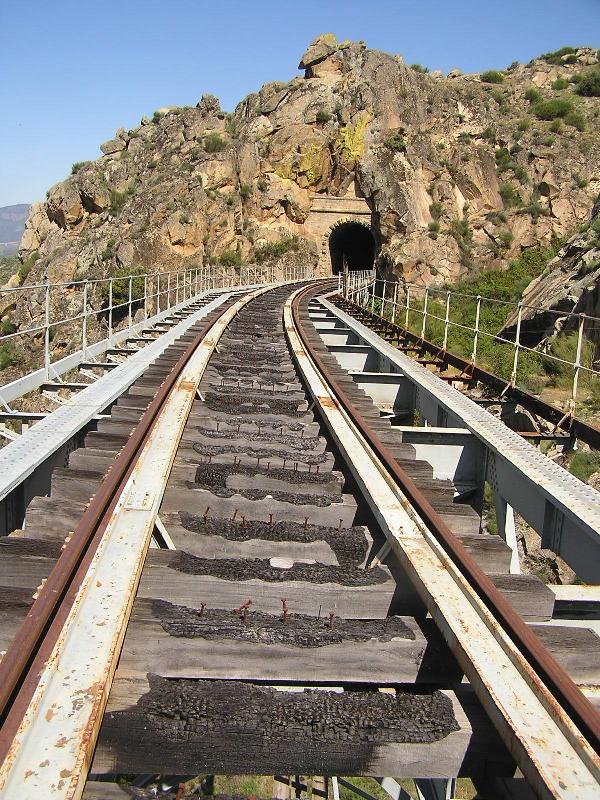
Material indispensable:
- Clothing resistant and comfortable
- Footwear appropriate (with sole semi-rigid and comfortable)
- Sunscreen product
- Flashlight
- Camera
- Batteries
- Large backpack to walk
This cache have three points and three containers. A starting point is a micro, a small in an intermediate point and the final is a tupperware of regular-size + / - 10x15x10cm.
The contents of the cache than the initial Logbook, stashnote, pencils, and documentation is:
- Suport keys of neck
- Spring for roles
- Boneco
- Keys support
Leave it exactly as found in the same place and well hidden..
Ah, e não se esqueça nunca/Oh, and never forget: Cache In Trash Out!
 ¤ menu > início :: La Ruta de Los Túneles - Barca d'Alva ¤ menu > início :: La Ruta de Los Túneles - Barca d'Alva |
translate: 
|
|
|