Portuges (Google Translate)
Nomenclatura
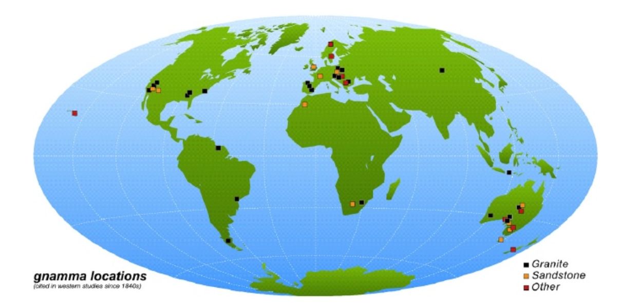
-'Gnamma 'É o termo amplamente usado para descrever uma depressão circular ovalar comumente contendo água sazonalmente. "Pits, tigelas 'são forma hemisférica, enquanto' panelas 'possuir fundos chãos de maior desenvolvimento laterais sobre a recessão vertical. 'Gnamma' são o resultado da resistência a longo prazo e são geralmente vistos em terra firme ou muito grandes blocos de rocha. Termos similares são “opferkessel” (alemão, aproximadamente "bacia sacrificial"), "poltrona ocos", intempéries panelas (ou poços) e panelas solução (ou boxes). Em Português e galego são chamados “pias”.
Origem
-Têm sido propostos dois tipos genéticos de Gnamma. Uma origem de subaéreo ou epigénica, em que a acumulação de água de superfície sobre uma concavidade leva à formação de uma cavidade por desgaste físico e / ou químico. Outros Gnamma têm uma gênese mais complexo relacionado com a concentração de tensões em determinados pontos do maciço granítico durante a colocação da intrusão e, portanto, podem ser considerados como recursos endógenos (Vidal-Romaní 1985)
-Há ampla evidência de que as bacias são devidas ao ataque de umidade, o que produz formas arredondadas de perfeição considerável através da concentração de intemperismo em projeções.
-"Pias" (Gnammas) são depressões formadas em rocha sólida (Twidale e Corbin, 1963). Morfologicamente eles variam em detalhes, mas a maioria é oval, elíptica ou circular no plano. Alguns, fortemente influenciada pela articulação, são angular na forma, e outros, resultantes da coalescência de dois ou mais indivíduos, são irregularmente lobulados no plano. Todas servem como armazenagem temporários de água. A água acumulada da chuva e do escoamento é perdida ou através da evaporação, ou a utilização pelos animais (incluindo os humanos), ou por bacias rock underground são depressões formadas em rocha sólida (Twidale e Corbin, 1963). Morfologicamente elas variam em detalhes, mas a maioria é oval, elíptica ou circular no plano. Alguns, fortemente influenciada pela articulação, são angular na forma, e outros, resultantes da coalescência de dois ou mais indivíduos, são irregularmente lobulado no plano. Todos são armazéns de água temporários. A água acumulada da chuva e do escoamento é dissipada ou através da evaporação, ou pela utilização por animais (incluindo os humanos), ou por infiltração no subsolo. Alternativamente, se a oferta excede a armazenagem e perdas, a água nas bacias burda, formando uma saída para que a depressão eventualmente torna-se parte de um sistema de drenagem integrada.
Evolução
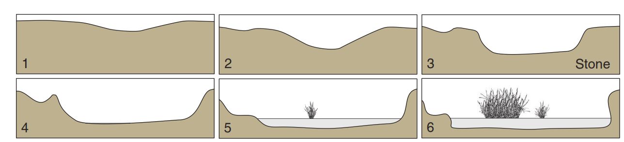
1- Pias menores e tigelas desenvolvem-se a partir de irregularidade da superfície e / ou fraquezas litológicas (Pe., juntas, xenólitos, mudança textural).
2- Pias ampliam-se e aumentam em profundidade, comumente sazonalmente enchendo-se com água.
3- A “pia” desenvolve paredes verticais, resultando em formas de marmita. Vertedouros são incipientes. A precipitação sazonal remove o lodo acumulando, areia e alguns seixos.
4- Aumento das taxas do crescimento dos laterais e as velocidades de aprofundamento diminuem. Ampliam-se lateralmente e os fundos aumentam para produzir panelas mais amplas. Subprodutos da erosão acumulam-se.
5- Taxa de crescimento das paredes diminui. Poços adjacentes e panelas podem se aglutinar em gnammas maiores. Vertedouros ampliam-se com canais marcados. Revestimentos Rocha pode evoluir para de cementação, que promove o desenvolvimento de lábios. A “Pia” começa a encher com subprodutos da erosão ou através de contribuições de lodo e areia.
6- Canais e vertedouros unem-se as gnammas adjacentes. Acumulação de sedimentos suporta o crescimento da planta (grama, musgo, carriço, … ) para colonizar a depressão.
Observam-se Gnammas em blocos de rocha em algumas áreas, sugerindo que as formas evolucionam rapidamente em termos geológicos - em questão de alguns milhares de anos.
Morphology
São reconhecidos vários tipos morfológicos:
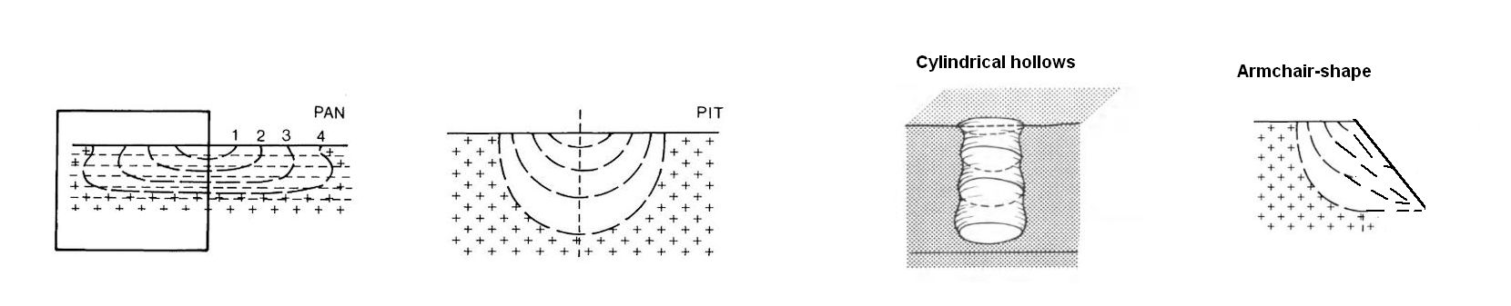
- “Pits” são hemisférica e desenvolvem-se em encostas suaves
- “Pan” são relativamente raso, são planas, e também são desenvolvidos em encostas suaves
- “Cavidades cilíndricas”, geralmente são circulares e retangulares em secção vertical, de modo que eles sejam apropriadamente referidos como de forma cilíndrica
- Depressões em "forma de silha" são assimétricas na seção normal, com os contornos, tendo altos respaldos do lado da curva ascendente, mas sendo abertos na descendente. Eles são típicas das encostas íngremes.
Para registrar este earthcache, envie-me um correio eletrónico com a resposta para as seguintes perguntas:
1) Segundo a classificação dada no listing ¿Qual é a morfologia da “Pia”? , calcula a sua profundidade. Veja só a de maior tamanho e mais perto do topo
2) Segundo o texto, ¿em que fase se atopa esta pia? (1,2,3,4,5 ou 6). ¿Por quê?
3) ¿Quantas “pias” pode ver no topo da rocha aprox.?
4) Adicione uma fotografia sua no local ou outra na seja possível ver um objeto ou seu nick em um papel
- Se acredita ter concluído com sucesso os objetivos desta Earthcache e já me enviou todos os requisitos conforme solicitado, por favor, sinta-se à vontade para a registar como encontrada. Posteriormente verificarei os requisitos enviados e, caso seja necessário, contacta-lo no sentido de efetuar as devidas correções ao seu registo.
-Todos os logs sem respostas, serão apagados sem aviso prévio.
English
Nomenclature
-‘Gnamma’ is the term now widely used to describe an ovalor circular depression commonly containing water seasonally.‘Pits, bowls’ are hemispherical in shape, whereas ‘pans’ possessflattened bottoms from increased lateral development over vertical recession. ‘Gnamma’ are the result of long-term weathering and are generally seen on bedrock or very large blocks of rock. Similar terms are opferkessel (German, roughly “sacrificial basin”), “armchair hollows”, weathering pans (or pits) and solution pans (or pits). In Spanish they are tinajita. In Portuguese and Galician are called pias.
Origin
-Two genetic types of gnammas have been proposed. One of subaerial or epigenic origin, in which the accumulation of surface water on a concavity leads to the formation of a hollow by physical and/or chemical weathering . Other gnammas have a more complex genesis related to the concentration of stresses in particular points of the granite massif during the emplacement of the intrusion and, therefore, can be considered as endogenous features (Vidal-Romaní 1985)
-There is ample evidence that basins are due to moisture attack, which produces rounded forms of considerable perfection through the concentration of weathering on projections.
-Rock basins are depressions formed in solid bedrock (Twidale and Corbin, 1963). Morpho-logically they vary in detail, but most are oval, elliptical or circular in plan. Some, strongly influenced by jointing, are angular in form, and others, resulting from the coalescence of two or more individuals, are irregularly lobate in plan. All are temporary water storages. Water accumulated from rainfall and runoff is lost either through evaporation, or use by animals (including humans), or by underground Rock basins are depressions formed in solid bedrock (Twidale and Corbin, 1963). Morpho-logically they vary in detail, but most are oval, elliptical or circular in plan. Some, strongly influenced by jointing, are angular in form, and others, resulting from the coalescence of two or more individuals, are irregularly lobate in plan. All are temporary water storages. Water accumulated from rainfall and runoff is lost either through evaporation, or use by animals (including humans), or by underground seepage. Alternatively, if supply exceeds storage and losses, the water in the basin overflows, cutting an outlet so that the depression eventually becomes part of an integrated drainage system.
Evolution
1- Minor depressions and bowls develop from surface irregularity and/or lithologic weaknesses (i.e., jointing,xenoliths, textural change).
2-Depressions enlarge and deepen, commonly seasonally filling with water.
3-Bowls develop vertical walls resulting in pan-forms. Spillways are incipient. Seasonal precipitation removes accumulating silt, sand, and some pebbles.
4-Lateral growth rate increases and deepening decreases.Bowls enlarge laterally and bottoms flatten to produce broader pans. Surface skins and coatings may develop to facilitate lipped and flask-like edges.Weathering byproducts accumulate.
5-Lateral growth rate decreases. Adjacent pits and pans may coalesce into larger gnammas. Spillways enlarge with defined channels. Rock coatings may develop into case-hardening that promotes the development of lips, visors, and flask-shaped profiles. Sediment infilling begins with weathering by-products (i.e., grus) or through aeolian contributions of silt and sand.
6-Channel and spillways link adjacent gnammas. Sediment accumulation supports plant growth (grass, moss, sedge, small plants) to colonize the depression. Once sediment and plant-filled, they act as sumps and/or as reservoirs for adjacent downslope gnammas.
-Rock basins have developed on scree blocks in some areas suggesting that the forms evolve quite rapidly in geological terms - in a matter of a few thousands of years.
Morphology
Several morphological types have been recognised :
- pits are hemispherical and developed on gentle slopes;
- pans are comparatively shallow, are flat floored, and are also developed on gentle slopes;
- cylindrical hollows vary in plan shape, though they are generally circular and are rectangular in vertical section so that they are appropriately referred to as being of cylindrical form;
- armchair-shaped hollows are asymmetrical in section normal to the contours, having high backwalls on the upslope side, but being open downslope. They are typical of the moderately steep (20 -30 ) slopes that lead down from the flattish crestal areas to the steep bounding slopes and the plains.
To log this earthcache, send me an email/message with the answer to the following questions:
1) Which is the rock basin (Gnamma) morphology accordingly the text classification?, calculates its depth. See just the biggest one, near top.
2) Which it is the gnamma (the biggest one) phase accordingly the text classification? (1,2,3,4,5 or 6). Why?
3) How many basins can you see at top´s rock ?
4) Add a photo of yourself at the place, or another in which you can see an object, or your nick on a piece of paper
-If you believe you have successfully completed this Earth Cache goals and has already sent to me all the requirements as requested, Please, feel free to log it as found. Later i will verify the requirements sent and, if necessary, contact you in order to make the necessary corrections to your log.
-Logs without answers, will be deleted without notice.
