In 1983, an enormous landslide dammed up the Spanish Fork River and
created Thistle Lake. The tiny Utah railroading town of Thistle
drowned. The massive earth movement severed railroad service
between Denver and Salt Lake City, flooded two major highways (U.S.
6 and U.S. 89) and resulted in Utah’s first Presidential disaster
declaration. Direct damage exceeded $200 million (in 1983 dollars),
making Thistle the most expensive landslide in U.S. history.
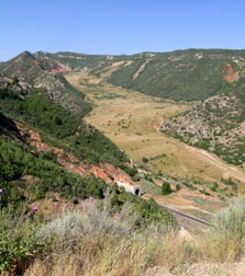
View from the Turnout on U.S.
6.
Objectives:
To witness for yourself the awesome
power of landslides and the effects they have on the landscape and
on the works of man.
To recognize the primary and contributing geological factors
that predispose a slope to become a landslide.
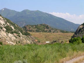
View from Thistle. Can you see the waterline
on the canyon wall to the left (160 feet maximum
depth)?
Directions: From I-15 near Spanish Fork proceed east on
U.S. 6. Stop at the turnout [N 40 00.264; W; 111 29.529] where you
will get a panoramic view of the slide. From there, proceed to the
U.S.89 cutoff and down into the valley where the town of Thistle
once stood [N 39 59.652; W 111 29.828]. Observe the place where the
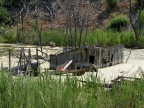
slide dammed up the Spanish Fork River. The ruins of the Little Red
Schoolhouse that was buried under Lake Thistle are just to the
southwest. There are more drowned buildings and trees a little
further along U.S.89 [N 39 59.344; W 111 29.946].
Supplies: Camera, binoculars, notebook. Web
access: You can get answers to the Study Questions from signage
at the listed coordinates, or from your own research on the www.
Wikipedia is always a good place to start but the best information
about Thistle is on the Utah Geological Survey website (see
below).
Educational Requirement: To get
credit for this EarthCache you must email us your answer to any one
of the Study Questions and let us know how many people were in your
party. Note: Apparently the descriptive sign has gone missing. You
can still meet the educational requirements by following the links
given below.
Study Questions:
- College-Bound AP: How fast did the Thistle landslide
move? Is it still “alive” or did the action end 20 years ago?
- Freshman: What were the geological factors that led to
the Thistle slide?
- Freshman: From a vantage point on U.S. 89, observe the
former high water level of Lake Thistle. How deep did the lake get?
How is it that this demarcation is still evident more than 20 years
later?
- Graduate: There is a saying that “Lightning never
strikes the same place twice”. Is this true for landslides? If not,
what is the evidence? How should this affect new construction on
sites previously afflicted by landslides?
- Graduate: What is the Uniformitarian hypothesis? Present
evidence for it’s relevance (e.g. a photograph from the Thistle
overlook that shows that what went on then is still going on
today).
- Ph.D.: Name some different kinds of landslides? Which of
these is the Thistle slide? A
technical, rigorous description of landslides.
LOL!
Links and Resources:
Still Swamped after 23
Years!