I was going to name this cache 'High Voltage Hum 2" in honor of an early OtisPug Cache we found on a nearby hill in 2002, but then I hit a snag.
Here's what happened: As some of you may know, I would just a soon hike two or three miles to find a benchmark, as opposed to finding a geocache under a lamppost skirt. In fact, I think I'm getting close to becoming a wannabe amateur surveyor. So, with some help from a slightly related business project, I squeezed a new, factory calibrated Timble GeoXH Handheld GPS into my budget. My goal was a geocache with about 30cm (about one foot) guaranteed accuracy, after post processing the data using the new NGS OPUS System.
Well, with all that neat new hardware, and the complete Orange County database of Triangulation Stations (so-called "benchmarks" on geocaching.com), I had a great time checking angles and distances to nearby "benchmarks".
Unfortunately, I forgot to record the coordinates where I left the cache! Oops! When I went back looking for it, do you think I could find it? Nope. So, here's the situation:
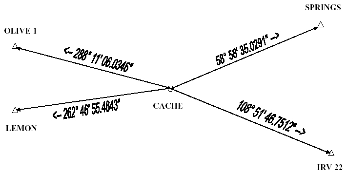
Here's the data in case the diagram isn't too readable (all are True Azimuth from the cache). Note that the format is in Degrees, Minutes, Seconds (DD MM SS.SSSS):
To SPRINGS: 58°58'35.0291"
To IRV 22: 108°51'46.7512"
To LEMON: 262°46'55.4643"
To OLIVE 1: 288°11'06.0346"
I've tried the obvious "draw some lines on a map" method, but that leaves a lot of area to search. You're welcome to try that. However, I know for sure that there is a mathematical solution to the problem, which should yield some nice accurate Lat/Long coordinates for your GPS. Keep in mind, you will still be dealing with at least the normal accuracy tolerance / precision of your GPS. I'm up to about 6 pages of paper & pencil, and about 25 rows & columns in Excel, and I think I need some help. Any mathematician geocachers out there?
If you should find the cache, it is a small 3" diameter X 5" high cammo'd cylinder, with the usual goodies inside. Good luck!
P.S. I'll be happy to confirm or deny (or estimate distance) for coords anyone comes up with (at least for the first few....). Please advise if they are from Map method or Math method.
Congrats to FTF'er "cache_in_pocket" for solving the math problem, and helping me find my cache! And, he did it using a different method than the "normal" math method. Honorable mention to "Mesa Mike" from Nuevo Mexico as the first out-of-towner benchmark hunter to solve it, using the "normal" math method.
Since it seems that getting benchmark data on geocaching.com is a thing of the past, here they are:
OLIVE 1: N33 49.957 W117 47.127;
SPRINGS: N33 50.233 W117 44.392;
LEMON: N33 49.421 W117 47.118;
IRV 22: N33 49.164 W117 44.292;
THESE ARE NOT CACHE LOCATIONS. They are data points (benchmarks) that you may / will need to find the actual cache.