Special Geology Of Flag Ponds
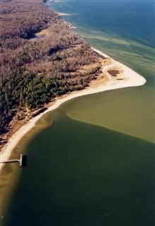 The beach at Flag Ponds
was formed gradually as sand from beach ridges and sand spits
accumulated over the last 2000 years. The resulting geologic
formation is called a cuspate foreland. The smaller,
northern portion of Flag Ponds is the oldest section with the
wider, southern portion building up over time.
The beach at Flag Ponds
was formed gradually as sand from beach ridges and sand spits
accumulated over the last 2000 years. The resulting geologic
formation is called a cuspate foreland. The smaller,
northern portion of Flag Ponds is the oldest section with the
wider, southern portion building up over time.
There are three conditions necessary to develop a cuspate foreland
such as Flag Ponds: sand, waves that move the sand in a predominate
direction, and a place along the shoreline to receive large
deposits of sand. These conditions exist in this location. Waves
along Calvert County are predominantly from the north, generating a
long shore current that moves to the south, carrying sand from the
northern part of Calvert County. Waves approaching the Flag Ponds
area are broken up by a flat platform of Miocene sediments,
preventing the longshore current from carrying the sand further
south and instead depositing it as a series of backward curving
spits and beach ridges.
What is "ecological succession"?
"Ecological succession" is the observed process of change in the
species of both plants and animals of an ecological community over
time. Within any community some species may become less abundant
and may even vanish from the ecosystem altogether. Similarly, over
some time interval, other species within the community may become
more abundant, or new species may even invade into the community
from adjacent ecosystems.
Why does "ecological succession" occur?
Ecological succession may also occur when the conditions of an
environment suddenly and drastically change. Forest fires, wind
storms, and human activities like agriculture all greatly alter the
conditions of an environment. These massive forces may also destroy
species and thus alter the dynamics of the ecological community
triggering a scramble for dominance among the species still
present.
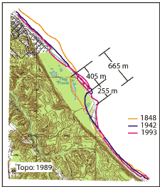 Here in Flag Ponds the
process of succession can be seen as you wander down the trail
leading to the beach itself. The slope that you walk now was once a
steep cliff, evidenced by the cliffs on both sides of the trail.
The Chesapeake Bay and the beach have been moving for decades. As
you make your way down to the beach, it is my hope that you will
learn about the process of succession and how new habitats are
being formed. It may be happening over decades of time, but the
world is changing. And as they say “Changes aren’t
permanent. But change is.”
Here in Flag Ponds the
process of succession can be seen as you wander down the trail
leading to the beach itself. The slope that you walk now was once a
steep cliff, evidenced by the cliffs on both sides of the trail.
The Chesapeake Bay and the beach have been moving for decades. As
you make your way down to the beach, it is my hope that you will
learn about the process of succession and how new habitats are
being formed. It may be happening over decades of time, but the
world is changing. And as they say “Changes aren’t
permanent. But change is.”
During your time here, you will need to note things from the
various signs and provide answers for the questions provided as the
alternate waypoints. While it is no longer required, it sure would
be nice if you posted a photo of yourself at the Duncan’s
Pond Observation Platform.
Bonus Question? #6
Post the coordinates of the extreme point of land south of the
“Pond in the Making” sign.
Information concerning Flag Ponds Nature Park:
Flag Ponds is named for the Blue Flag, a species of wild iris that
grows in profusion in the low marshy areas of the park in the late
spring or early summer. Located south of St. Leonard in Calvert
County, Flag Ponds Nature Park boasts hiking trails, a fishing
pier, a magnificent beach for swimming and fossil-hunting as well
as a nature center. Also on display is the “Buoy Hotel”
a fishermen’s shanty that allows visitors the chance to learn
about the Bay’s old-time fishing industry.
Hours of Operation are Seasonal:
From April to Memorial
Day
Weekends only, 9:00 a.m. - 6:00 p.m.
From Memorial Day to Labor Day
Monday - Friday, 9:00 a.m. - 6:00 p.m.
Weekends 9:00 a.m. - 8:00 p.m.
From Labor Day to last weekend in October
Weekends only, 9:00 a.m. - 6:00 p.m.
From Last weekend in October to first weekend in April
Weekends only, 9:00 a.m. - 5:00 p.m.
There is a small admission fee to use the park. And while trash
cans are available please exercise “Leave No Trace
Ethics” during your visit. Remember take only pictures and
leave only footprints.
Congrats to Mrs SeeKPeeKRs as the First to Answer all the
questions correctly.