Imperiosus Visum EarthCache
-
Difficulty:
-

-
Terrain:
-
Size:  (other)
Please note Use of geocaching.com services is subject to the terms and conditions
in our disclaimer.
Point Imperial offers magnificent views of both the Grand Canyon and the distant country and tells a geological tale of uplift and erosion that provides clues about how this Canyon was formed. To log this cache, visit the site, learn about its geology, and answer the logging questions below.
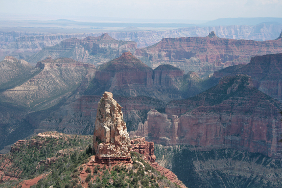
The Point is the highest spot on the North Rim, rising at 8,803 feet on the Kaibab Plateau, overlooking the Painted Desert and the eastern end of Grand Canyon. The area transforms as the narrow walls of Marble Canyon, visible only as a winding gash, open dramatically. Layers of red and black Precambrian rocks, not visible from Bright Angel Point, add contrast and color
Uplift
The Grand Canyon is one of the most spectacular geological landscapes in the world, cut by the Colorado River through arid-land erosion to form an immense canyon, one mile deep and 277 miles long. The Colorado was able to form the canyon here because of the uplift of the surrounding plateaus, which began around 75 million years ago. The rocks here are in the same formation as those found in Marble Platform, far below.
Geologists call the process of canyon formation "downcutting," which occurs as a river carves out a canyon or valley, cutting down into the earth and eroding away rock. In the upper reaches of the Canyon, this process is generally thought to have begun around 10-20 million years ago when the ancestral portion of the Colorado River formed. Around 5-6 million years ago, the Colorado and its tributaries began to cut through the lower portion forming the Canyon that we know today.
The section of the canyon viewed from the North Rim cuts through a bulge in the southwestern part of the Colorado Plateau called the Kaibab Uplift. The uplift created a steep gradient, which increased the river's speed and ability to cut through rocks. The arid climate also kept it from widening further, forming the deep canyon that we see today.
Plate tectonics created the plateau, but its action remains somewhat of a mystery. Geologists generally expect that uplift will crush and deform rocks, creating mountain landscapes like the Rockies. On the plateau, the rocks weren’t altered significantly; they were instead lifted high and flat. Some geologists believe that the uplift occurred because the angle of subduction from the Farallon Plate at the western edge of North America became much more shallow, pushing the effects inland. Others believe it occurred much later, after a period of significant erosion when the earth’s crust rebounded to form the plateau.
Erosion
 The formations of the Grand Canyon reveal a geological story of sedimentation, mountain building, and erosion. Nearly 40 layers of rock have been identified, taking us from the 2 billion year old Vishnu Schist at the bottom of the Inner Gorge to the 230 million year old Kaibab Limestone on the Rim.
As you look out at the Canyon, it is clear that you are far from the Colorado River. The North Rim is almost twice as far from the river as the South Rim, but is eroding away more rapidly. There are many factors causing this erosion: storms, freezing and thawing, heating and cooling. The North Rim has more rain and snow than the south rim. Almost all runoff flows toward the Grand Canyon. The result is deeper and longer tributary washes and canyons on the north side.
Logging Requirements
Answer the following questions based on what you have observed or learned. Send your answers through my geocaching profile before logging this earthcache as a “find.” I regret having to say that logs without answers will be deleted. Please email me through my profile rather than use the message center.
To log this earthcache, go to Point Imperial, read the information above and that provided at the site, and answer the following questions:
- When you are at Point Imperial, look to the Northeast to see the Marble Platform thousands of feet below. It is similar in one striking respect to the area where you are standing. What is this similarity and why is it important?
- One of the stunning features you see at Point Imperial is Mount Hayden. Based upon the diagram on this page, what kind of rock formation do you think comprises this Mount?
- How is the rock formation at the "base" of Mount Hayden different from the top? What do you think this says about the differences in these type of formations?
- Photo Requirement: This is a wonderful scenic location. Post a picture with your log showing the Mount. If you are not in the photo please include your gpsr, a personal item, or an informational sign in the picture (as permitted under the June 2019 guidelines).
Park Information
When visiting this earthcache, please stay on the designated trails and take care to leave nothing behind. This cache is easily accessible at the Point Imperial overlook, where parking is available, but be sure to bring water when the weather is hot.
The North Rim Visitor Center, as well as lodging and camping within the park, is open from mid-May through mid-October. Roads are closed during the winter due to snow. The National Park Service can assist you in planning your visit.
For More Information
The National Parks service provides an overview of the Canyon's Geological Formations as well as Geologic Views that will enrich your understanding and visit to the area. You can also learn more about the North Rim Geology from Anabelle Foos of the University of Akron.
Additional Hints
(Decrypt)