-
Difficulty:
-

-
Terrain:
-

Size:  (other)
Please note Use of geocaching.com services is subject to the terms and conditions
in our disclaimer.
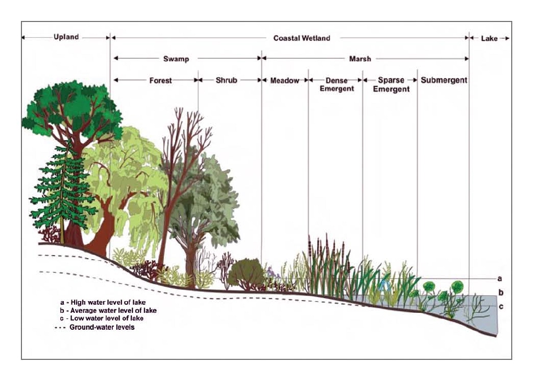 Wetland profile for Great Lakes
Marsh in shallow water on a lakeshore
Limestone:
Four hundred million years ago central North America was located near the equator. A shallow saltwater sea covered much of Wisconsin at that time. Corals, brachiopods, crinoids and other types of early marine life lived, thrived, and died here. Over the ages, their skeletal remains (calcium carbonate) built up, layer upon layer. With time, temperature and pressure, these layers were compressed and altered into limestone. As even more time passed, magnesium replaced portions of the calcium within the limestone, altering it into an even harder form of rock called Dolostone (Dolomitic Limestone).
Ice:
The advancing Wisconsin Glaciation Episode was forced to either side of the Dolostone ridge that ran the length of the Door Peninsula. This created individual finger like projections, called lobes. The Lake Michigan Lobe was forced east of the escarpment, carving out the basin that would become Lake Michigan. The Green Bay lobe gouged and carved a path in the soft Maquoketa Shale to the west of the Escarpment, forming what would become the bay of Green Bay. These lobes, as they advanced and retreated many times, carved, pushed and plowed the broken remnants of the underlying bedrock before (and with-in) them. Warmer climates eventually caused the glaciers to melt and retreat, leaving these broken remnants behind, creating ridges. Glacial melt-off and rising water levels was all that was needed for a bay to develop between these ridges. A marsh then formed in the shallows of this small bay. Basically, their are six different marsh types, all of which are described below. They are organized in a progression from driest to wettest.
Shallow Emergent Marsh:
These marsh types have mineral and/or shallow organic soils that are moist to saturated and only seasonally flooded. Abundant species found in these marshes include reed canary grass, bluejoint grass, rice cutgrass, bulrushes and Joe-pye weed.
Sedge Meadow Marsh:
These types of open wetlands are permanently saturated and only seasonally flooded. Soils are typically a shallow organic muck, although mineral soils could also be present. Beaked sedge, tussock sedge, bladder sedge and bristly sedge are dominant plant types in these meadows.
Cattail Marsh:
Common cattail and/or narrow-leaved cattail dominate these types of marshes. The muck and/or mineral soils found here are typically flooded with shallow standing water throughout the entire year.
Deep Broadleaf Marsh:
Water depth in this type of marsh is typically over one foot year round, although in dry summers, some marshes may have only saturated soils. These types of marshes contain organic type soils, which aid in the growth of broad-leaved arrowhead, pickerelweed and giant bur-reed.
Wild Rice Marsh:
This type of marsh is dominated by wild rice. It has an organic soil substrate that is flooded with one to two feet of water throughout the summer.
Deep Bulrush Marsh:
This type of marsh thrives in open water. Meaning that they are found along the shores of lakes and ponds. Water depths here range from one to six feet. Generally, soft-stem and hard-stem bulrushes dominate this type of marsh.
Importance:
Marshes are important for their water quality protection functions, including the trapping of sediments and transfer of nutrients, as well as stormwater and floodwater retention. They also provide some of the largest "natural" openings found in nature. They form a transition zone between aquatic and upland communities.
Animal Life:
Many species of birds including sandhill cranes, ring-necked pheasants, blackbirds, swamp sparrows, American and least bitterns, common snipes and sedge wrens live within the different marshes. An abundance of mammals such as beavers, muskrats, minks, foxes and many others consider the various marsh's home. Reptiles and amphibians that use these communities include common garter snakes, leopard frogs, green frogs and more.
This EarthCache is within Peninsula State Park so a Wisconsin State Park sticker will be required for entry.
Email your answers to the questions, to me, using the link in my profile only. If your answers are not recieved by me in an appropriate amount of time, your log will be deleted. Photos are accepted and appreciated as long as the answers to the questions are not revealed. You do not have to wait for confirmation from me before logging this cache as completed. Most of all……learn……and enjoy the view.
1. A marsh is an ever changing ecosystem. Snow cover, varying amounts of sun, changing water levels, pollution and many other factors can alter its appearance. Describe how the marsh appears on the day of your visit.
2. What type of marsh do you believe this to be?
The Geocache Notification Form has been submitted to of the Wisconsin DNR. Geocaches placed on Wisconsin Department of Natural Resource managed lands require permission by means of a notification form. Please print out a paper copy of the notification form, fill in all required information, then submit it to the land manager. The DNR Notification form and land manager information can be obtained at: www.wi-geocaching.com/hiding
Approved by Kelli Bruns
Superintendent
Peninsula State Park
Bureau of Parks and Recreation
Wisconsin Department of Natural Resources
Additional Hints
(No hints available.)