The Cap Sauer Esker EarthCache
-
Difficulty:
-

-
Terrain:
-

Size:  (other)
Please note Use of geocaching.com services is subject to the terms and conditions
in our disclaimer.
IMPORTANT NOTE: If you log a find on this EC without providing the appropriate answers, I will exercise the right to delete your log without explanation. Sorey, but this happens somewhat often. Please read the full listing & take appropriate steps to ensure your "Found It" is accepted. Thanks for visiting.
Cap Sauer Holdings is an Illinois State Nature Preserve that is part of the Cook County Forest Preserve District (CCFPD). Thanks to the CCFPD Regional Steward with whom permission was obtained in establishing this earth cache. Thanks also to the Palos Restoration Project volunteers for their hard work in maintaining Cap Sauer
Maybe all of those hills in this area look the same. But are they? Maybe not -- maybe you've seen an esker. Cap Sauer contains a great example of an esker, so let's explore it. The trailhead begins at the parking waypoint.
What Is an Esker?:
It is a winding ridge of gravel and sand which geologists believe mark the sites of sub-glacial streams and rivers. An esker can be 40-80 feet in height and its length may be anywhere from 1 to 20 miles. To describe this formation in layman’s terms, some say an esker resembles a standard railroad embankment.
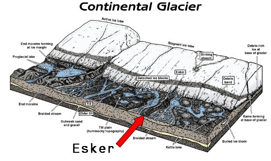
Most eskers are believed to form in ice-walled tunnels by streams which flowed within and under glaciers. After the retaining ice walls melt away, stream deposits remain as long winding ridges. Eskers may also form above glaciers by accumulation of sediment in supra-glacial (water flowing atop glacier) channels, in crevasses, in linear zones between stagnant blocks, or in narrow embayments (formation of bays) at glacier margins. Eskers form near the terminal zone of glaciers, where the ice is not moving as fast.
Eskers may exist as a single channel, or may be part of a branching system with tributary eskers. They are not often found as continuous ridges, but have gaps that separate the winding segments. The ridge crests of eskers are not usually level for very long, and are generally knobby. Eskers may be broad-crested or sharp-crested with steep sides. (The Cap Sauer esker seems to be a mix of these two elements).
The concentration of rock debris in the ice and the rate at which sediment is delivered to the tunnel by melting and from upstream transport determines the amount of sediment in an esker. The sediment generally consists of coarse-grained, water-laid sand and gravel, although gravelly loam may be found where the rock debris is rich in clay. This sediment is stratified and sorted, and usually consists of pebble/cobble-sized material with occasional boulders. Note that in Illinois, some eskers are made up of sandy, silty, gravelly deposits and contain mass-wasted diamicton material (meaning ‘poorly-sorted sediment’).
Getting to the listed coordinates and other notes:
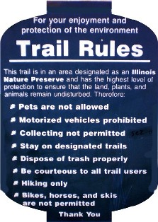
First, please note that this is a hiking-only trail; bikes, horses, motorized vehicles, and pets are not allowed. That being said, please DO stay on the trail at all times. Begin your hike southward and upward from the parking area.
Waypoint E1 is the site of a once-active quarry. Workers dug into the esker seeking its buried, gravelly treasure. There is no need to visit that waypoint, but you will pass near and have a generous view over the area.

Viewing west toward the esker's edge, from the bottom of the former quarry.
At Waypoint E2, Keep Right at the trail fork. Also, begin measuring your track from here to the EC's listed coords.
From this point onward, you are walking atop the esker.
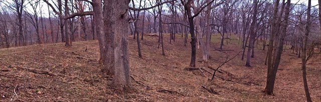
The Esker -- March 2016
Notice how this isn’t ‘just another hill’ in the forest. Pay attention to the esker’s form and the lay of the lands beyond it.
Make sure to stop at Waypoint E3 and move on. If you're enjoying the hike, continue on the trail past the listed coords toward Waypoint E4. That is a very scenic & peaceful area called “Visitation Prairie”. Sorry, no extra earth cache points are awarded for this, but the hike & the area itself are the rewards.
TO LOG THIS EARTH CACHE
Please complete the following tasks and
send your results through my Geocaching profile:
1. Waypoint E2: You’ve recorded your track from here to the EC's listed coordinates. What was the length of your trek on this portion of the esker?
- 1a. Note: If you hiked out to Visitation Prairie, you may send the length of that trek as an answer, but it is not required.
2. Waypoint E3: Estimate the height of the esker
3. At the listed coordinates, post a picture of your GPS device by the granite boulder (It is optional to include yourself in the pic).
4. Based on what you’ve read and what you see on the trail, what factors influenced the shape and size of the esker in its present condition?
Sources:
Illinois State Geological Survey (including top-most graphic)
Illinois D N R
MSN Encarta
Wikipedia
| With Mother Nature's help, I have earned GSA's highest level: |
 |
Additional Hints
(No hints available.)