 LCC 50th - Grant Wood Trail__
 ___
___
This
is the August, 2008 featured cache for the Linn County
Conservation's 50th Anniversary activities!
In 2008, the Linn County Conservation Board will celebrate 50
years of service to Linn County residents.
A yearlong celebration is planned to highlight all the outdoor
recreation opportunities available right here in Linn County.
In celebration of Linn County Conservation's 50th Anniversary there
will be 50 GeoCaches placed within various parks and recreation
areas in the next year.
This Cache will reveal a "clue" that will enable you to be
eligible for a special prize drawing at the end of the season
(December 2008)!
There is one featured cache each month. This IS the
Featured GeoCache for August 2008
Check the lid of this featured cache for a two digit number between
1 and 50.
Record this number as you will need it to find the Final Bonus
Cache of the Year.
(When you have all twelve numbers associated with the 12 featured
caches, you will be able to solve the puzzle and find the final
prize cache).
Additional information can be obtained from the Linn County Parks Website and
the Iowa
Geocachers Website.
You will be looking for an Ammo-Can
Other GeoCache's on Grant Wood
Trail
CLEARED FOR TAKEOFF
Trunk Road
Timber's Trail Treasures
MILWAUKEE ROAD CACH
Science Safari
Rockeller
AB-n-AP-n-Baby Too!
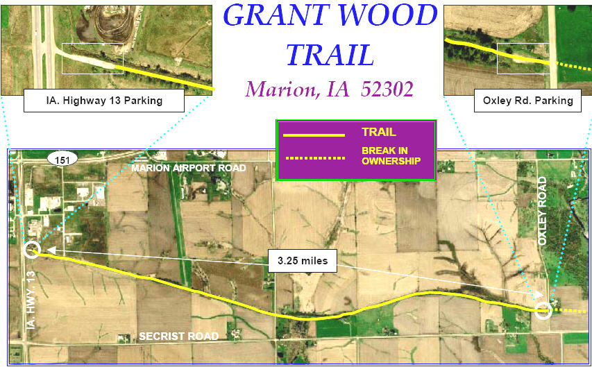
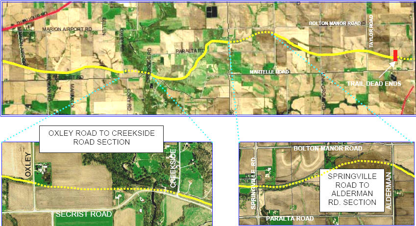
Grant Wood Trail
The Grant Wood Trail became part of the Linn County Conservation
park system in November 2005 when it was gifted to Linn County by
the Linn County Trails Association.
An abandoned railroad line, this trail is approximately 10 miles
long in total length and encompasses approximately 100 acres.
The trail stretches from Hwy. 13 on the east side of Marion, to
near Martelle.
Within Linn County, the trail consists of three separate sections
and therefore not a contiguous trail experience. (The 3.25 miles
from Hwy. 13 east to Oxley Road is the longest portion, and has
parking available on either end) See maps below for additional
information on the location of trail accesses.
Short-term future plans for this trail include new rock surfacing
on the above mentioned portion, and a tunnel under Highway 13 to
connect the trail with the city of Marion trail system and the
trails in Squaw Creek County Park. (NOTE: Federal grant monies
have been secured to complete both of these projects in the near
future)
This trail is part of our South Cedar District park management work
unit - headqartered out of Squaw Creek County Park.
__
___
Winter / Snow Rating:
Difficulty:  Terrain:
(1 is easiest, 5 is
hardest)
Terrain:
(1 is easiest, 5 is
hardest)