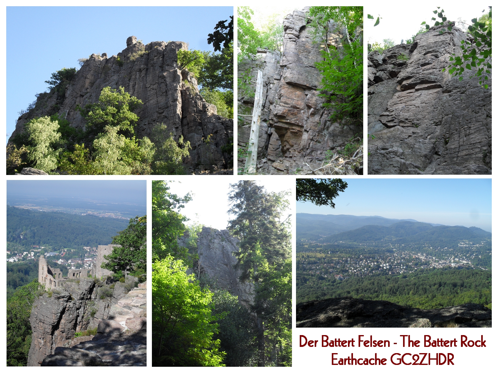
Am Westrand des Nordschwarzwalds, nördlich von der Stadt Baden-Baden erhebt sich der 568m hohe Battert.
An seinem westlichen Hang steht die Ruine Schloss Hohenbaden, auch altes Schloss genannt, das um 1100 erbaut wurde und 1599 durch einen Brand zerstört wurde. Es war der Herrschaftssitz der Markgrafen von Baden.
An der Südseite befinden sich die Battert Felsen, die als das bedeutendste Klettergebiet im Schwarzwald gelten. Hier können ganzjährig unterschiedlichste Routen in den Schwierigkeitsgraden III. – IX. in den bis zu 60m hohen Felswänden erklettert werden.
Geologie:
Vor etwa 260 bis 270 Millionen Jahren ist das rotbraune Sediemtgestein (Schichtgestein), aus dem der Battertfelsen besteht, entstanden. Dieses Gestein nennt man Oberrotliegendes oder auch Porphyrkonglomerat. Vor der Entstehung dieses Gesteins, waren die Vogesen in Frankreich und der Schwarzwald noch ein gemeinsames Gebirge. Durch eine Einsenkung, dieses Gebirges, kam es zu starker vulkanischer Tätigkeit. Dabei flossen quarz- und feldspathaltige Gesteine aus dem Erdinneren an die Oberfläche. Schichtfluten führten dazu, dass diese Gesteine (Quarzporphyr) zu eckigen und gerundeten Bestandteile in flachen Schuttfächer abgelagert wurden. Daher stammen die Körnigkeit und die horizontale Struktur der Felsen. Heiße Wasser, die durch den Fels aufstiegen, lösten diese Quarze und mit der daraus entstandenen Kieselsäure, wurde der gesamte Stein durchtränkt. Dadurch erhielt der Felsen seine Härte und wurde widerstandsfähig gegen Verwitterung.
Als der Oberrheingarben entstand, ist der Battertblock sehr hoch herausgehoben worden. Durch parallele Großklüfte wurde der Felsen in NW und SO Richtung zerschert. Die Erosion modellierte aus dem Battertmassiv, zahlreiche Schluchten und die, bis zu 60m hohen, mauerartigen Wände. Am Fuß der Felsen, sind Block- und Schutthalden entstanden.
Hinweis:
Ihr befindet Euch in einem Naturschutzgebiet. Verlasst bitte keine Wege und nehmt Eure Hunde an die Leine. Für den EarthCache ist es nicht notwendig zu klettern. Wer dies aber gerne am Battert Felsen tun möchte und die Ausrüstung und natürlich auch die entsprechende Erfahrung hat, darf dies auf seine eigene Verantwortung natürlich gerne tun. Informationen zu den Kletterrouten am Battert findet Ihrauf den Internetseiten des Deutschen Alpenvereins, unter der Rubrik "Felsinfo"
Zu den EarthCache-Aufgaben:
Begebt Euch auf den Battert Rundweg. Hier findet Ihr Informationstafeln (siehe Wegpunkte), auf denen Ihr die Antworten zu den Fragen erhaltet.
Frage 1: Der Battert Felsen besteht aus einem äußerst widerstandsfähigen Gestein.
Wie wirkte die Kieselsäure nach dem Auskühlen und Kristallisieren auf Gneis, Granit und Sandstein?
Frage 2: Vor wie viel Millionen Jahren ist der Battert Felsen entstanden?
Frage 3: Am Fuße der Felsen, sind durch Erosion große Blockhalden entstanden.
Welche neuen Pflanzenarten finden ihren Platz in den Blockhalden?
Frage 4: Da Ihr Euch in einem Naturschutzgebiet befindet, sind hier auch viele Pflanzen und Tierarten zu finden.
Welches Vogelpaar brütet wieder im Battert, welches 1960 in Mittel und Nord-Europa fast ausgerottet war?
Sendet Eure Antworten mit Eurem Nickname in der Betreffzeile an battert_earthcache@t-online.de .
Nach dem versenden der E-Mail dürft Ihr den EarthCache Online loggen. Ich melde mich dann per Mail bei Euch zurück.
Wer möchte kann an den Listingkoordinaten ein Bild von sich und seinem GPS und im Hintergrund die Bergwachthütte machen und in den Log Eintrag mit einstellen.
Wer T5 erfahren ist, darf natürlich auch ein Bild von sich in der Wand in seinem Log mit einstellen. Ein Bild ist keine Bedingung!
-----------------------------------------------------------------------------
English:
On the western edge of the northern Black Forest, north of the city of Baden-Baden rises the `Battert`- 568m high.
On its western slope you`ll find the ruined castle of Hohenbaden, also called `the old castle`, which was built at about 1100 and was destroyed by fire in 1599. The seat of power of the Margrave of Baden was based there.
On the south side there are the Battert rocks, which are considered as the most important climbing area in the Black Forest. Here, all over the year, routes on a wide scale of difficulties from level III to IX. may be climbed up to 60m high in the cliffs.
Geology:
About 260 to 270 million years ago the sedimentary rocks, the Battert rock consists of, were formed. These rocks are called Oberrot Prone or Porphyry Conglomerate.
Prior to the formation of this rock, the Vosges mountains in France and the Black Forest were still a common mountain. By a depression of this mountain there was strong volcanic activity. The result was that quartz and feldspar rocks flew out from the interior of the Earth to the surface.
Layer flows led to the fact that these rocks (quartz porphyry) were deposited into angular and rounded elements in shallow alluvial fans. This explains the graininess and the horizontal structure of the rocks. Hot water rose up through the rock, dissolved these crystals and the hereby resulting silica, and so the entire stone was soaked of it. This was why the rocks got their hardness and durability and became resistant to weather.
When the Upper Rhine rift valley develloped, the Battertblock has been lifted very high. The rock was split up into NW and SE direction by parallel large fissures. The erosion shaped the Battert massiv into numerous canyons and the up to 60m high, wall-like, walls. At the foot of the cliffs many large fields of boulders have been formed.
Note:
Always remember - you are in a conservation area. Please do not leave trails and put your dog on a lead. It is not necessary to climb for this EarthCache. But who of you would like to do this at the Battert rock and possesses the required equipment and also has got the appropriate experience, may do so on his own responsibility, of course.
To the tasks:
Start your way to the trail “Battert-Rundweg”. Here you`ll find information boards (look at waypoints) on which you will get the answers to the questions.
Question 1: The Battert rock consists of a highly resistant rock.
How was the effect of the silica - after cooling and crystallization - on gneiss, granite and sandstone?
Question 2: How many million of Years that the rock of Battert is formed?
Question 3: At the foot of the rocks there are large fields of boulders caused by erosion.
What new plants find their place in these fields?
Question 4: As you are in a conservation area, there also many plant and animal species can be found.
Which pair of birds breed again in Battert, which were nearly wiped out in 1960 in Central and Northern Europe?
Send your answers with your nickname in the subject line to : battert_earthcache@t-online.de
After sending this e-mail you`ll be able to get a log entry to this EarthCache. I'll sign up back to you by e-mail.
Anyone who wants - can make a photo of himself, his GPS and the mountain rescue hut in the background at all the listing coordinates - and add it to the log entry. Who's already got T5-experience may also take a photo of him in the rockface and add it to his log, as well. The Photo is volunteer.
--------------------------------------------------------
Danke an bobbele2 für die englische Übersetzung.