2009
2021
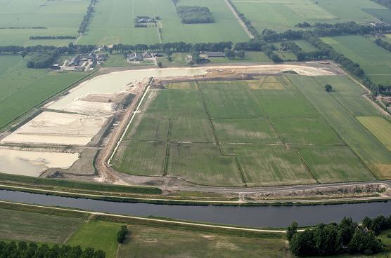
Dekzand is a few meters thick layer of sand in the subsurface of northwestern Europe during the Weichsel Glacial-the wind is deposited on older layers, an Aeolian process. Dekzand differs from other sand because it is deposited in a given period and in a certain way.
During the Early-Glacial vegetation was still such that the spray was essentially local in nature. During Pleniglaciaal, the coldest part of the Weichselian, the vegetation was almost gone and it could be deposited over large areas sprays, which because they almost completely cover the older sediments dekzanden mentioned. This is the Older dekzand that is layered horizontally and also where clay is found, called the Brabants clay. It will probably be fine sediment particles in the polar summer were carried and deposited by rivers.
In this period the North Sea was dry, and formed large parts of the Netherlands, Belgium, Germany and a kind of tundra or polar desert with shallow riverbeds. Dekzand once thought that it came from the dry North Sea. In mineralogical studies showed that the composition of the dekzand similar to the locally occurring formations.
During the Late Glacial by the growing vegetation dispersal lokaler again, what is called the Young dekzand. This is younger dekzand Mature dekzand that local and back again was blown off. The increased vegetation was dekzand blew up in a number of places held and called dekzandruggen arose. Rivierduinen of dekzand Donken be called.
Many old settlements arose on the higher and thus dry dekzandruggen. A familiar example is the esdorp, usually not a stream, but in a dry place at some distance it is located.
Tasks for logging this Earthcache
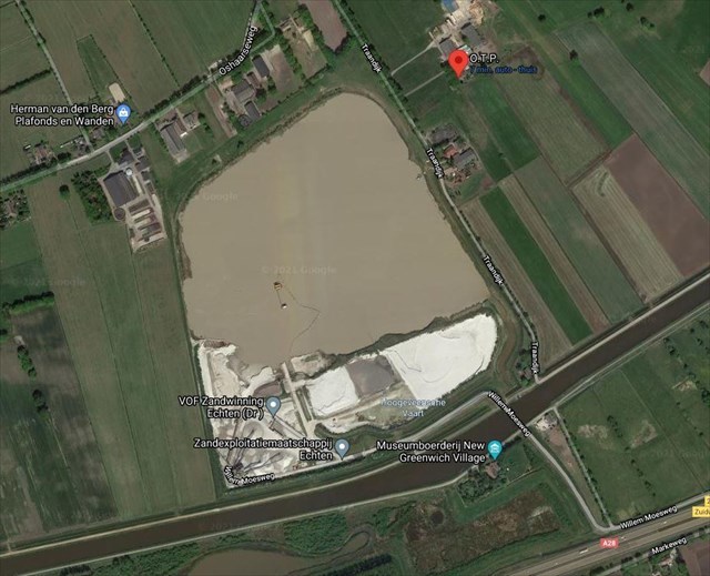
-Read the sign at N52 41.186 E6 22.616 and tell me what kind of sand (2 types) is found here.
-Read the sign at N52 41.158 E6 22.343 and tell me what you need to enter this area.
-Take a picture at N52 41.189 E6 22.588 with the mining area in back of you.
ATTENTION 1. Picture is not longer optional but required!!! Log without picture will be deleted sooner or later!!
ATTENTION 2. No cars allowed on the bridge. Only bikes and hikers!! So park your car nearby and walk!
And before anyone wants to complain about the photo: Due to the mass dissemination of EC solutions on the Internet, GSA and Groundspeak have released the EC owners since 10 June 2019, asking for a photo as proof of the visit. Please send us the two answers by our profile and upload the photo with your log. After the reply you are allowed to log immediately. If something is wrong, we will contact you. Logs without answers and without a photo are deleted without comment.
 Cache in, trash out! Neem altijd een plastic zak mee om zwerfvuil onderweg op te ruimen.