Phase 8: Fall of Fort Washington and the Loss of New York
The Revolutionary War in New York in 1776
Battle of Fort Washington
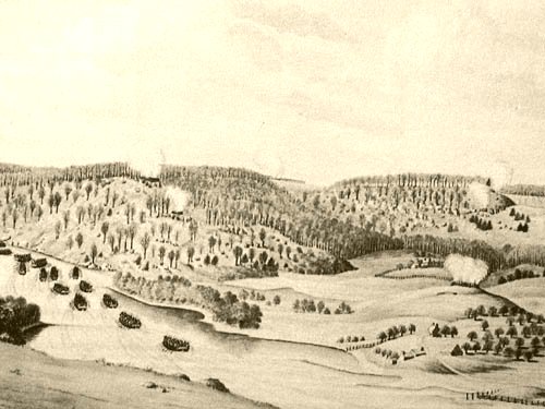
British attacking across the Harlem River. The Post Road today's Broadway splits Mount Washington (Washington Heights) on the right and Laurel Hill (High Bridge Park) on the left.
* * * * *
And the balls whistled deadly,
And in streams flashing redly
Blazed the fires;
As the roar
On the shore,
Swept the strong battle-breakers o'er the green-sodded acres
Of the plain;
And louder, louder, louder cracked the black gunpowder,
Cracking amain!
...second stanza of The Old Continentals by Guy Humphrey McMaster, 1848.
* * * * *
Phase 8 covers the Fall of Fort Washington and the final British expulsion of the American army from New York.
For weeks prior to the attack, British General Howe and his troops continued their dogged pursuit of Washington in numerous sites in Westchester county and the Bronx (See Phase 7). Although Washington was successful in some skirmishes, the British held sway so he and his generals decided for the army’s best interest to retire all American forces to New Jersey. He left a small force to defend Fort Washington and its northern redoubt (later called Fort Tryon) under Colonel Magaw. The commander-in-chief would have retired those forces as well, had not some of his generals urged the necessity of holding it, for the defense of the river. Only Fort Washington and Harlem Heights remained to be captured for the British to possess all of Manhattan and begin to dominate the entire length of the Hudson River.
We will approach its capture from the British perspective, much as we did the Battle of Brooklyn. Again, this will give you a fuller sense of the dimensions of the battlefield. We will visit High Bridge Park against the Harlem River which was the eastern edge of the battlefield. Other Hessian and British forces were to attack from the south below Ft. Washington and from the north from Kingsbridge in the Bronx into Fort Tryon. On the Hudson river, the British frigate Pearl bombarded the area from the west to divert attention from the land attacks in the north, east and south.
About the 1776 cache series:This series of caches take you through the political intrigues and armed battles in the city of New York during the Revolutionary War in 1776. Each cache Phase consists of a tour of the local area’s Revolutionary sites. You will gather clues that will provide the coordinates for the cache container for that Phase. Containers will vary from ammo cans, plastic containers and magnetic micros limited by the locale – woods, parks and urban street. The larger containers will have memorabilia such as replicas of revolutionary coins, paper money, musket balls, Declaration of Independence on parchment, etc. as well as more traditional cache treasure. Please take one memento only and leave the rest for other cachers. Leave something if you take something but don't stuff the smaller containers.
Click on the bookmark on the upper right side for a list of all 1776 cache phases. Each stands on it’s own. You do not have to follow any particular order although doing so gives a better prospective of the action. Cachers logging finds in all 8 phases will have their names added to the Cacher's Honor Roll in the Phase 8 cache web page. Campaign maps in the photo section provide orientation for each Phase and for the whole City. However, these are not needed to do the cache.
The caches follow much of this companion tour guide and book. For those traveling on foot, it provides public transportation methods for getting around. However, they are not required to find the cache.THE BATTLE FOR NEW YORK: The City at the Heart of the American Revolution by Barnet Schecter.
Start your Phase 8 tour at Dyckman House. Phase 8 campaign route is about a three mile drive and a walk to where the cache container is hidden in Ft. Tryon Park.
A. Dyckman House N40 52.027 W73 55.384
On the way to the eastern edge of the battlefield, the next stop, you’ll first visit Dyckman House. Open 11am-4pm Wed-Sat and Noon-4pm Sunday. Closed Monday and Tuesday but clue available at all times. Hession huts are very interesting 40 52.053 73 55.371. This authentic farmhouse was built in 1784, but it still holds great interest for the study of the Revolution. The Relic Room contains artifacts gathered from the battlefield of Fort Washington: bullets, cannon balls, explosive shells, guns, bayonets, a uniform, and even a tattered American flag. The reconstructed Hessian log hut in the small park next to the house would have been part of a larger encampment, one of many the soldiers lived in during the seven-year occupation of the island.
Dyckman House quiz- What is the middle word at the top of the small sign on the fence at the entrance?
1. British
2. Washington
3. Farmhouse
ENTER A answer (1, 2 or 3) = ________
B. McNally Plaza N40 50.889 W73 55.790
Sits on top of Laurel Hill 165 feet above the Harlem River above High Bridge Park where the eastern edge of the battle started. See picture above. While British cannons fired from the Bronx, Cornwallis and the Scottish Highlanders boated across the river and attacked Laurel Hill brushing the Americans aside at this point and another one further north. Fort Washington was a half-mile to the west. Step over to the park fence on your left and look down. The views of the slopes below you and the vistas of the Harlem River will give you a sense of the steep terrain the British ascended during the attack.
McNally Plaza quiz–Who is the last person listed in the column on the right?
1. Quincy S. Mills
2. Irving M. Wolk
3. James H. Mallon
ENTER B answer (1, 2 or 3) = ________
Simultaneously, south of Fort Washington, the Americans under Cadwalader were being chased to the fort by the British under Stirling, battling all the way. North of Fort Washington in the redoubt later to be called Fort Tryon, Colonel Moses Rawlings fended off the two columns of Hessians and Waldeckers under Knyphausen attacking from the north and where the fiercest fighting of the day took place. The redoubt was gallantly defended for some time, and many Hessians were slain. Rawlings was finally forced to yield, and retreated to Fort Washington, under cover of its guns, when Knyphausen planted the Hessian flag upon Fort Tryon. The British were closing the noose.
C. Colonel Magaw plaque N40 51.048 W73 56.247
You’re on Colonel Robert Magaw Place, two blocks from the Fort, named after the commander of Fort Washington whom the plaque honors.
Colonel Magaw plaque quiz- A small cross is welded atop one of the fence pickets beneath the plaque. Counting from the brick wall, which picket is it?
1. 4th
2. 5th
3. 6th
ENTER C answer (1, 2 or 3) = ________
D. Bennett Park marker N40 51.163 W73 56.263
You’re joined with other soldiers at the edge of the fort facing the British onslaught. The defense was gallant; but pike, ball, and bayonet, used by five thousand men, overpowered the weakened patriots, and by noon they were nearly all gathered within the ramparts of the fort.
Bennett Park marker quiz- What date is listed inside the circle at the bottom?
1. 1812
2. 1823
3. 1901
ENTER D answer (1, 2 or 3) = ________
E. The Fall of Fort Washington N40 51.177 W73 56.302
At the center of the park a large outcropping of Manhattan Schist, a type of granite providing a base for foundations that allows NYC's skyscrapers to be built, protrudes from the dirt. You are standing at the highest point in Manhattan – 265 feet above the Hudson. Look around and see the original footings of Fort Washington and the inscription to the battle. The actual fort would have extended from 181st to 186th Street. It is here the Americans finally surrendered and Magaw and 2800 patriots laid down their arms. The British finally controlled all of Manhattan and New York.
The Fall of Fort Washington quiz- What is located about 175 feet northeast of this position?
1. Series of six cannons
2. Section of the original fort walls
3. Playground
ENTER E answer (1, 2 or 3) = ________
Cache Container Coordinates:
Enter the number for each of your five answers and add them up:
A______ + B _______ + C _______ + D_______ + E_______
= Total ________
The coordinates for the cache are determined by your total. Not all possible totals are listed. There is only one correct coordinate.
The cache is located near the Cloisters within Fort Tryon Park which was the northern redoubt of Fort Washington mentioned earlier where the hardest fighting took place. To sight-see, you may wish to walk to the top of the fort here N40 51.710 W73 55.977 Below the fort on Margaret Corbin Drive is a stone monument built into the rocks on which the fort stands. N40 51.710 W73 55.955 Bronze wreaths, a cannon and lettering adorn the stone in honor of the American defenders including “…Margaret Corbin, the first American woman to take a soldier’s part in the war for liberty.” When her husband fell, she took his place at the cannon. Walk around the base of the hill to the north and enjoy the panoramic view. The original redoubt wasn’t nearly so substantial, but you can sense how steep a climb the Hessians faced. Look across to the west as the Frigate Pearl is bombarding you. Ok! Ok! I got carried away. Now you can go find the cache! It's by the Cloisters complex owned by the Met Museum and has medieval gothic art. Great place to visit after you find the cache container.
Please re-hide the magnetic key cache in the back out of sight. Bring your own pen. Paper is waterproof type so go ahead and write on it even if it's wet.
If your total is 9, the cache coordinates are: N40 51.937 W73 55.862
If your total is 10, the cache coordinates are: N40 51.947 W73 55.904
If your total is 11, the cache coordinates are: N40 51.951 W73 55.927
If your total is 12, the cache coordinates are: N40 51.875 W73 55.856
If your total is 13, the cache coordinates are: N40 51.844 W73 55.887
Congratulations on finding the cache for Phase 8.
Epilogue:
THE EMPIRE LOST, NEW YORK REGAINED
The men captured at Fort Washington were marched down to the city and into British prisons. Magaw was exchanged four years later but a majority died in British jails. Washington battled on throughout the colonies for seven years. After the Americans triumphant return to the city in 1783, Washington said farewell to his officers at Fraunces Tavern and then to the crowd at Whitehall Slip.
1776 Caching Honor Roll - All 8 Phases Found
(Email me to add your name when you posted finds on all 8 phases. Thanks to everyone who visited any of the caches. I hope you had as much fun searching these sites as I did setting them up. Alan2.)
1. addisonbr
2. EastVillageFamily
3. Behistun and Navigator
4. woodstrider (all done without a GPS)
5. ElToro76
6. leenie222
7. PoWhiteBoy
8. boo-boo bear
9. mblatch
10. Sakiman and Mmacgown
11. pelagori
12. *Jeremy*
13. pvdjr
14. RMassey
15. BriGuyNY
16. originalta
17. gypc
18. mbomber33