Fujitaro Kubota started this garden in 1927 with five acres of swamp land. The park is now 20 acres of wonderful garden. Kubota emigrated to the United States from Japan in 1907. He taught himself gardening and started a gardening company based here.
The garden grew from 1927 until 1942, when Kubota and his family were incarcerated at Camp Minidoka in Idaho. In many cases when Japanese-Americans were sent to the internment camps, their property was taken over by neighbors or the county (for nonpayment of taxes). That didn't happen in this case. According to neighborhood legend, the neighbors paid the taxes. After the war, when the family was allowed to return, the garden was still there waiting for them. It had deteriorated during the four years the family was gone, but Fujitaro and his sons Tak and Tom went to work and restored it to its former beauty.
In 1981, the gardens were declared a Historical Landmark of the City of Seattle, and in 1987 the city acquired the property for a park. Potential development was the driving force behind getting the gardens named as a historical landmark. Thanks to the work of many people, this area was saved from becoming condos.
To learn more: The Extraordinary Story of Seattle's Kubota Garden
Gather the needed numbers from the waypoints, then solve for the decimal minutes of the final location. You can find all the waypoints without leaving the paths and lawns.
WP1: A = on the kiosk, find the date - 19AA - that the Tom Kubota Stroll Garden was established. "A" is the same digit twice, so if you think otherwise, perhaps you have the wrong date?
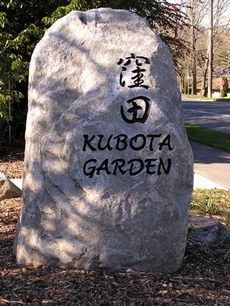
WP2: B = the number of R's on the rock sign.
WP3: C = the total number of vertical posts on the moon bridge across the pond.
WP4: D = the number of full-sized rock steps leading up (don't count the final half-slab). Please take the time to go up the second set of steps (don't count them) and see what awaits you at the top. (This waypoint is not technically wheelchair accessible, but wheelchairs do get here. The slope up is a bit more than the 5% allowed under ADA.)
WP5: E = the number of rocks that are completely surrounded, but not covered, by water. The rocks to be counted are several inches above the surface. At some water levels, one rock may just barely break the surface; don't count that one. The pond has koi swimming around, and kingfishers have been seen taking a meal on occasion. The gardener has even seen an osprey fishing here, although it's a bit small for ospreys.
WP6: F = the number of bridge sections over this pond, which is the same as the number of arches on one of the sections.
Cache: Ammo can at N 47° 30.[C-E]EF W 122° 15.DB[A-D]
