Cinovec EarthCache
-
Difficulty:
-

-
Terrain:
-

Size:  (not chosen)
Related Web Page
Please note Use of geocaching.com services is subject to the terms and conditions
in our disclaimer.

 An old mine remembered
CINOVEC / ZINNWALD
A continuous mountain massif of the "Krušné hory"
(Ore Mountains) is located on the border of the Czech Republic and
Germany. The mountain range on the northwestern border of the
country is approximately 81 miles (130 km) long. The volcanic
activity that accompanied the Ore Mountains creation in the
Paleozoic Era manifested itself by a vast presence of mineral
resources and healing springs, which had become the base for
balneotherapy treatment centers.


Occurrences of tin and tungsten mineralization have been
explored and exploited at the Czech and German parts of the
Krušné hory/Erzgebirge Mts. for several centuries. The
deposits are hosted in apical parts of strongly evolved Variscan
Li-F granites, which represent final fractionation products of the
magmatism belonging to the so-called Younger Intrusive Complex
(YIC). To the renowned localities of this type belong
Cínovec/Zinnwald, Altenberg. At the end of the 20th century became
greisen stocks Cínovec, the best-opened mines in the country. The
long vertical profiles and large data set collected in course of
the exploration works offer a rare opportunity to study geological
setting of greisen bodies and their relation to strongly
fractionated Li-F granites. This paper focuses mainly, but not
exclusively, on the petrographic and geochemical development of the
rocks with depth, as well as the relative role of igneous processes
vs. metasomatism in the genesis of the Li-F granites and the
related mineralization.
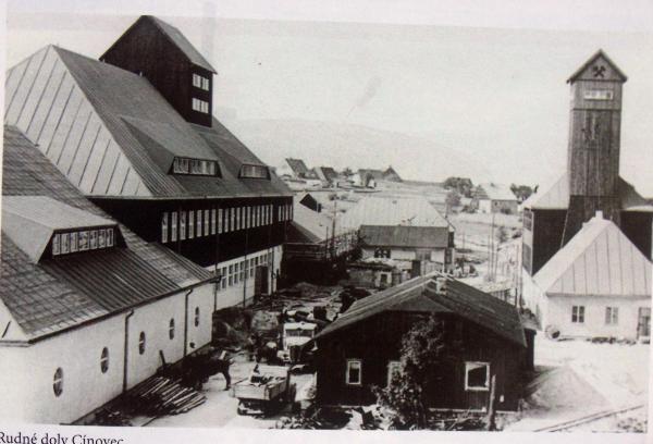
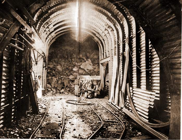
You are standing on the site of the former underground mine
"Cínovec 2." There was one 360m deep hoisting shaft with one
winding machine in the mine. The shaft was equipped with two
double-deck cages. A preparatory and explorative mine working was
undertaken in mine C ínovec 2 as well as in the mine Cínovec 2.
Mining here ceased due to a lack of commercial interest on 21st
November 1990, when the last loaded trolley arrived at the
pithead.

The deposit, where tin and tungsten rich ore seams had been mined
for several centuries was reutilized from 1945 until 1979, when the
iron seam became exhausted. After the discovery of a deposit at
Cínovec South, a new tin and tungsten rich ore mining development
was established. Preparatory working of the deposit for mining
began and the significance given to the geological research was
rewarded by the economically viable quantities of iron ore
discovered.
Questions about the mine Cínovec 1:
1. What was originally mined here?
2. In what century did the mine working start?
3. What was the altitude of Basic Cínovec?
4. What is found in the place of the former mine?
Email your answers to josef.zdich@seznam.cz (the topic - Earth)
Remember to add a photo of the place (see spoiler)
 Hornická vzpomínka
CINOVEC / ZINNWALD
Rozsáhlý horský masiv "Krusne hory" (Ore Mountains) se
nachází na sevrní hranici Ceské republiky a Nemecka. Horské pásmo
na severozápadním okraji zeme je približne 81 míle (130 km)
dlouhé. Sopecná cinnost zde doprovázela vznik Krušných hor
vytvorené v prvohorní epoše predstavující obrovskou
prítomnost nerostných bohatství a lécivých pramenu, které se staly
základem pro balneoterapii v lázenství.
Výskyty cínu a mineralizace wolframu byly prozkoumavané a
využívané v ceských a nemeckých cástech Krusných hor po
nekolik století. Žíly techto rud se vyskytují v apikálních
vrcholových cástech silne vyvinutých Variscan Li - F žul,
které predstavují finální rozdelení na cásti produktu magmatu
patrící tzv . Younger Intrusive Complexu (YIC). Podstatná a
duležitá místa tohoto výskytu patrí Cinovec/Zinnwald a
Altenberg. Na konci 19. století se zapocalo s težbou na dole
Cinovec, hlubinou težbou. Výskyt podélný rezu rudné žíly
a obsáhlé práce na vrtných pruzkumech nabízejí vzácnou
príležitost ke studiu geologického rozložení rudných
žil a jejich vztah k mocnosti delení na Li - F žuly.
Tento výzkum se zaostroval hlavne, ale ne výlucne, na petrografický
a geochemický vývoji rud s hloubkou urcenou pro težbu, stejne
jako rolí procesu utvárející metasomatóza v genezi Li - F žul
a související mineralizace. Následne melo být zapocato s
težbou speciálními metodami zkoumanými na dole Alternberg, kde
se zapocalo s težbou v oblasti Pinka.
Stojíte na míste bývalé hlubinné šachty Cínovec 2.
Šachta mela jednu težní jámu, hlubokou 360m, s jedním
težním strojem. Jáma byla vybavena dvema dvouposchodovýmu
klecemi . V šachte byly provádeny pruzkumné a prípravné
práce pro težbu Stejne jako šachta Cínovec1 ,byla i
tato uzavrena pro nezájem o težbu . 21.listopadu 1990 vyfáral
poslední vyrubaný vozík.
Rudná žíla bohatá na cín a rudy wolframu byly na Cínovci
težené pro nekolik století v období 1945 až 1979, kdy se
rudná žíla vycerpala. Po objevu rudy v oblasti Cinovec jih,
vznikla nová cínová težište a bohaté na rudy wolframu.
Byl ustanoven vývoj nových težebních prací. Zacaly zde
prípravné práce vzniku dolu pro težbu a byl uskutecnen
geologický výzkum. Bylo zjištené velké a ekonomicky výrazné
množství železné rudy.
Otázky se týkají šachty Cínovec 1.
1.Co se zde puvodne težilo?
2.Od kterého století zde probíhala težba.
3.Jaká je nadmorská výška Zadního Cínovce.?
4.Nezapomente po odsouhlasení správných odpovedí pridat do logu
foto z tohoto místa-N 50°43.385,E13°46.492(viz.spoiler)
Odpovedi posílejte na email: josef.zdich@seznam.cz s
predmetem:EARTH
Additional Hints
(Decrypt)
sbgbuvag