Location: Glastonbury,Connecticut N
41o 42.8657’, -072o28.1802’
(parking area)
Date listed:
Waymark Code:
Listed by: CTGEOSURVEY
Purpose: This EarthCache is created by the Connecticut
Geological and Natural History Survey of the Department of
Environmental Protection. It is one in a series of EarthCache
sites designed to promote an understanding of the geological and
biological wealth of the State of Connecticut.
Directions: From Route 2: take exit 8 to route 94
east. Follow Hebron Ave (rte. 94) eastward for 6.5
miles. Turn left (north) onto Birch Mountain Road.
Follow Birch Mountain Road 0.5 (one-half) mile north to a gate,on
the left, for a utility company’s right-of-way (ROW) access
road under the power lines. Park near the gate to start the
Earth Cache.
Long Description: The following directions will guide you
to your first destination at coordinates N.
41o 43.0398’, -072o
28.4693’. Pass around the gate and follow the
dirt roadwest. As the road winds (it will cross the newly
relocated Shenipsit Trail at marker #56), an outcrop will come into
view. Continue to follow the road as itloops around and to
the top of the outcrop.  The road will continue west while a
trail (the old Shenipsit Trail) continues north into the woods
. Follow the trail north about 250 yards (it runs parallel to
a stone wall in the distance to the west which you may not be able
to see when the trees are vegetated). The trail will lead you
to the coordinates above where it intersects with the blue-blazed
(relocated) Shenipsit Trail. Arriving at your location large
boulders should be in plain sight (Figure 1, the Shenipsit Trail
passes between the boulders). Walk around them and take a good
look. They appear to be composed of white, black, and clear
minerals,
The road will continue west while a
trail (the old Shenipsit Trail) continues north into the woods
. Follow the trail north about 250 yards (it runs parallel to
a stone wall in the distance to the west which you may not be able
to see when the trees are vegetated). The trail will lead you
to the coordinates above where it intersects with the blue-blazed
(relocated) Shenipsit Trail. Arriving at your location large
boulders should be in plain sight (Figure 1, the Shenipsit Trail
passes between the boulders). Walk around them and take a good
look. They appear to be composed of white, black, and clear
minerals,
Figure 1. Two largeboulders. Image was taken to
the east of the boulders along the Shenipsit Trail (notice blue
blaze on tree in middle). Boulders are composed of light gray
granitic gneiss.
probably feldspar, biotite, and quartz respectively. The
largest of the boulders (about 8 feet tall) is quite angular.
This would lead us to believe that it has not traveled very
far. As rocks are transported by gravity, water, or a glacier
they become rounded. This is because as they travel, the
edges are chipped away from contact with other rocks. After
you are done examining the rocks, look around at the surrounding
landscape. You are standing at the highest elevation around;
i.e. there are no higher areas near-by from where these rocks could
have rolled. Certainly a torrent of water necessary to move the
boulders would not flow at the top of a hill or ridge. The rest of
the EarthCache will enable you to determine where the boulders came
from and how far they may have traveled.
To find coordinates N. 41o42.9448’,
-072o28.5108’, follow the trail back from
where you came. As you are walking look for other boulders
much smaller in size. The trail passes between two boulders
directly opposite one another just before coming to the ROW.
The larger of the two, which is on your left, is the one of
interest (see Figure 2). Inspect the rock and the area on the
trail in front of it. You should notice that the rock is very
similar in composition to the larger boulders we have already
seen. At the base of the rock we can see that the bedrock on
which the boulder sits and the boulder are of different
lithology. The bedrock is dark gray colored schist of the
Littleton Formation. It is a medium-grained mica schist with
millimeter size garnets and 2.5 cm long staurolite 
Figure 2. Boulder of light
gray granitic gneiss sits on top of dark gray mica
schist. Can you find the 15 cm pencil used for scale
(it is standing on its point. Hint: try
enlarging the magnification on your screen??
crystals. The schist was once mud at the bottom of the
Iapetos Ocean. The mud was subjected to intense heat and
pressure and was metamorphosed into this schist. The garnet
and staurolite crystals indicate that there were high amounts of
iron and aluminum present during metamorphism and that the
temperature and pressure during metamorphism was moderate to
high. Continue to follow the trail south and keep your eyes
on the ground. You may see parallel grooves in the bedrock
you are walking on.
As you come out of the woods at the utility company ROW, you
will have reached the spot of the next location. After
enjoying the view, inspect the rock on which you are
standing. Here you will find it easy to see a series of
parallel grooves in the schist bedrock (Figure 3). As you
look around more you see that these lines are quite
extensive. They cover the entire surface of the top of the
bedrock. They can also be found on outcrops in the woods and
down the hill in the ROW.

Figure 3. Glacial
grooves and striations on surface of Littleton Schist at edge of
ROW. Foliation (feet of geologist are on top of weathered
foliation plane) cuts across the rock at almost 60o to
the orientation of the grooves. Glacial groove orientation is
S. 38oE (142o) at this
location.
Notice that the grooves are at an angle to the layering
(schistosity foliation) in the gray Littleton Schist. What could
have created these? Grooves could be etched into the rock
from off road vehicles (and some are present near-by). To be
certain of their origin you may want to walk into the woods again
along the trails to see similar grooves (if you follow the
Shenipsit Trail north about a mile, many outcrops containing
glacial grooves and striations will be crossed). They were
not made by machines. These are called glacial
striations. They are formed when rocks and other debris
frozen into the base of the glacier gouged into the bedrock as they
were being dragged along the bottom of the glacier and ground
up.
Striations indicate the last direction the glacier was
moving: the ice moved parallel to the striation. They
only indicate the last ice flow direction because a change in
direction during the retreat of a glacier may have obliterated
earlier directional indicators. It turns out that these particular
striations and grooves record average ice movement direction during
the ice age.
Figure
4A.
Figure 4B.


Figure
4A.
Chatter marks developed along the
grooves and striations by a large rock(s) frozen into base of
glacier that “bounced” as it gouged into the underlying
ledge (red pocket knife is ~9 cm long [3.5”]). Grooves
are oriented S.38oE (SE is toward top of both A. and
B.)
Figure 4B. Chatter mark
(at point of pen) that may be lunate shaped indicating movement was
toward the SE (top). Cresentic gouges (convex side points in
direction from which the glacier came) indicating SE ice movement
are also reported from the area.
As the striations are linear features, the ice theoretically
could have been moving in either direction. A closer look
(Figure 4) at some of the striations located closest to the power
lines, one may notice that it appears as though some grooves
contain “chatter marks” (see definition in caption for
Figure 4), some of which have been chiseled out into half-moon
shapes (lunate) whose convex side points in the direction toward
which the glacier moved. Toward what direction would the ice
have moved? Movement from the northwest is consistent with
data found in other areas nearby.
 Now we have all the information we need to
infer the origin of the large boulders we encountered at the
beginning of this exercise. The ice was last moving from the
northwest. The bedrock map of the Marlborough Quadrangle
(Figure 5) shows the Glastonbury Gneiss underlies a large area to
the northwest of our location. The Glastonbury gneiss is a
gray medium-grained gneiss with quartz and feldspar. This
would explain the mineral composition we noted when first examining
the boulders. The closest mapped outcrops of contact between
the gneiss and the schist are ~1/2 km away. A rock that has
been transported by a glacier and is resting on bedrock of
different lithology is known as a glacial erratic. We now
know that the boulders are really glacial erratics that have been
transported at least 1/2 km from their source to the northwest.
Now we have all the information we need to
infer the origin of the large boulders we encountered at the
beginning of this exercise. The ice was last moving from the
northwest. The bedrock map of the Marlborough Quadrangle
(Figure 5) shows the Glastonbury Gneiss underlies a large area to
the northwest of our location. The Glastonbury gneiss is a
gray medium-grained gneiss with quartz and feldspar. This
would explain the mineral composition we noted when first examining
the boulders. The closest mapped outcrops of contact between
the gneiss and the schist are ~1/2 km away. A rock that has
been transported by a glacier and is resting on bedrock of
different lithology is known as a glacial erratic. We now
know that the boulders are really glacial erratics that have been
transported at least 1/2 km from their source to the northwest.
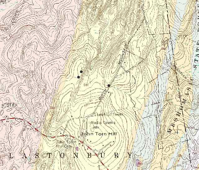
Figure 5. Geologic map
of a portion of the Marlborough Quadrangle showing Birch Mountain
Road. The pink area on the map is underlain by Glastonbury
Gneiss; the areal extent of the Littleton Schist is shown in
yellow; two of the black dots show the GPS-locations of our
observations and the third shows the parking area on Birch Mountain
Road.
How to log this EarthCache:
1.What is the weight of the largest boulder illustrated in
Figure 1? To answer this estimate the volume of the boulder by
estimating its average dimensions (length, width, and height). It
is an irregular shape so this may present a challenge. For instance
the boulder is about 8 feet high at its highest, but the average
height may only be about 6'...or 5 1/2 feet or more or less. Then
multiply the average length times the average width times the
average height. A rule of thumb that stone masons use is that a
stone wall 2' x2' x3' weight about a ton (a ton is 2000 pounds).
So, dividing the volume by 12 should give you the weight of the
stone in tons.
2. Accompany your answer with a picture. First lay your GPS
along one of the striations so that its antenna points in the
direction toward which the glacier moved. Take a picture showing
your GPS unit and the striation. Determine the bearing of that
direction. A measurement is preferred but if you cannot do that
with your instrument chose from the following: E (090°), ESE
(112.5°), SE (135°), SSE (157.5°), S (180°), SSW (202.5°), SW
(225°), WSW (247.5°), or W (270°).
3. Optional: Submit a picture of you or a member of your party
doing this EarthCache if you would like us to post it on our
Geology Webpage at the Connecticut Department of Environmental
Protection. We are particularly interested in developing activities
that families can do together, and want to show that EarthCaches
are a fun way to get outdoors.
Difficulty: 1
Terrain difficulty: 3
References:
Bell, M., 1997, The Face of Connecticut, Connecticut
State Geological and Natural History Survey, p. 124-125.
Bennett, M.R., and Glasser, N. F., 2003, Glacial Geology, Ice
Sheets, and Landforms, 109-115.
Snyder, G.L., 1970, Bedrock Geologic and Magnetic Maps of the
Marlborough Quadrangle East-Central Connecticut (1:24,000), U.S.
Geological Survey Geologic Quadrangle Map GQ-791.
Stone, J.R., Schafer, J.P., London, E.H., DiGiacomo-Cohen, M.L.,
Lewis, R.S. and Thompson, W.B., 2005, Quaternary Geologic Map of
Connecticut and Long Island Sound Basin (1:125,000), United States
Geological Survey Science Investigation Map #2784.
This EarthCache was written by
Earl Manning in 2008 while he was an undergraduate student at
Central Connecticut State University and working part time for the
State Geologic and Natural History Survey of Connecticut. He
enrolled in the Graduate School at the University of Oklahoma in
the Fall of 2009.
The Kongscut Land Trust
graciously gave permission to publish this EarthCache on land under
their stewardship.