|
   |
|
|
| Map |
 |
| Budapest |
|
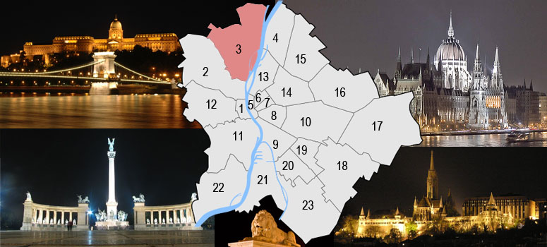
Budapest is a city of multiple characters, different geographical areas and of wide variety of architectural styles. The current city was established on 17th November, 1873 by the unification of the settlements of Pest, Buda and Óbuda on the banks of the Danube river. Budapest had 10 districts after coming into existence in 1873, numbered 1 to 10. In the 1930s, 4 new districts were organized, numbered 11 to 14. On 1st January, 1950, Budapest was united with 7 neighbouring towns and 16 villages, hence the number of its districts increased to 22. In 1994, one of the former villages left district 20 in order to form the 23rd district. Budapest's current 23 districts extend to an area of 525 square kilometres (202.7 sq mi). Most of the districts have a special flavour - from a posh downtown area one can get easily into the hilly districts of Buda or to the green suburbs of Pest. Several districts still bear the marks of the enforced industrialization of the 50s and 60s. City parks, forests of the Buda Hills, boat-houses along the Danube, flowery islands, shipyards and chemical plants, the Royal Castle and prefab housing estates are all part of this wonderful city.
The Great Budapest Geocaching Adventure guides you through all 23 districts with the goal of displaying the most typical or most unique sites in each of them. In each cache there is a code you need to uncover for the real coordinates of the bonus cache. You can find the codes on the inside of the lids of each cache container and in the logbooks. Happy caching!
|
| The 3rd district |
|
Budapest’s 3rd district is situated on the right bank of the Danube. The District Municipality is using the name Óbuda-Békásmegyer. The Óbuda island, where the famous Island Festival (Sziget Fesztivál) is held annually, belongs to the district.The district is divided into halves by the Bécsi út, the western part is hilly, the eastern is plain. The centre of this district is the area of Flórián Square and Fö Square, where mainly prefab housing estates are present, though there are green areas as well. The name Óbuda. means Old Buda in Hungarian. Settlements were present in this area from the Stone Age. The Romans built here Aquincum, the capital of Pannonia Province. Hungarians arrived to the site after 900 and it served as an important settlement of major tribal leaders, later kings. Béla IV of Hungary built a new capital after the 1241-1242 Mongol invasion in Buda, somewhat south of Óbuda. On January 1, 1873 it was united with Buda and Pest to form Budapest.
|
 |
|
|
| The hiding place |
|
"The Roman Beach Old Buda [Danube] the northern half of his part. His length some 10 km because of the estuary of the friend brook it Aranyhegyi-patak lasts until his estuary. More punctually from the Újpest railway bridge a Whitsun bath reaches as far as port. Római-part one of Budapest's quarters the III. in circumference.
The Roman Beach means one to Old Buda and the capital's population with Danube, the sport, the relaxation, with the recreation and the boathouses. The Római coast was the trendy centre of the Buda aquatic life earlier, that pollutingmentes, place was suitable for bathing. They brought the swimming areas to an end in 1973 because of the decay of the water quality. Now here many boathouses, boat lender and increasingly more clubs, restaurant, pub can be found for the excursionist and the water sports' lovers. The Danube coast the watercycling and running place liked beside sports. Remained and working boathouses: Lapwing, Tropical, Star, Peace, Swan, Bibic.
The Római coast was the trendy centre of the Buda aquatic life. Once pollutingmentes, place was suitable for bathing. Now many boathouses and increasingly more clubs, restaurant can be found here for the excursionist and the lovers of the water sport's. From the Újpest railway bridge a Whitsun bath reaches as far as port. The Római coast was the trendy centre of the Buda aquatic life. Once pollutingmentes, place was suitable for bathing. Now many boathouses and increasingly more clubs, restaurant can be found here for the excursionist and the lovers of the water sports.
|
| Approaching: |
 Light railway: Get off at Aquincum, Rómaifürdö, Csillaghegy or Békásmegyer. From there it's a good 10 mins of walking. Light railway: Get off at Aquincum, Rómaifürdö, Csillaghegy or Békásmegyer. From there it's a good 10 mins of walking.
Bus: a 34 bus moves on the Kings' road onto Békásmegyer. Any Kings' roads getting off to a couple of minutes here at a stop the coast. from the Nánási travel stop of a 106 bus under 2 minutes available the coast.
MÁV: Aquincum is needed at a stop to fall, to walk over on the housing estate and there the coast.
Boat: (visit link).
 Bicycle: Your saint on cycle track heading towards it. (visit link) Bicycle: Your saint on cycle track heading towards it. (visit link)
 You can parking free at this coordinates see them at waypoints: N 47° 34.435' , E 019° 03.782' You can parking free at this coordinates see them at waypoints: N 47° 34.435' , E 019° 03.782' |
| Budapest |
|
Budapest ist eine Stadt bunten Charakters, unterschiedlicher geographischer Zonen und einer breiten Vielfalt an architektonischen Stilen. Die heutige Stadt wurde am 17. November 1873 durch Zusammenschluss der Städte Pest, Buda und Óbuda, die an beiden Ufern der Doanu liegen, gegründet. Budapest hatte damals 10 Bezirke, nummeriert von 1 bis 10. In den 30er-Jahren kamen 4 weitere Bezirke (11-14) hinzu. Am 1.Jänner 1950 wurde das Stadtgebiet um angrenzende 7 Städte und 16 Dörfer erweitert, die Zahl der Bezirke erhöhte sich damit auf 22. 1994 wurde eines der früheren Dörfer aus dem 20. Bezirk ausgegliedert, womit ein neuer 23. Bezirk enstand. Die derzeit 23 Bezirke haben eine Ausdehnung von insgesamt etwa 525km² (202,7mi²). Die meisten dieser Bezirke haben ihren unverwechselbaren Charakter - von repräsentativen Innenstadtbereichen über die hügeligen Bezirke von Buda bis hin zu den erholsamen grünen Vorstädten von Pest ist alles zu finden. Einige Bezirke stehen bis heute im Zeichen der stark forcierten Industrialisierung der 50er- und 60er-Jahre. Stadtparks, die Wälder der Budaer Berge, Bootshäuser entlang der Donauufer, blütengezierte Inseln, Werften und Chemiebetriebe, die königliche Burg und auch Fertigteil Wohnhausanlagen sind alle Teil dieser wundervollen Stadt.
Das Große Budapester Geocaching Abenteuer wird durch jeden der 23 Bezirke führen und versuchen, in jedem etwas Typisches oder Einzigartiges zu zeigen. Jedem, der alle 23 Caches besucht, winkt als Draufgabe ein BONUS-Cache. Viel spass.
|
| 3. Bezirk |
|
Das III. Bezirk in Budapest liegt auf der richtigen Küste der Donau, auf der Buda Seite. Die Bezirkskommunal Verwaltunges verwendet die Name Óbuda (Alt-Ofen)-Békásmegyer. Die Óbudai Insel gehört seinem Gebiet, wo es auf dem Ende des Sommers "Sziget Fesztivál" behalten wird. Der Kreisumfang von einem Entlastungsgesichtspunkt die Achse, die durch Bécsi út begrenzt ist, spaltet es in zwei scharf.
Wegen dieser Linie nach Westen, Die Buda Hügel und Pilis baucht sich. Nach Osten andererseits finden wir ein flache Gebiet, dass die größten Überschwemmungen der Donau, die an Dämmen in einem Maß Mangel hat, überschwemmen würden. Das Zentrum des Kreisumfangs sind Flórián tér und Fö tér Bezirk, wo Wohnsiedlungen gefunden werden können, aber gibt es einen Garten, Familienhauszone hier.
|
|
| Das Versteck |
|
Die Római Küste, Alter Buda [die Donau] tötet die nördliche Hälfte seines Teils. Seine Länge ungefähr 10 km wegen der Flussmündung des Freunds erdulden es Aranyhegyi-patak, dauert bis zu seiner Flussmündung. Pünkösdfürdö streckt sich bis zu den Hafen von der Újpest Eisenbahnbrücke pünktlicher aus. Die Római Küste bedeutet denjenigen zu Altem Buda und der Haupstadt Bevölkerung mit der Donau, dem Sport, der Entspannung, mit der Unterhaltung und den Bootshäusern.
Die Római Küste war früher das moderne Zentrum des Budaer Wasserlebens. Wegen des Zerfalls des Wassers wurde das Benennenden Küste es zu einem Ende 1973 gebracht. Jetzt hier sind viele Bootshäuser, zunehmend mehr Klubs, Restaurant. Hier kann man Radfahren, und laufen. Gebliebene Bootshäuser sind: Bibic, Tropisch, Stern, Frieden, Schwan. Diese Bootshäuser sind sie an einem Stillstand unter dem Schutz!
|
| Verkehrsverbindung: |
Römische Küste Von der Árpád Brücke kann man mit der Busse Nr. 106 und 134 fahren, oder von der Batthyány Platz kann man mit der "HÉV" benutzen.
Von der Vigadó Platz kann man mit dem Schiff nach Békásmegyer bis Pünkösdfürdö zu fahren. (visit link).
Auf diesem Webseite kann man Farhradweg zu finden: (visit link)
Auf diesen Koordinaten kann man freie Parkplatze zu finden: N 47° 34.435' , E 019° 03.782' |
| Budapest |
|
Budapest ezerarcú város, melyet földrajzi változatossága és építészeti sokszínüsége varázsol egyedivé. Az 1873. november 17-én Pest Buda és Óbuda egyesítésével létrejött akkori fövárosnak 10 kerülete volt, amely az elkövetkezö évtizedek során fokozatosan bövült a mai 23-ra. A város ma 525 négyzetkilométeren terül el. A különbözö kerületek a folyamatos fejlödés és átalakulás mellett tovább örzik sajátosságaikat, a Belváros csillogó bevásárló utcái, Buda dombvidéke vagy a pesti zöldövezet lakónegyedei mind sajátos hangulattal bírnak. A város arcát továbbra is sebhelyként csúfítják az 50-es, 60-as évek eröltetett iparosításának "emlékmüvei". Zöld parkok és ligetek, a Budai hegyvidék erdöi, Duna-parti csónakházak, virágos szigetek, hajógyárak és vegyi üzemek, a Budavári palota és panel lakótelepek - ez mind Budapest.
A Nagy Budapesti Geocaching Kaland végigvezet mind a 23 kerületen bemutatva az adott városrész legjellegzetesebb vagy éppen a legfurcsább vonásait. Ha mind a 23 ládát megtalálod, indulhatsz a BONUS láda megkeresésére. Kalandra fel!
|
| III. kerület |
|
Budapest III. kerülete Budapesten a Duna jobb partján, a budai oldalon fekvö kerület. A kerületi önkormányzat az Óbuda-Békásmegyer nevet használja. Területéhez tartozik az Óbudai-sziget is, ahol minden nyár végén megtartják a méltán hires "Sziget Fesztivált". A kerületet domborzati szempontból élesen kettéosztja a Bécsi út által határolt tengely. E vonaltól nyugatra a Budai hegység és a Pilis domborulatai kezdödnek. Keletre viszont sík területet találunk, amelyet a Duna legnagyobb áradásai gátak híján jelentös mértékben elöntenének. A kerület központja a Flórián tér és a Fö tér körzete, ahol föként lakótelepek találhatóak, de van itt kertes, családi házas övezet is.
|
|
|
| A rejtekhely |
|
"A Római-part" Óbuda [Duna] felöli részének északi fele. Hossza mintegy 10 km a Barát-patak torkolatától az Aranyhegyi-patak torkolatáig tart, pontosabban az Újpesti vasúti hídtól Pünkösdfürdö hajóállomásig terjed. Római-part Budapest egyik városrésze a III. kerületben.
A Római-part Óbuda és a föváros lakosságának egyet jelent a Dunával, a sporttal, a pihenéssel, a kikapcsolódással és a csónakházakkal. Régebben a Római-part a budai vízi élet felkapott központja volt, amely szennyezésmentes, fürdésre alkalmas hely volt. A vízminöség romlása miatt a kijelölt fürdöhelyeket 1973-ban megszüntették. Most itt rengeteg csónakház, csónakkölcsönzö és egyre több szórakozóhely, étterem, sörözö található a kirándulók és a vízi sportok szerelmesei részére. A Duna-part a vizi sportok mellett kedvelt kerékpáros és futó hely is. Megmaradt és müködö csónakházak: Bibic, Tropical, Csillag, Béke, Hattyú. Ezen csónakházak jelenleg is müemléki védelem alatt állnak!
|
| Megközelítés: |
HÉV: Aquincum vagy Rómaifürdö, Csillaghegy és Békásmegyer megállóktól lehet megközelíteni kb. 10-15 perces gyaloglással együtt.
Busz: 34-es busz a Királyok útján halad Békásmegyerre. Bármelyik Királyok útjai megállónál leszállva pár percre itt a part. A 106-os busz Nánási úti megállójától 2 perc alatt elérhetö a part.
MÁV: Aquincum felsö megállónál kell leszállni, átsétálni a lakótelepen és ott is a part.
Hajó: A BKV hajójárattal Rómaifürdö - Csillaghegy - Pünkösdfürdö útvonalon a BKV által üzemeltetett hajóval is megközelíthetö Április 11-e és Október 4-e között. Budapesten belvárosi felszállóhelyek a hajókra: Boráros tér - Petöfi tér - Batthyány tér - Jászai Mari tér. Menetrend és viteldíjak a külsö hivatkozásoknál.
Autóval: Szentendrei út felöl a Duna felé haladva. (útvonalterv).
Kerékpár: Szentedre felé tartó kerékpárúton. (térkép)
Ingyenes parkolási lehetöség az útpontoknál megjelölt koordinátákon található: N 47° 34.435' , E 019° 03.782' |