"Where
51 Ends and the Fun Begins!"
 The Hurley, WI
area provides an opportunity to examine the geology of the
southern portion of the ancient Superior continent as well as
a century of iron mining. Part of the crust of the old
Superior continent is exposed in pink and gray glacially
polished and striated Archean granite (gneiss) bedrock
outcrops in the area that are older than 2,500 million years
old. During the Archaean time period the atmosphere was
very different from today; at that time, it was a reducing
atmosphere of methane, ammonia, and other gases. Also during
this time, the Earth's crust cooled enough that rocks and
continental plates began to form.
The Hurley, WI
area provides an opportunity to examine the geology of the
southern portion of the ancient Superior continent as well as
a century of iron mining. Part of the crust of the old
Superior continent is exposed in pink and gray glacially
polished and striated Archean granite (gneiss) bedrock
outcrops in the area that are older than 2,500 million years
old. During the Archaean time period the atmosphere was
very different from today; at that time, it was a reducing
atmosphere of methane, ammonia, and other gases. Also during
this time, the Earth's crust cooled enough that rocks and
continental plates began to form.
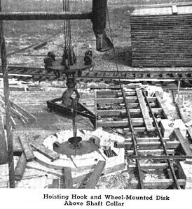
The nearby Cary Mine
operated for about 78 years. During its active life, the mine
produced and shipped millions of tons of high-grade ore. A vertical
shaft was developed in the 1940’s using the latest technology that
consisted of a large shot drill 5’6” in diameter. The bore hole was
drilled to a depth of 2500 feet in solid granite taking over 2
years continuously running 24 hours a day, 7 days a week. Each time
a section of core was removed, the entire drill and drilling
machine had to be removed from the borehole. The mine closed in the
1960s when the steel industry changed from using high-grade iron
ore from deep shaft mines to using the more abundant taconite ore
that could be economically mined by the open-pit method.
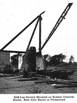 Mr. J. B. Newsom,
a prominent mining engineer, conceived the idea of the shot
drill bit. The borehole at Hurley is the third time this
method has been used and is the largest undertaking of the
three. Debut of the Newsom drill was in 1936 at the Idaho
Maryland Mine in California. The drill was 5'0" in diameter
then, and took 21 months to drill 1,125 feet in serpentine
rock. Venture number two was in 1938 at the Zenith Mine on the
Vermilion Range, Ely, Minnesota (see Earthcache
GCNXZG
). Here a 1,208-foot hole was bored in greenstone within seven
months, using a higher-powered, 5'6" diameter drill. The drilling
is accomplished by using steel shot smaller than bird shot, which
are abraded against the rock by the bit as it is rotated. Since the
shot is considerably harder than the low carbon-cutting shoe,
pellets of shot embed themselves in the bottom of the cutting edge
as it turns, scraping and abrading the rock. As the core barrel
rotates, it cuts a circular slot about 2 inches in width around the
core. When a core has been cut to a depth of about 10 feet, the
operator disconnects the air and power lines and the drill is
lifted to the surface and swung away from the collar. The core is
broken off by wedging it to one side, and is then removed by means
of a core-puller.
Mr. J. B. Newsom,
a prominent mining engineer, conceived the idea of the shot
drill bit. The borehole at Hurley is the third time this
method has been used and is the largest undertaking of the
three. Debut of the Newsom drill was in 1936 at the Idaho
Maryland Mine in California. The drill was 5'0" in diameter
then, and took 21 months to drill 1,125 feet in serpentine
rock. Venture number two was in 1938 at the Zenith Mine on the
Vermilion Range, Ely, Minnesota (see Earthcache
GCNXZG
). Here a 1,208-foot hole was bored in greenstone within seven
months, using a higher-powered, 5'6" diameter drill. The drilling
is accomplished by using steel shot smaller than bird shot, which
are abraded against the rock by the bit as it is rotated. Since the
shot is considerably harder than the low carbon-cutting shoe,
pellets of shot embed themselves in the bottom of the cutting edge
as it turns, scraping and abrading the rock. As the core barrel
rotates, it cuts a circular slot about 2 inches in width around the
core. When a core has been cut to a depth of about 10 feet, the
operator disconnects the air and power lines and the drill is
lifted to the surface and swung away from the collar. The core is
broken off by wedging it to one side, and is then removed by means
of a core-puller.
Located at
the
Wisconsin Travel
Information Center are sections
of these large Archean granite (gneiss) cores that have dark
angular fragments of older metamorphic rock that was intruded by
granite. They are arranged around a huge sundial that depicts
the growth and decline of iron mining in Wisconsin.
As time is measured
mining has three principle periods, Discovery, Development and
Decline. You will be standing on a giant sundial placed as a
dynamic reminder of the mining area in Iron County and other mining
communities on the Gogebic Range. The morning shadow depicts the
New Dawn of Discovery. At noon the sun and mining are at their
zenith. The waning sun foretells the inevitable decline of every
mining operation.
TO LOG
THIS CACHE:
1) During its active life, the mine
produced and shipped how many tons of high-grade
ore?
2) What’s the estimated
percentage the darker metamorphic rock to the intruded granite in
the largest core?
To log this cache
e-mail me the
answer
HERE
.
Sources:
- Baird, Jerome E. (ed.) /
The Wisconsin engineer Volume 47, Number 1 (October, 1942)
Erspamer, Gordon New Cary mine shaft, pp. 4-5
- Dott, R.H. and J.W. Attig
(2004). Roadside Geology of Wisconsin. 400
p.
- McBride, Sarah Davis. 1999.
History Just Ahead. Wisconsin Historical Society
–Madison.