Hveragerdi Hot Springs EarthCache
rjm1: The hot springs have been deteriorating over the years since this earth cache and sadly it is no longer the attraction it once was.
-
Difficulty:
-

-
Terrain:
-

Size:  (other)
Please note Use of geocaching.com services is subject to the terms and conditions
in our disclaimer.
Please note - The geothermal area in Hveragerdi is not accessible by the public at all times. The area has been fenced to protect the public and animals from the potential danger of falling into the hot area.
At the time of the publication of this Earthcache, the area was open Monday to Friday from 10:00 to 18:00 and on Saturdays and Sundays 12:00 to 16:00. From May 2013 an entrance fee is charged which is now 300 ISK.
We have been advised that the park is closed for winter between September and May. I believe it is still possible to answer the questions (some teams have) and a photo taken near the Park sign will be acceptable. Alternatively, I think the Tourist Office might open the Park if you are really keen. It seems some of the hot springs have dried up in 2013 but the information required for the Earthcache is still available.
The Hveragerdi geothermal area provides an easily accessible and safe environment to investigate many of the surface manifestations of geothermal activity in one place.
Background
The Earth's crust is divided into several thick plates that float on the mantle. These plates are formed at oceanic ridges where magma from the mantle rises up and comes to the surface in volcanic eruptions or solidifies at depth. The Mid-Atlantic ridge crosses Iceland from the south-west to north-east. The high production of magma is the reason for Iceland being above sea level. The volcanic rift zone enters Iceland in the Reykanes in the south-west and Hveragerdi is at the eastern margin of the volcanic zone. The plates are moving apart at the rate of 1 cm per year.
Hveragerdi
Hveragerdi is the only town in Europe with an active high temperature geothermal area in its middle. The area has been active for thousands of years and is constantly changing, due to earthquakes in particular. Hveragerdi is built on top of an old volcanic magma chamber and this accounts for the abundance of hot water and steam. Ground water filters through fissures and porous rocks in the surrounding lava fields and mountains. This in turn comes into contact with an underlying heat source with base temperature known to reach more than 200 degrees Celsius. The heated ground water then finds its way back to the surface via geysers, steam vents, mud pools and hot springs. In dry spells the hot springs and mud pools can change to steaming fumaroles and reverse when the water table rises again.
Uses of the thermal heat.
In 1929 it was first used in the Fagrihvammur greenhouse farm. The following year the Mjolkurbu Olfusinga dairy started using steam from the Bakkahver fumarole. In 1953 the Hveragerdi District Heating Service was established followed by the Icelandic Nature Health Association Clinic in which opened in 1955. The thermal heat is currently used to heat 50 000 cubic meters of greenhouses and provide space heating for 650 houses. There are 3 swimming pools in the town as well as health institutions. Several of the local shops sell 'hot spring bread' (Hverabruad) which is still baked using traditional methods utilising the geothermal heat.
The Geothermal Park
There are several information boards around the park. You will need to visit 3 to answer the following questions.
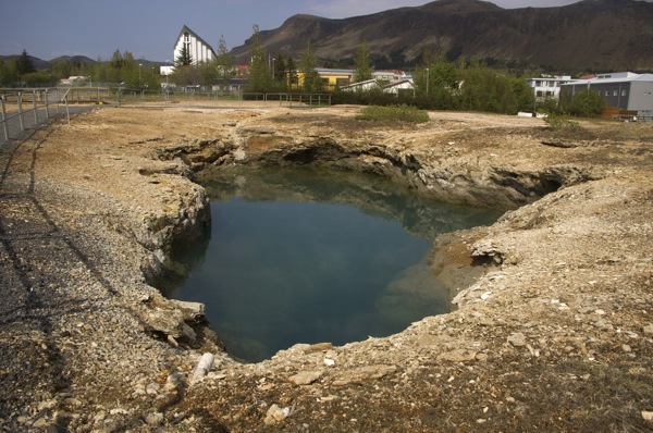
Blue Spring
Blue Spring
This spring is the biggest and best known hot spring in the area. Its name refers to its colour. The colour is due to colloidal silica in the water, as silica absorbs the sun's red waves lengths reflecting the green-blue colour to the eye.
Question One - What is the temperature range and pH of the Blue Spring?
The Bull's Eye
This is a typical mud hole that can be found in a High Temperature Area. In this mud hole you can find archaebacteria which can be recognised as an oily slick floating on the surface.
Question Two What is the name of the archaebacteria and how old are they? (optional as the sign seems to have disappeared)
Hot spring river from a hot water well
In 1989 Borehole HSO8 was drilled to a depth of 254 metres. Water from this bore creates the hot river found here. This alkaline hot spring river is home to cyanobacterias. This looks like dark green slime. The blue-green bacteria Mastigocladus laminosus, has its optimum growth temperature between 45 - 60 degrees Celsius. Next to this is the orange coloured Chloroflexus. This bacteria gets its colour from the hydrogen sulfide-depending photosynthesis that produces carotine. Both of these species are common in alkaline hot water springs.
Question Three Would you expect to find Mastigocladus laminosus and Chloroflexus in the Blue Spring? Briefly explain the reason for your answer.
Other points of interest
For a low fee, you can relax after a day of caching with a warm mud foot bath or boil an egg in the hot stream. See the Attendant for details.
If you wish to have a more intimate experience involving geothermal mud try the mud bath at the local NLFI Health Clinic and Spa. Team rjm1 recommend it.
To log this cache
1. Email the answers to the 3 questions listed above to rjm1.
2. If possible take a photo of yourself and/or GPS somewhere in the park. We would love to see what it looked like when you were there, however this is optional.
3. When you have confirmation that your answers were correct, log the find and upload your photo if you have one.
Logs without emailed answers to the questions will be deleted. Please ensure groups include each team name in the answers email to prevent their log being deleted.

Lillangen
Additional Hints
(No hints available.)