Skip to content

Reichenbacher Felsenmeer Earthcache EarthCache

This cache has been archived.

geoaware: This EarthCache has been archived because it no longer meets the EarthCache guidelines. If you wish to update this EarthCache, please reference the guidelines at www.earthcache.org. Once you have updated your listing, please email the EarthCache Approver at earthcache@geosociety.org.

More
Hidden : 6/27/2005
Difficulty:
1 out of 5
Terrain:
2 out of 5

Size: Size:   not chosen (not chosen)

Join now to view geocache location details. It's free!

Watch

How Geocaching Works

Please note Use of geocaching.com services is subject to the terms and conditions in our disclaimer.

Geocache Description:


Ein wirklich interessanter Ort zum Entdecken und Klettern / A really interesting place for exploring and climbing


Deutsch
Das Reichenbacher Felsenmeer ist Teil des "UNESCO Geo-Naturparks Bergstrasse-Odenwald". Entstanden ist das Felsenmeer vor ca. 340 Millionen Jahren. In der Subduktionszone kam es im Bereich des Oberen Erdmantels zur Bildung von Gesteinsschmelzen. Diese Schmelzen (Magmen) stiegen langsam aus der Tiefe aus und erkalteten in der Erdkruste als Plutonite (erstarrte Magma im Erdinneren).

Im Gebiet des heutigen Felsberg bildeten sich in einer Tiefe von 12–15km ein mächtiger Intrusivkörper aus Quarzdiorit. Dieses kristalline Gestein gehört zur Familie der Granitoide. Es besteht im wesentlichen aus den Mineralen Feldspat, Pyroxen, Hornblende und Quarz.

Der Quarzdiorit hatte eine Entstehungstemperatur von etwa 550°C und brauchte 10 Millionen Jahre bis zur Abkühlung auf 300 °C. Im Verlauf dieser Abkühlung kam es im Gestein durch Schrumpfungen zu ersten Rissen und Klüften.

Vor 280 Millionen Jahre waren diese Prozesse abgeschlossen und der Odenwald bildete ein Teil des Varistischen Gebirge, das sich quer durch Mitteleuropa erstreckte. Dieses Varistische Gebirge ist mit den heutigen Alpen vergleichbar.

Bis zum Tertiär (65 Millionen Jahren) wurde das überdeckte Gebirge (5–8km) abgetragen und der Quarzdioritkörper stieg bis zur Erdoberfläche auf. Gleichzeitig brach im Tertär der Rheingraben ein, was ein weiteres herausheben des Bergsträßer Odenwalds bewirkte. In Folge der Druckentlastung vertieften sich die schon vorhandenen Risse und Klüfte im Gestein und zerteilten den massigen Intrusivkörper in quaderförmige Blöcke. Der nun an der Oberfläche aufgeschlossene Quarzdiorit war jetzt der starken chemischen Verwitterung eines subtropischen Klimas ausgesetzt. Diese reichte bis in mehrere Zehnermeter Tiefe und führte zur randlichen Zersetzung der Gesteinsblöcke. Um die Blöcke reicherte sich das Verwitterungsmaterial, der „Grus“, an. Der Grus ist ein Gemisch aus Kies und Tonminerale.

Die heutige Form des Felsenmeers bildete sich aber erst in junger geologischer Zeit während der letzten Eiszeiten (Pleistozän). Vor etwa 12.000 Jahren in der letzten Eiszeit war der Odenwald nicht von Eis bedeckt, aber er lag in einem Permafrostgebiet (ähnlich Tundra). So konnte in den wärmeren Jahreszeiten der Boden auftauen und Wasser spülte die Felsblöcke von dem Grus frei. In den kalten Jahreszeiten gefror der Boden und es bildeten sich Eiskeile im Untergrund und in den Klüften der Blöcke. Der Quarzdiorit wurde praktisch auseinander gesprengt, es wirkte der Prozess der Frostverwitterung.
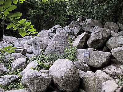
Die so freigelegten Blöcke kamen in Bewegung und glitten die Talflanken hinab und bildeten dort große Blockmeere, das Felsenmeer. Der Verwitterungsprozess, der den Gesteinsblöcken ihr typisches Aussehen verleiht, wird als „Wollsackverwitterung“ bezeichnet.

SiegfriedsquelleDie Römer haben den Granit der Gegend als Steinbruch benutzt, zum Beispiel für den Dom in Trier. Sie hinterließen dabei über 300 teilweise bearbeitete Steine, insbesondere eine römische Säule und den Altarstein. In manche teilbearbeitete Steinbrocken hat man Formen hineininterpretiert, so z.B. das Riesenschiff oder den Krokodilfelsen.

Weitere Informationen zum Felsenmeer findest du hier.

Zum Loggen dieses Earthcaches benötigst Du ein Foto Deinem GPS (und wenn möglich, von Dir selber) vor der "Siegfriedsquelle" (N49° 43.340 E8° 41.575) am unteren Ende des Felsemmeers. Logs ohne Foto werden leider gelöscht.

Von hier aus kannst Du übrigens auch weitere Caches angehen, z.B. den
Erliots "Sea of Rocks" oder auch meinen Multicache"Am Borstein".

Viel Spaß beim Entdecken des Felsenmeeres wünscht euch...

Uwe aka "Gagravarr"


English
The Sea of Rocks (Felsenmeer) in Reichenbach is a part of the "UNESCO Geo Park Bergstrasse-Odenwald". The Sea of Rocks dates back about 340 million years. As part of an orogenetic process special igneous rock melts were composed in the upper Earth's mantle. These melts (magmas) migrated very slowly to higher regions and so cooled off in the earth's crust as Plutonites.

In this area now called Felsberg intrusive plutonites made of quarzdiorite were formed out in a depth of 12-15km. This crystalline rocks belong to the family of the Granitoides. It essentially consists of the minerals feldspar, pyroxen, hornblende and quartz.

The initial temperature of this quarzdiorit was 550°C. It needed 10 million years to cool down to 300°C. This slow process of cooling results in contractions and first cracks and fissures.

280 million years ago these processes where finished and today’s Odenwald mountains formed a part of the central europeen variscian mountains system. This Variscian Mountains were comparable to today’s alps.

Up to the Tertiary period (65 million years ago) this covered mountains (5-8km depth) were cleared by erosion and the quarzdiorite lay open at the earth's surface. At the same time the Rhine rift valley broke in. This results in an uplift of today’s Bergstraesser Odenwald. In consequence of the pressure relief the already existing cracks and fissures opened and divided the massive intrusive formation into rectangular blocks. The quarzdiorite at the surface was now exposed to the strong chemical weathering of a subtropical climate. This process handed into several decimal meters of depth and led to peripheral decomposition of the rock formation. Around the blocks the decomposition material, the "Grus" was accumulated. The “Grus” is a mixture from gravel and clay minerals.

However, the today's shape was formed in recent geological time during the last ice ages (Pleistocene).In the last ice age about 12,000 years ago the Odenwald was not covered by ice, but he lay in an area of permafrost (similar to tundra). Thus the soil could thaw and water rinsed the “Grus” out of the rocks in the warmer seasons. In the cold seasons the soil again was frozen. Ice wedges were formed in the underground and in the cracks of the blocks. The quarzdiorite was disrupted by processes of mechanical decomposition (“Wollsackverwitterung”).

The now uncovered blocks began to move and slided down the flanks of the valleys. So they formed the large block accumulations called “seas of rocks”.

SiegfriedsquelleThe Romans used the granite accumulations of the area as quarry, for example for the cathedral in Trier. They left over 300 partly processed or sculptured stones, in particular a Roman column and the altar stone. Some of this stones got interpretations of the exciting forms, e.g. the giant ship or the crocodile rock.

More informations about the Sea of Rocks you will find here (only in German language).

To log this Earthcache you need a picture from your GPSr (and if possible from yourself) in front of the "Siegfriedsquelle" (N49° 43.340 E8° 41.575) at the the lower end of the Sea of Rocks. Logs without picture will be unfortunately deleted.

By the way you can visit some other Caches from here, for example the
Erliots "Sea of Rocks" cache or my multicache "Am Borstein".

I wish you a lot of fun while exploring the “Sea of Rocks”...

Uwe aka "Gagravarr"


Additional Hints (No hints available.)