
Mierzeja Wislana (Widok z satelity)
 |
OPIS POLSKI
|
MIERZEJA
WISLANA
Mierzeja Wislana to piaszczysty okolo 90 km dlugosci i 1-2 km
szerokosci wal na poludniowo-wschodnim brzegu Zatoki Gdanskiej
rozciagajacy sie od Gdanska na zachodzie po Baltijsk
(Pilawe) w Federacji Rosyjskiej na wschodzie. Oddziela Zalew
Wislany od otwartych wód Zatoki. Mierzeja podzielona jest
miedzy terytorium Polski i Rosji (czesc wschodnia). Polski odcinek
Mierzei ma dlugosc 31,5 km, szerokosc od 600 m do 2000 m. W rejonie
Krynicy Morskiej porosniete lasem wydmy osiagaja wysokosc 40 m
npm
W latach 90. grupa naukowców prowadzila na Mierzei Wislanej
badania, których celem bylo ustalenie geologicznej historii tego
terenu. Badania wykazaly, ze przed wiekami Mierzeja byla pasmem
malo stabilnych, piaszczystych kopców, poprzecinanych naturalnymi
kanalami, przez które przelewaly sie wody Baltyku.
Tych wodnych rynien bylo sporo, pojawialy sie i znikaly, niektóre
istnialy tylko przez rok . Nie ulega jednak watpliwosci, ze byly
wykorzystywane przez ówczesnych zeglarzy. Wszystko wskazuje na to,
ze to wlasnie przez te rynny, doplyneli w rejon dzisiejszego
Elblaga Wikingowie i Goci. Prawdopodobnie ta droga przeplynal tez
Swiety Wojciech, wyruszajac z Gdanska ze swoja misja. Badacze
odkryli, ze jedna z ciesnin Mierzei musiala funkcjonowac az do XVI
wieku. Znajdowala sie ona w polowie drogi miedzy Krynica Morska a
Piaskami, a przez naukowców nazwana zostala Glebia Kolberga.
W rzezbie terenu Mierzei mozna wyróznic strefe piaszczystej plazy
nadmorskiej szerokosci okolo 70 m oraz równolegly do niej pasm wydm
bialych szerokosci 150-200 m i wydm brazowych szerokosci 300-800 m.
Waly wydmowe sa wysokie, maja nieregularne ksztalty i stoki o
stromych
zboczach, co sprawia, ze krajobraz Mierzei jest niezwykle
dynamiczny.
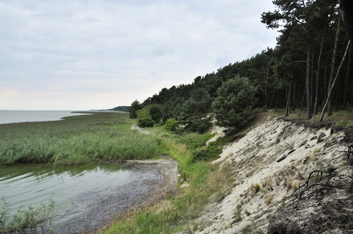
Najwyzszy pagór wydmowy - Wielbladzi (Garb) Grzbiet ma 48 m n.p.m.
Odmienny, bardziej monotonny charakter ma nizina przylegajaca do
Zalewu Wislanego.
Zadrzewienie Mierzei jest sztuczne. Jego glównym zadaniem jest
utrwalenie wydm oraz oslona zabudowan przed przewazajacymi tu
wiatrami z kierunku Zatoki Gdanskiej. Dominujacym gatunkiem drzew
jest sosna. Pojedynczo wystepuja brzozy a na obszarach nizej
polozonych przewaza bór mieszany, którym nie rzadko wystepuja buki
i deby. Cala roslinnosc Mierzei Wislanej jest pod ochrona
W zaglebieniach miedzy pagórami wydmowymi wyksztalcily sie
torfowiska wysokie i przejsciowe. W pasie przylegajacym do Zalewu
Wislanego wystepuja
zbiorowiska szuwarowe, a na wydmach zbiorowiska roslinnosci
nawydmowej.
Zróznicowane warunki siedliskowe sprzyjaja bogactwu gatunkowemu
flory i fauny. Mozemy tu spotkac m.in. gatunki atlantyckie, które
tu maja wschodnia granice wystepowania. Jest to teren szczególnie
cenny dla zwierzat, w tym ptaków, które tu zimuja, odpoczywaja w
czasie migracji oraz wyprowadzaja legi..Obszar ten jest wlaczony do
europejskiej sieci ekologicznej Natura 2000, jako specjalny obszar
ochrony siedlisk. Czesc ostoi wchodzi w sklad Parku Krajobrazowego
"Wysoczyzna Elblaska" oraz Parku Krajobrazowego "Mierzeja
Wislana".
Mierzeja (oprócz niewielkiej zachodniej czesci) jest slabo
zurbanizowana i praktycznie niezindustrializowana. Wszystkie
miejscowosci polozone w jej polskiej czesci (oprócz Gdanska) byly
niegdys wioskami rybackimi, a obecnie sa miejscowosciami
wypoczynkowymi. W sezonie letnim plaze Mierzeji sa intensywnie
wykorzystywane turystycznie.
Mierzeja
jest mlodym tworem geologicznym. Na Baltyku podobnie jak innych
akwenach morskich zachodza ruchy wody morskiej
Mierzeja Wislana powstala w wyniku akumulacji rumoszu
skalnego w strefie brzegowej Baltyku na skutek wzajemnego
oddzialywania wód morskich (fal), które niosly material pochodzacy
z abrazji wybrzezy klifowych (material wymyty z klifowego wybrzeza)
wód ladowych (Wisly i innych rzek ) nanoszacych material (piasek),
oraz dzialalnosci wiatru.
W rezultacie nakladania sie tych procesów powstal waski pas
nieregularnych wydm o stromych zboczach oraz równolegly do nich pas
piaszczystej plazy. (Zobacz obrazek pod tekstem)
 |
DEUTSCHE BESCHREIBUNG
|
DIE FRISCHE NEHRUNG
Die Frische Nehrung (polnisch Mierzeja
Wislana, russisch Baltijskaja Kosa) ist eine schmale
Landzunge (Nehrung) von ca. 70 km Länge und einigen hundert Metern
Breite (größte Breite 1,8 km), die in nordöstlicher Richtung
verläuft und das Frische Haff von der offenen Ostsee abtrennt. Quer
über die Frische Nehrung verläuft die Grenze zwischen Polen
(Woiwodschaft Pommern) und Russland (Oblast
Kaliningrad).
Der prußische Name lautete "Aismares" ("aislu": schnell + "mari,
mary": Haff). Zur Ordenszeit lautete der Name "Danziger
Nehrung".
Nehrung
Die Erscheinungen sind typischer für die gezeitenlosen Meere wie
die Ostsee, wo sie auch als Nehrungs-, Sand- oder Strandhaken
bezeichnet werden.Eine Nehrung entsteht durch Sandverdriftung bei
der Bildung einer Ausgleichsküste, aufgrund von schräg
eintreffenden Wellen (Küstenlängsströmung, vergleiche Abbildung).
In früheren Zeiten nutzte man diese Erscheinung zur Eindeichung.
Der vom Meer abgetrennte Teil wird Lagune, Haff oder Bodden genannt
und enthält durch den Süßwasserzufluss meistens Brackwasser.
Nehrungen können auch Dünen tragen.
(Siehe das Bild unter der Beschreibung)
 |
ENGLISH DESCRIPTION
|
THE VISTULA SPIT
The Vistula Spit is a sandy embankment between the waters of the
Gdansk Bay and the Vistula Lagoon. It stretches 50 km on the
territory of the Lagoon Region communes, from the Polish-Russian
boundary right behind Piaski, to the Vistula estuary. It has varied
width; from 0,4 to 2.5 km. The embankment is a work of nature - sea
waves and wind. The Spit dunes are mainly covered with pine and
mixed forests. Over 240 bird species dwell here, including at least
107 species of breeding ones. On the Vistula Spit there are
plentiful species of mammals, amphibians and reptiles (including a
turquoise kind of blindworm lizards). The unusual natural values of
the area have led to creating The Vistula Spit Landscape Park and
four nature reserves: Gull Sandbank, Katy Rybackie, Vistula Spit
Beeches and Sea-Holly Dunes. Around 220 species of birds dwell in
the Gull Sandbank Reserve, while in the Katy Rybackie
Ornithological Reserve there is the biggest in Europe colony of
Great Cormorants (35-40 thousand birds, including hatches). In the
Vistula Spit Beeches Reserve it is primarily Melic-Beech that comes
under protection (nearly 200-year-old trees).
The Vistula Spit has specific healthy coastal microclimate. The
arrangement of the Spit area is adjusted to tourism and stationary
recreation. Its tourist base is varied and can satisfy almost all
expectations of visitors.
Spit
Spit (landform)A spit or sandspit is a deposition landform found
off coasts. At one end, spits connect to land, while at the far end
they exist in open water.[1] A spit is a type of bar or beach that
develops where a re-entrant occurs, such as at cove's headlands, by
the process of longshore drift. Longshore drift (also called
littoral drift) occurs due to waves meeting the beach at an oblique
angle, and backwashing perpendicular to the shore, moving sediment
down the beach in a zigzag pattern. Longshore drifting is
complemented by longshore currents, which transport sediment
through the water alongside the beach. These currents are set in
motion by the same oblique angle of entering waves that causes
littoral drift and transport sediment in a similar process.
Hydrology and geologyWhere the direction of the shore inland
reenters, or changes direction, such as at a headland, the
longshore current spreads out or dissipates. No longer able to
carry the full load, much of the sediment is dropped. This is also
known as deposition. This submerged bar of sediment allows littoral
drift to continue to transport in the direction the waves are
breaking, forming an above-water spit. Without the complementary
process of littoral drift, the bar would not build above the
surface of the waves becoming a spit and would instead be leveled
off underwater.
Spits occur when longshore drift reaches a section of headland
where the turn is greater than 30 degrees. They will continue out
into the sea until water pressure (such as from a river) becomes
too much to allow the sand to deposit. The spit may then be grown
upon and become stable and often fertile. A spit may be considered
a specialized form of a shoal. As spits grow, the water behind them
is sheltered from wind and waves, and a salt marsh is likely to
develop.
Wave refraction can occur at the end of a spit, carrying sediment
around the end to form a hook or recurved spit.[1] Wave refraction
in multiple directions will cause a complex spit to form. Incoming
waves that come in a direction other than obliquely along the spit
will halt the growth of the spit, shorten it or eventually destroy
it entirely.[1]
The sediments that make up spits come from a variety of sources
including rivers and eroding bluffs, and changes there can have a
large impact on spits and other coastal landforms. Activities such
as logging and farming upstream can increase the sediment load of
rivers, which may hurt the intertidal environments around spits by
smothering delicate habitat. Roads or bulkheads built along bluffs
can drastically reduce the volume of sediment eroded, so that not
enough material is being pushed along to maintain a given
spit.
If the supply of sediment is interrupted the sand at the neck
(landward side) of the spit may be moved towards the head,
eventually creating an island. If the supply isn't interrupted, and
the spit isn't breached by the sea (or, if across an estuary, the
river) the spit may become a bar, with both ends joined to land,
and form a lagoon behind the bar. If an island lies offshore near
where the coast changes direction, and the spit continues to grow
until it connects the island to the mainland, it is then called a
tombolo.
The end of a spit attached to land is called the proximal end, and
the end jutting out into water is called the distal
end.
AUFGABEN:
1. Antworte die Fragen:
a) Was befiendet sich hier nahe
der A Koordinaten in der Einzeunung?
b) Welche Stadt sieht man von
den B Koordinaten
c) Du bist auf den C
Koordinaten- Worauf stehst du?
2. Mache drei Fotos
a) von Euch (Gps, Hand,TB...)
mit dem Blick auf das Haff (z.B. nahe der B Koordinaten)
b) mit dem Nehrungslandschaft
z.B. auf dem Weg zwischen A und C
c) von Euch (Gps, Hand,TB...)
mit dem Blick auf das Meer (z.B. nahe der C koordinaten)
(Alle Fotos, wenn möglich bitte mit Gps Koordinaten)
Bitte die Antworten an uns mailen!
Und Fotos an den log haengen.
Kreativität erwuenscht!
Viel
Erfolg!