 |
|
| You'll cross this bridge |
|
| |
Introduction
This cache is located in the
Frances Hildreth Townes Forest, 543 acres of conservation land
owned by the New
England Forestry Foundation. NEFF is running a GeoChallenge
this year: the "official" cache goes live May 20th or so. I've
received permission to place several other caches in the forest to
support the GeoChallenge cache, as well as the
Frog Rock CITO that took place on May 6th. As we all know, the
more caches there are, the more cachers there are!
This cache is part of the Excelsior Loop (see below).
Not a Park and Grab
There is nothing wrong with Park and Grabs, more power to you if
you hunt (or hide) them. I'm drawn to the more difficult caches,
mentally difficult or physically difficult. This is one of the
physically difficult one. You'll walk only a little more than 2
miles but at least 1.35 miles of that will be bushwhacking, trying
to decide if the dense woods is easier than the swamp. It took me
about 3 hours to walk the loop. You'll probably do better than
that; I was trying to figure out the loop as I walked it, along
with trying to take accurate GPS readings.
Even though it is hard, some good comes of the adversity, you'll
get to be pretty much alone with nature, this is very unlike a lot
of the forest land to the east in Manchester. There are few trails
and fewer people.
Multi Instructions
| |
 |
| |
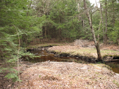
An oxbow |
| |
I've tried to make this as easy as possible. There is
nothing challenging about how the waypoints or the final are
hidden. The waypoints are written on blaze orange tape 2 to 5 feet
off the ground. For each waypoint I've omited the degrees and
tenths of a minute. This is to prevent any muggles from
following the trail. For example, if the orange tape says "2 9.876
/ 5.432" this means that you have 2 more waypoints to find, and the
next one is located at 42 59.876 071 45.432" Note carefully how the
42 5X and 071 4X are combined with the numbers on the tag. Also
note how I number my waypoints in descending order. The first
waypoint is numbered "2," the next one "1," and the next one "0."
This lets you know how many steps are left until the
final, not how many you've completed. I hope other multis adopt
this convention.
There are 3 waypoints plus the final. The first waypoint is at
the listed coordinates of the cache. It is on the opposite
side of a creek crossing near some downed trees. If the water is
low, this is a great place to cross. If it is high, you may want to
look upstream from here. (Don't look downstream, it gets worse.)
From this waypoint you'll bushwhack to the next one, skirting the
stream / swamp. You may need to cross other small creeks here. I
just found mud when I placed the cache.
The next waypoint is on 2 trees just in case one gets
"beavered." This is the waypoint that is furthest from the trail.
The walk here and to the next waypoint is full of wonderful water
and grass views. Note, if we get a lot of rain this could turn
swampy or even into a pond!
The final waypoint and the final cache will require you to make
short, but steep, climbs. You do not need any special equipment for
these, just good lungs and a good stout stick.
At some point you'll realize that you have to cross the stream
again. You can wade across but look at your topo map, I'm sure
you'll find where the cool rock bridge is.
The Final
The final is easy. If you've done 20 or more caches you should
be able to spot it from 20 feet away. Please hide it just as poorly
as I've hidden it. Muggles, if they ever got to this spot, will
think it is invisible but any geocacher should be able to find it
with ease. This is about the hike, not the hide. The container is a
decent-sized Lock and Lock, about the size of an ammo can.
Once found, you'll have an easy walk of less than 3/4 of a mile
down a smooth wide path to your car. Check out the old cellar holes
on your right as you go by. The 2nd one, the one closer to the car,
is huge and impressive. There are 2 covered wells at the 2nd set of
ruins. The one on your right has a wooden cover and still holds
water. The one on your left has a carved rock cover.
 |
|
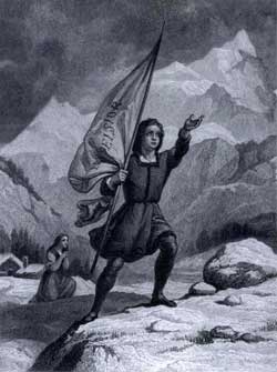
| 1846 illustration, reprinted in
"Longfellow: A Rediscovered Life" |
|
| |
Cautions
Bring bug and tick repellant. Wear long pants and sturdy shoes.
Bring plenty of water in the spring or summer. I did it on a cool
day and I didn't drink enough during the hike since it wasn't warm
and I really regretted it at the end. When you are near the 2nd
waypoint you'll also be near a posted private property line. You
can see the signs and follow the blazes on the trees. Please stay
on NEFF property.
A partner would be ideal. I didn't have one with me and at times
I felt really alone, usually after a minor ankle twist. I wished I
had one with me. Once you cross the stream there is only one other
crossing spot that I know of until you find the rock bridge. This
cache is difficult to abandon halfway through.
Excelsior!
Excelsior is a brief poem written and published in 1841 by Henry
Wadsworth Longfellow. There's a chess problem named after it. It's
long been used by auditioning actors and actresses as a stage
monologue. It's studied less frequently in schools now than it was
from its publication until well into the 1950s.
The young man, a stranger in the neighborhood, is climbing an
unfamiliar mountain in the dead of winter -- certainly an endeavor
to be compared with that of Don Quioxte de la Mancha. Like Don
Quioxte, the poem's protagonist is clearly mentally ill, having
escaped from an asylum before embarking on this alpine climb. Yet
-- again like Don Quioxte -- the reader finds in this madness a
certain extraordinary courage as well. Perhaps it is only the mad
among us who dare to take on the "impossible dream." Unprepared and
yet willing to keep climbing as long as he is able, the poem's
protagonist in the end falls prey to his delusions and, like other
climbers, dies in his attempt at greatness.
Longfellow is said to have selected the title of the powem from
the seal of the State of New York, though one cannot think of a
better word to sum up the courage, the steadfastness, and the sheer
insanity of this poem.
The shades of night were falling fast,
As through an Alpine village passed
A youth, who bore, 'mid snow and ice,
A banner with the strange device,
Excelsior!
Parking Instructions
The designated parking lot is on the 2nd NH Turnpike about a
mile south of the intersection of the turnpike with the
Lyndeborough Road. From the intersection, travel south for about a
mile until you come to Frog Rock Road on your left, which is (of
course!) unmarked. This road is just past Hopkins Road on your
right. Look closely for Frog Rock Road since it is somewhat
overgrown and on a sharp curve of the turnpike. Do not park on Frog
Rock Road (it is a Class 6 fire road), but rather park just to the
south where there is an unpaved wide spot that will easily hold 4
cars.
The Excelsior Loop
Since this area is not very populated, not many cachers visit
the area and I thought that placing several caches here would
attract cachers to the NEFF cache. This idea grew into the
Excelsior Loop. The Loop consists of the following caches
done in this order:
From the Nash Rambler cache you can then hike to the NEFF cache
directly or return to the Frog Rock Road and find the NEFF cache
with the letterboxing clues. When you do the loop you'll have
completed: a traditional, a multi, a micro, a letterbox hybrid and
a puzzle plus the traditonal disguised as a puzzle!
Note: Early logs will be deleted.