KITZLOCH CANYON EarthCache
-
Difficulty:
-

-
Terrain:
-

Size:  (not chosen)
Please note Use of geocaching.com services is subject to the terms and conditions
in our disclaimer.
|
|
|
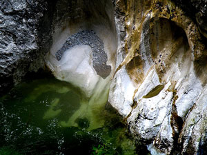
Over millions of years mountain streams such as the
Rauriser Ache carved bizzarre raviens and deep gorges into
Salzburg´s mountains. For centuries these were sinister, dark
places terror stepped in legend.
The gorge is about 1500 metres long, the height difference amounts
more than 100 metres. The gorge runs from the south after the north
and is protected as a natural monument. The gorge subsoil exists of
slate. The Rauriser Ache the narrowest place of the gorge, with the
real "Kitzloch" flows through first, then widens the gorge and
after an other narrow place into which at the side an influx than
waterfall pours forth, the valley opens in the direction of rate
brook, the river flows into the Salzach.
Only rarely would herdsmen stray into them in the search of missing
cattle; only rarely would the be roamed hunters. They offered
places of refuge to individuals on the run.
|
This only changed about 200 years ago, during the
Age of the Enlightenment. The romantic movement, too, embraced
Jean-Jacques Rousseau´s idealised landscapes with their rocks, fir
threes, balck forrest, impassable steep paths and precipices with
streams and waterfalls.
|
|
DEUTSCH:
Um diesen Earthcache loggen zu dürfen, musst du folgende Aufgaben
erledigen:
Fotografiere Dich und dein GPS beim
"EDELWEISSBLICK" BEISPIEL
1. Wie hoch ist die Höhendifferrenz zwischen dem
Eingang und der Einsiedelei
2. Wie entsteht Schiefergestein
ENGLISH:
To log this earthcache, send email with answers to the
following questions
and post a photo of yourself and your GPS near the "EDELWEISSBLICK"
EXAMPLE
1: Measure the height difference between entrance and "Einsiedelei"
2: How there originated slate


|
Additional Hints
(No hints available.)