Hoher Dörnberg EarthCache
-
Difficulty:
-

-
Terrain:
-

Size:  (not chosen)
Please note Use of geocaching.com services is subject to the terms and conditions
in our disclaimer.
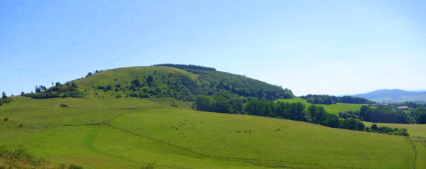
Hoher Dörnberg 
Der Hauptbestandteil des Dörnbergmassivs sind vor allem Muschelkalke. Den Mantel des Berges bildeten gewaltige Tuffsteinmassen, in die während desTertiär, eruptives, basaltisches Magma eindrang, das aber nur zum Teil an die Oberfläche trat. Dieser sichtbare Teil der basaltischen Eruption ist bekannt als der "Helfenstein".
Auf dem Muschelkalkrücken des Dörnbergs sind Pflanzenarten wie z.B. Orchideen und Enziane beheimatet, wie sie für einen Kalkmagerrasen typisch sind.
Funde aus vorgeschichtlicher Zeit belegen eine Besiedelung bereits zur Jungsteinzeit (4200 - 3500 v. Chr.)
Der an der Hangkante verlaufende Wall war vermutlich Teil einer keltenzeitlichen Burganlage (6. -1. Jahrhundert v. Chr.).
Du kannst den Earthcache loggen, sende mir aber per Email die Antworten auf folgende Fragen:
- Wieviel Schritte sind es von der Schutzhütte (N 51° 21.358 E 009° 20.994) bis zum Gipfelplateau?
- Der Begriff "Tuff" in Verbindung mit Tuffstein ist aus welcher Sprache entlehnt?
- Welche sind die wichtigsten Bestandteile von Basalt?
Logeinträge ohne oder mit falschen Antworten können gelöscht werden!
Bitte mache optional ein Foto von Dir und Deinem GPS, auf dem Gipfel mit den Helfensteinen im Hintergrund und füge es dem Logeintrag bei.
Der EarthCache liegt im Naturpark Habichtswald, bitte verhaltet entsprechend umweltbewusst und naturschonend!
Hoher Dörnberg 
Mussel lime is the prevailing part of the Dörnberg massif. The mantle of the mountain was formed by enormous masses of tuff stone. In that, during tertiary, eruptive, basaltic magma penetrated, what only stepped partly to the surface. This visible part of the basaltic eruption is known as the "Helfenstein".
On the mussel lime back of the mountain botanical species as for example, orchids and gentians are resident as they are typical for a limestone neglected grassland.
Findings from prehistoric time book a settlement already to the Neolithic Age (4200 - 3500 B.C.).
The rampart running at the plateau edge was presumably a part of a celt-temporal castle (6.-1st century B.C.).
You may log this earthcache, but email me the answers of following questions:
- How many steps you have to go from the protective hut (N 51° 21.358 E 009° 20.994) up to the mountaintop plateau?
- The term "Tuff" in connection with tuff stone has which linguistic roots?
- Which are the most important components of basalt?
Logs without or wrong answers can be deleted!
Please upload optionally a picture of yourself and your GPS on the top of the mountain with a nice view in the background.
The EarthCache is placed in the nature reserve Habichtswald, please behave in an environmentally friendly way!
Additional Hints
(No hints available.)