Please note the break of accessibility of the moor during winter and autumn months (due to the regeneration of the flora and fauna). Enquire about it before you go up. Thank you.
Tasks - please do not put the answers for 2. and 3. in your log! Mail them to me instead (in English, German, or Russian). You can log your find immediately after sending me the answers. You don't need to wait for approval. Also, please use English as your log language.
1. You have to take a picture of the moor and one of you and your your GPS on top of the look-out post. Or at least in front of it with a bit of moor visible too. This has to be posted in the log. And no, photoshopping you into a picture does not count! Be honest!
2. I also want to know how high the look-out wooden tower is (approximately). I mean the one overlooking the moor.
3. How many trees over 5 metres do you see directly in the moor?
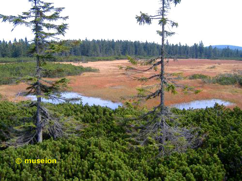
The Giant Mountains are home to a few sub arctic high moors. On top of Cerna Hora - the Black Mountain - lies one of the few High Forest Peatlands still accessible and mostly untouched in the last few decades. The largest raised bog - a forest peatland - lies in the saddle between Cerná hora (Black Mountain) und Svetlá hora (Light Mountain) in the spring area of the River Cernohorský potok (Schwarzenberger Bach in German). The Czech name is "Cernohorské rašelinište". The average altitude of the area is about 1000 metres.
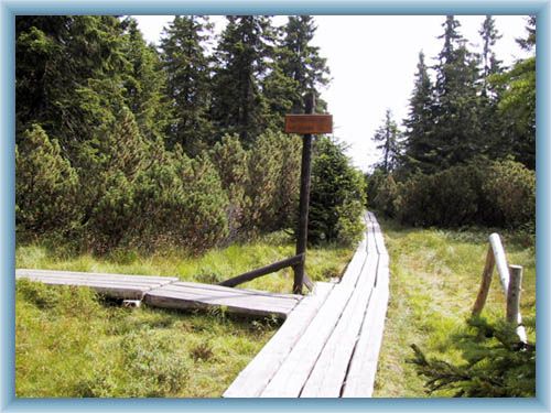
About 60 Hectares in size, up to 2.5 metres deep and with a volume of 420.000 m3. There is about 1.400 mm of annual water coming down on the mountain and the snow lies normally between November and May. Sometimes the hight of the snowcover reaches 3 metres. It is not warm here - statistics show an approximate 2 °C as the annual average. From 1952 onwards it belonged to a protected zone class 1 in the National Park. This means you are not allowed to stray from the path. Even if you dared, you would be likely to sink into the moor. Please remain on the wooden planks leading through the peat forest.
Bogs develop under conditions of low temperature, high acidity, low nutrient supply, stagnant water, and oxygen deficiency. Everything can be found here on top of this mountain.
Peat forms when plant material is inhibited from decaying fully by acidic and anaerobic conditions, usually in marshy areas. It is composed mainly of marshland vegetation: trees, grasses, fungi, as well as other types of organic remains, such as insects, and animal corpses. This means an accumulation of partially decayed vegetable matter. Peat forms in wetlands or peatlands, variously called bogs, moors, muskegs, pocosins, mires, and peat swamp forests. Because of the challenging ecological conditions of peat wetlands, they are home to many rare and specialised organisms that are found nowhere else.
Peat layer growth and the degree of decomposition (or humification) depends principally on its composition and on the degree of waterlogging. Peat in very wet conditions will grow considerably faster, and be less decomposed, than in drier places. This allows climatologists to use peat as an indicator of climatic change. The composition of peat can also be used to reconstruct ancient ecologies by examining the types and quantities of its organic elements.
Under the right conditions, peat is the earliest stage in the formation of coal. Most modern peat bogs are formed in high latitudes after the retreat of the glaciers at the end of the last ice age, some 9,000 years ago. They usually grow slowly, at the rate of about a millimetre per year.
The peat in the world's peatlands has been forming for 360 million years and contains 550 Gt of carbon in the world.
The administration of KRNAP offers an 3.5 km trail with 6 educational tables. The trail is open from 1.6. till 15.10 and goes through some of the most valuable parts of the Krkonose National Park - 1st and 2nd zone. There is, however, no entrance for cyclists to the peatland!
The path is not only educational but offers beautiful panoramic views too. It is well worth going.
And since you are already here I would like to draw your attention to another cache nearby: GCK943
Additional information:
If you want to read further information I recommend the homepage of the park administration: www.krnap.cz or the shortened english version: english.krnap.cz
This site here can be quite educational too: www.peat-portal.net
Wikipedia offers also quite a few entries on peat, bog, Moor, Hochmoor, ... as do other educational sites and lexica.
Local legends and stories speak of people going amiss, vanishing, or being "deposed off involuntarily" in the moor in the past centuries. Be as it might, please be careful on top.

Congratulations to midlan for logging it within 12 hours of publishing. :)