Dolina Prądnika / Pradnik Valley EarthCache
Dolina Prądnika / Pradnik Valley
-
Difficulty:
-

-
Terrain:
-

Size:  (not chosen)
Please note Use of geocaching.com services is subject to the terms and conditions
in our disclaimer.
O skałach i wodzie
Odwiedź dolinę i dokonaj kilku obserwacji geologicznych i hydrologicznych.
On rocks and water
Visit the valley and make a few geological and hydrological observations.
[PL]
O Dolinie Prądnika (na podstawie strony dolina-pradnika.pl i nie tylko):
Dolina Prądnika położona jest w województwie małopolskim, w południowej części Wyżyny Krakowsko-Częstochowskiej. Została ukształtowana przez płynące wody powodujące procesy krasowienia skał.
Podłoże geologiczne omawianego terenu stanowią wapienie górnej jury, które powstały ok. 150 mln. lat temu z nagromadzenia ogromnej ilości szczątków organizmów żyjących w ciepłym morzu jurajskim. Ich miąższość osiąga ok. 200 m . Barwa ich jest z reguły biała, jasnożółta lub jasnoszara. W Dolinie Prądnika występują dwa typy wapieni: skaliste i uławicone. Wapienie skaliste charakteryzują się największą odpornością na procesy denudacyjne, wyróżniają się dużą twardością i zwięzłością, spękaniami ciosowymi, oraz brakiem krzemieni. Oprócz gąbek zawierają mało skamieniałości. Wapienie te, ze względu na znaczą odporność na wietrzenie odgrywają dużą rolę w kształtowaniu rzeźby terenu. Wapienie uławicone charakteryzują się natomiast wyraźnym uwarstwieniem, znaczną ilością skamieniałości, głównie ramienionogów, oraz występowaniem krzemieni. Wapienie te, bardziej podatne na erozję, tworzą obniżenia pomiędzy ostańcami oraz zagłębienia rozdzielające skałki na zboczach dolin.
Tworzenie się obecnej rzeźby terenu rozpoczęło się w paleogenie (starszym trzeciorzędzie). Wówczas doszło do powstania rozległej, lekko falistej wierzchowiny. Pod koniec trzeciorzędu (pliocen) wykształciła się obecna sieć rzeczna wskutek czego rozpoczęło się pogłębianie Doliny Prądnika i uchodzących do niej dolin bocznych. Między etapami intensywnego pogłębiania doliny, były okresy zastoju i wzmożonej erozji bocznej. Z tymi okresami związane są poziomy terasowe, widoczne na obu zboczach Doliny Prądnika w postaci teras skalnych. Fragmenty zerodowanych teras tworzą malownicze bramki, iglice skalne i inne formy skałkowe.
Za powstanie doliny odpowiedzialny jest przede wszystkim Prądnik. Strumień ten, zazwyczaj niewielki, w okresie wezbrań zwieksza swój przepływ nawet ponad stukrotnie. Dokonywana przez wodę płynącą erozja powierzchniowa wciąż postępuje, przede wszystkim w okresach wysokiej wody.
Dwa inne typy erozji występujace w dolinie to: erozja na skutek działania wód podziemnych prowadząca do powstawania jaskiń oraz erozja lodowa, gdy woda wnika w szczeliny skalne i zamarzając rozsadza je, odłupujac nieraz spore ich kawały. Ten drugi rodzaj erozji jest szczególnie widoczny w miejscach, gdzie w okresach przejściowych występuja duze wahania tempratur między dodatnimi i ujemnymi.
Twoje zadania:
- Część I, geologiczna:
- W punkcie T1 znajdź wylot bocznego wąwozu - Bramę Krakowską. Jak szeroka jest ta brama? Z jakich skał jest zbudowana i po czym to poznać?
- W punkcie T2 znajduje się skalny monolit - Igła Deotymy. Porównaj północną i południową stronę Igły. Z czego mogą wynikać różnice?
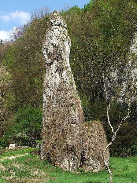
- W punkcie T3 znajduje się najbardziej znany obiekt Doliny - Maczuga Herkulesa. Oszacuj jej średnicę u podstawy oraz średnicę jej głowicy.
- Część II, hydrologiczna: Punkt T4 to dobre miejsce, by przyjrzeć się Prądnikowi.
- Jaki jest, Twoim zdaniem, stan wody w strumieniu: niski (susza), średni, wysoki, czy bardzo wysoki (powódź). Z czego ten stan wynika? A może strumień jest skuty lodem? Jeśli tak, to czy widać podlodowy przepływ?
- Oszacuj szerokość b i głębokość h strumienia w metrach oraz prędkośc wody v na jego powierzchni w metrach na sekundę (możesz wrzucić liść lub źdźbło; nie wrzucaj śmieci!). Używając przybliżonej formuły Q=bhv/4 oszacuj przepływ w Prądniku (w metrach sześciennych na sekundę). Punkt ten nie obowiązuje w warunkach bardzo wysokiej wody, gdy woda jest zamulona, lub gdy rzeczka jest poktyta lodem.
Nie pisz odpowiedzi w logu! Wyślij je do mnie (Murazora) używając formularza kontaktowego.
Zamieszczenie w logu zdjecia jest mile widziane.

[EN]
About the Prądnik Valley (based partially on the dolina-pradnika.pl page):
Pradnik Valley is placed in Lesser Poland in the southern part of Cracow-Częstochowa Upland. It has been shaped by flowing water eroding limestone rocks.
The geological base of the site are the Upper Jurassic limestones, which arose around 150 million years ago from the accumulation of vast quantities of remains of organisms living in the warm Jurassic sea. Their thickness reaches about 200 m. Their color is usually white, pale yellow or light gray. In the Valley there are two types of limestone: rock (hard) and grainy (soft). Rock limestone shows high resistance to denudation processes. It is characterized by high hardness and compactness, straight cracks, and the lack of flint. It contains almost no fossils besides sponges. These limestones, because of their significant resistance to weathering, play an important role in shaping the terrain. Grainy limestone is characterized by distinct stratification, a significant number of fossils, (mostly brachiopods) and the occurrence of flint. These limestones are more vulnerable to erosion. They form outliers and cavities between harder rocks remnants.
Formation of the present terrain relief started in the Palaeogene (older Tertiary). That time due to Alpine orogenesis a slightly wavy plateau emerged. At the end of the Tertiary (Pliocene) the current river pattern formed including the Prądnik creek. Flowing water began to erode the Pradnik Valley and its side valleys. Between the stages of intense deepening of the valley, there were periods of stagnation and increased lateral erosion. These periods created terraces, visible on both slopes of the Prądnik Valley. Eroded fragments form a picturesque landscape full of gates, spires, towers and other rock forms.
The Prądnik creek is the main factor that created the valley. This stream is usually small, but in high water periods its discharge (total flow) increases a hundred times and more. Surface water erosion still continues nowadays, especially in times of high water.
Two other types of erosion that still occur in the valley are: erosion by the ground waters (it leads to the formation of caves); and ice erosion when water penetrates the cracks in stone, then freezes splitting off parts of the rock, sometimes quite big ones. This second type of erosion is particularly active in areas where there are long periods when temperature swings between positive and negative values.
Your tasks:
- Part I, geological:
- Find waypoint T1. There is an entrance to a side gorge here, so called "Cracow Gate". How wide is this gate? What kind of rock forms it and how one can recognize this?
- Waypoint T2 leads you to the rock called Deotyma's Needle. Compare the surface of northern and southern side of the Needle. What differences can you see and what may cause them?
- At waypoint T3 you can find the most famous rock of the Valley - the Mace of Hercules. Estimate the diameters of its base ("neck") and its head.
- Part II, hydrological: Waypoint T4 is a good place to take a look at the Prądnik Creek.
- What is in your opinion the qualitative water level in the creek: low (drought), normal, high, very high (flood)? Or maybe the creek is ice-covered? If so, can you see sub-ice flow?
- Estimate the width b and depth h of the creek (in meters). Estimate the velocity of water on its surface (in meters per second; you may throw a leaf or a straw in, don't throw in any litter). Using the following approximate formula Q=bhv/4 estimate the total discharge of Prądnik (in cubic meters per second). Caution: this task is not mandatory if the creek is ice-covered, if the water level is very high or if the water is muddy.
Don't write your answers in the log. Send it to me (Murazor) via the contact form.
Attaching a photo to the log is welcome but not mandatory.
Additional Hints
(No hints available.)