Geologic & Human History
Mount Mansfield and the Green Mountains are a part of a great range
of mountains that stretches from Alabama to Newfoundland and even
beyond North America to Greenland and the British Isles. The types
of rocks around Mount Mansfield and the way they have been folded,
broken, and changed by intense heat and pressure reveal a history
that extends across hundreds of millions of years - all part of the
grand "plate tectonics" story in which 100 kilometer-thick "plates"
move one or two inches a year carrying continents across the
Earth.
Sendiments to Mountains
About 400 million years ago, when the forces of plate tectonics had
not yet carried the North American continent out of the Southern
Hemisphere, a chain of volcanic islands collided with the eastern
shore of North America. The island chain scraped and uplifted ocean
sediments to create the Green Mountains.
Changes in the Rocks
The intense heat and pressure of this mountain-building event
metamorphosed the ocean sediments causing their minerals to
recrystalize. A common green mica named chlorite is present in many
of the rocks of Mount Mansfield and the rest of the Green Mountains
- it's this green rock color that gives the mountains their name.
Flow within the rock during recrystallization caused minerals to
migrate into discrete bands. Look for these wavy bands of mineral
layers, called foliation.
Mountains Back to Sediments
In the absence of further uplifting, the constant force of erosion
by wind, water, and ice has removed as much as fifteen kilometers
of rock. Areas like Mount Mansfield stand higher today because the
underlying rocks are physically and chemically tougher than those
under the valleys.
The most recent major erosional events have been the advances
and retreats of continental glaciers (like those today on
Greenland) that were thick enough to completely bury Mount
Mansfield. The leading edge of the most recent continental glacier
melted back to the north around thirteen thousand years ago. The
newly exposed rocky landscape showed marks of the mile-thick
glaciers: widened U-shaped valleys and smoothed hilltops. Under its
own massive weight, the glacial ice had flowed southeast toward the
sea, carrying the rocks and sand that formed Long Island and Cape
Cod. Look for scrape marks, two-inches wide and several feet long
on the ridgeline where rocks were dragged like sandpaper across the
bedrock.
Human History
Abenaki Indians called the mountain Moze-o-de-be-wadso
(mountain with the head of a moose). In 1772 Ira Allen, brother of
Ethan Allen, crossed the ridgeline while surveying the town of
Mansfield. Nearly 100 years later, in 1859, William Henry Harrison
Bingham sold 400 acres along the ridgeline to the University of
Vermont for $1,000. The deed stipulates that the land be used for
scientific purposes.
Today
In the face of fifty thousand visitors each year, summit caretakers
from the Green Mountain Club patrol the ridgeline to assist hikers
and protect the fragile summit ecosystem. Pressures to meet demands
for expanded telecommunication facilities, ski trails, and other
uses need to be balanced with protection of this unique
environment. Ongoing research includes assessment of alpine plants
as well as migratory birds that breed in the high-elevation forests
of Mount Mansfield.
Reference: The Tundra Walk: An Interpretive Guide to the
Mount Mansfield Alpine Region
|
Parking Options
- Mt. Mansfield Auto Toll Road Parking (1.5/2.5) This is
the most expensive option at 24$ per car. However, the complete
hike will be 2.2 miles in and out.
- Underhill State Park Parking (1.5/3.5) This is the
cheapest option at 2.50$ per person. However, the complete hike
will be 8.8 miles if performed via a loop hike. Please note that
camping options are available at this parking location.
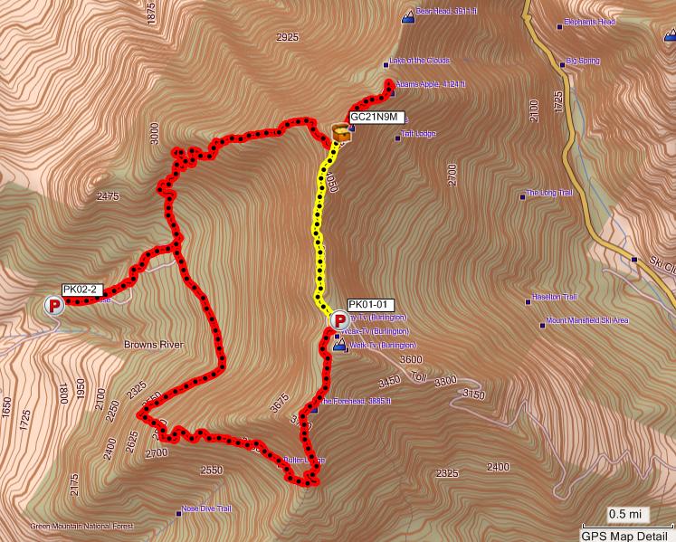
Note: Please see the tracklog to the right. This
Earthcache only requires the hike outlined in Yellow. If you
combine both the Yellow and Red tracklogs, this is the hike that
can be expected using Option 2 above via a loop hike. |
 |
Logging Requirements:
- Find an example of foliation and post a picture with GPS
coordinates. What is the distance between folds?
- Find an example of scrape marks where rocks were dragged across
the ridgeline bedrock and post a picture. Which way were the rocks
moving?
- Post a picture of yourself with GPS on top of Mount Mansfield
with the benchmark clearly visible.
Note: All answers should be emailed to the cache
owner.
Picture Examples
 |
 |
 |
| Picture 1: Foliation Example |
Picture 2: Scrape Mark Example |
Picture 3: Mount Mansfield Benchmark
Example |
Note: In Picture 2, the scrape marks on the rock in the
lower right hand corner are indicative that there was movement of
harder rock across it. However, the logging requirements are to
find an example on the ridgeline bedrock (ie, not on a
erratic).